With the latest imagery update, France goes Dutch, discovers Henri Willox at Le Blogue du LFG. By which we mean that several places get higher resolution imagery, except that sensitive sites happen to be there, and these are now reduced to 20-meter resolution pixels. (Just like the Dutch imagery Google Earth got last year.)
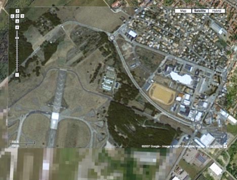
Because Google Maps hasn’t updated yet, Henri is able to show with screen shots two before-and-after cases. I myself took a Google Maps screenshot and
overlaid it on Google Earth so you can check the difference for yourself using the transparency slider:
I do wish there was full disclosure in these update announcements. If there is a new dose of censorship somewhere, whether justified or not, I’d much prefer to be told right off the bat rather than have to find out via wily bloggers. Organizations that aim to organize the world’s information should despise censorship, and when it happens, document it as a necessary evil, if that’s what it is.
Further to the Dutch censorship, if you check out the Amsterdam Maritime Museum, it’s censored. However, if you have the 3D buildings layer turned on, pretty much all of the buildings on the site are there.
Kind of nullifies the original purpose of the censorship.
It’s at Lat 52.3718º Long 4.91484º
We don’t necessarily look at all the imagery that goes into the system, that would be a very time consuming process. Censorship in the source imagery, though annoying, is something we can do little about.
That’s alright. I guess the terrorists can just walk into the airport and get a paper map with the layout anyway. No sense in providing utility to the masses to figure out where to park or drive up to to drop their loved ones off safely or anything.
By the way. Does anyone have any statistics on how many traffic accidents are prevented at locations as a result of online mapping visualization – vs. – prior to their use? Just curious if anyone’s done a study to see how many lives have been saved, injuries prevented, accidents prevented, damages prevented, and insurance costs down – as a result of online mapping. That’s all.