I’m a relatively bad skier. That’s okay, I’ve only done it three times before in my life, so I can still pretend that I’m a fast learner, especially as I have friends who are very good skiers and who are glad to teach me. They also think it is hilarious to take me up steep slopes and then watch me tumble down them — as was the case with my ascent by cable car of the Mont Fort mountain (3,330m) near Verbier in Switzerland earlier this week, and the far less dignified descent on skis down a glacier. But at least you can appreciate the view when you’re on your ass in the snow.
All this as a prelude to the absolutely stunning imagery and terrain upgrade of Switzerland (and other places) that the Google Earth team rolled out on February 28. I had last checked up on Mont Fort in Google Earth what must have been hours before the update, and the difference is spectacular.
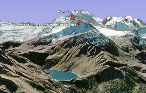
The terrain (DEM) upgrade to a resolution of 10 meters for all of Switzerland is probably the most important single improvement. Now, mountain lakes and dams are rendered with pinpoint accuracy, and mountain slope imagery no longer suffers from misalignment with the DEM.

The terrain upgrade also makes Google Earth what must be the best tool anywhere for planning your skiing (in Switzerland). This is 3D terrain information that is actually usable, and ski resort operators would be crazy not to build a version of their ski slopes in Google Earth, where they show cable cars routes with actual buildings, annotated ski slope routes, off-piste suggestions and even avalanche-prone areas. And if you’re a GIS developer, you’d be crazy not to pitch this idea to them:-) especially as the intended users won’t be businesses and hence don’t need Google Earth Pro licenses to consume your work.
I had a quick go drawing the routes of the cable cars that take you from Verbier to Mont Fort, just as a proof of concept. As an added bonus, the new imagery shows an actual ski trail of somebody summer skiing on Mont Fort’s glacier. It’s not as scary as it looks. On my way down, I eventually came to rest near a Swedish mom commending her helmeted child on what a fine job he had done skiing down the glacier. I called out to my expert skiing buddy, “look, I’m being beaten by a 10-year old boy”, only to have me corrected by the mom, “actually, she’s a 6-year old girl.” That’s how the Swedes produce those Anja Pärsons.
I really wish I had taken my GPS device with me (Nokia N95, where are you?) but with standard DEMs, there really isn’t much point when trying to track your progress in mountains on Google Earth. Now (in Switzerland), GPS tracking and DEMs have similar accuracy, and that makes all the difference in a mountainous region.
<rant>As an aside, this kind of high resolution data — both imagery and terrain — is occasionally referred to cynically on NASA World Wind developer’s blog Bull’s rambles as being wonderful if all you want to do is look at your own house. I think that misses the point entirely (perhaps intentionally). Sub-meter imagery resolution makes available a whole new world of social information, because it is at this resolution that we can start seeing objects that we interact with in our daily lives. I think it’s the killer feature for geobrowsers, but there is also a more serious benefit, and this was shown during Katrina and the Pakistan quake, back in 2005. In these cases, seeing somebody’s house became a matter of life and death. In other cases, this kind of resolution can document human rights abuses. If I can also see my own house, that’s great. </rant>
Finally, here are the rest of the improvements, as noted on Google Earth Community:
- Entire country of Switzerland at 50cm and many Swiss cities at 25cm (thank you, Endoxon)
- Entire country of Switzerland terrain at 10m, the Swiss Alps are now high-res!
- Entire country of Denmark at 50cm
- Australia day flyover
- Cities of France: Lyon; Le Mans; Lourdes; Reims; Nancy; Limoges; Lille; Arles
- Potsdam and Magdeburg, Germany
- Barcelona, Belem, CapeTown, Galapagos (Isabella Island), Manaus, Mt Saint Helens, Recife, Rio, Venice)
- Whistler British Columbia
- Full state coverage for Wyoming & Utah
- significant amounts of new Digital Globe data
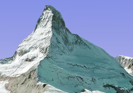
Oh, I almost forgot. Gratuitous shot of a pixel-perfect Matterhorn:
Perhaps it’s not the best of ideas to rely on a commercial enterprise to make available (for now, at least) such great deal of important social information? What happens when they update the data and the current batch of important social information is taken away in favor of another batch of important social information?
PS: Be careful or your screenshots sans copyright notices will earn you a love note from Google legal. ;)
I asked somone about this and it is a commercially available Digital Elevation Model which is 7 years old from NASA. It would thus cover lots and lots of the earth’s surface, at 10m vertical accuracy and 100m er . . heighth(?) so GOOG could roll it out in many more places. But it is not viable for proper commercial apps like flood insurance, and you could still fall off cliffs and stuff if you were relying on it to go skiing and not looking.
Incidentally this is what Virtual Earth is doing with its coverage of the UK from Intermap, adding a much more accurate DEM at much higher vertical accuracy, sub 1m or so which you could ski remotely with. Hopefully it will look great too. It is not ready yet I checked on Mount Snowdon and my grandma’s house.
Hmmm, this new Swiss terrain. Resolution is not everyting. Check out Dom, at N 46:05:39 E 7:51:33. Instead of a 4545m summit, there is a large flat plateau that is no higher than 4440m. More than 100 metres have been lopped off. There are also summit inaccuracies on the Matterhorn, plus overhanging shadows which show that there is still a DEM misalignment problem.
Also re the Intermap DEM of the UK, I acquired the part of this that covers the Cuillin mountains of Skye in Western Scotland, and I was not at all impressed. It did not do justice to its claimed 5m resolution, one major summit was more than 100m too low.
“If I can also see my own house, that’s great.”
I agree.
But if someone judges a virtual globe by just this one ‘feature’ (we get tons of these “i can’t see my house in X, WW sucks and it wasted my time” from n00bs) then something is not OK. Of course you can waste many hours and write many replies trying to explain that virtual globes can offer more than just ‘seeing your house’, but some people (majority?) will never understand that. They don’t care about Katrina or Pakistan, they want their house! :)
So Bull’s rants were more about n00bs than GE and hi-res data itself…
eurof any idea what the name of the DEM data set is? If it was made by NASA I’d be interested to know why it isn’t in World Wind.
ok I really can’t let a rant at me pass can I? Yes I believe seeing your house isn’t everything, but I agree it’s nice and can be useful. I will point out that the Katrina imagery rushed out (with help from people at NASA) was very poorly georeferenced, so not ideal for helping people on te ground, now World Winds Katrina Data Add-On. was near perfectly georeferenced and used by the national guard.
Also although I don’t beleve high resolution imaagery is everything, FEF (I am on the board of drectors) is dedicated to giving people access to free geospatial data, much of which is high resolution, notice I said ‘free’, unlike google we want people to be able to use the data in any way they like, and freely redistribute it.
Perhaps a naive question, but:
This “10m resolution” terrain…is that the spatial resolution or the vertical resolution?
Perhaps a naive question, but:
This “10m resolution” terrain…is that the spatial resolution or the vertical resolution? And how does this compare with the SRTM terrain in other parts of the world?
Usually it means spatial resolution, i.e. the data points lie on a grid at 10m spacings.
SRTM is ~90m outside the US and ~30m inside. If you want better than that then you have to pay for it.
@Eric – thanks for answering my question. I imagine google, with all its resources, could afford to roll out some very high resolution LIDAR data for a few cities, much like the Virtual London projects. But that sort of data might conflict with their current strategy of populating cities with user-created 3d models.
“SRTM is ~90m outside the US and ~30m inside. If you want better than that then you have to pay for it.”
Not for the Alps, you don’t. See the 1″ (30m) data at http://www.viewfinderpanoramas.org/dem3.html#alps – and the highest cells on Dom and Weisshorn are 4543m and 4501m respectively, not 4440m.
Those are nice, but where is the metadata with the source lineage and contact info? As far as we can tell those might just collections of random numbers from the internet. :p
Bull, I am afraid I don’t know the name. I vaguely remember being told the space shuttle was involved. Everything (and it is not much, I am more a finance person) I know about this stuff is at work I will try and remember when I get back monday.
Hi Erik, the contacts and sources are elsewhere on the linked page. There are also links to panoramas generated from these data, alongside panoramic photographs.
All it says is that they came from topographic maps. There is no indication which maps any particular data came from, nothing about the process used to ensure data quality of the source maps or of the digitization, and, most importantly, nothing about the copyright status of the individual source maps.
Something like this for each file is what you need:
http://www.apa.state.ny.us/gis/shared/htmlpages/metadata/10mDEM.html
Please Erik, take time to read http://www.viewfinderpanoramas.org/dem3.html and other linked pages. You will find adequate information about the matters you raise, including the accuracy and copyright issues. The 1″ Alps files have been posted fot nearly 12 months, and have been widely used.
See also https://www.ogleearth.com/2006/10/3d_nature_puts.html
The only thing you say about non-SRTM sources is that you used topographic maps, “many and various”. Also, your statement about topographic data itself being ineligible for copyright may or may not be true, but that doesn’t mean you can digitize copyrighted maps and declare the resulting data to be free. Just because no one has bothered to come after you for it yet doesn’t make it legal.
For example, if I wanted to make sure that that the data in the following file was in agreement with the source map data, and that the source map was public domain, where would I start?
http://www.viewfinderpanoramas.org/%5Cdem1%5Cn45e008.zip
Don’t get me wrong, I like the work that you are doing with that data and think that it has many potential uses. I just don’t think that reliable PD mapping applications are one of them until someone downloading the data can be sure that they won’t end up with some government mapping agency from halfway across the world coming after them for using data without permission.
Fair comments Erik, and I openly deny that all my map sources are PD, and I make it clear that commercial users should be aware of this. But my site has permitted the use of DEM data by many for whom DEM data from national surveys would be prohibitively expensive. If national surveys chose to stop this happening, perhaps they could, but fortunately that has not happened.
Further to the above comment, I don’t think that ultimately, national surveys want to restrict the use of their work. The latest Google images of the Dom, Weisshorn, Matterhorn and Toedi summits illustrate the shortcomings of collecting mountain DEM data from space, as opposed to using the best DEMs from maps from good quality ground surveys. But if national surveys enforce copyright combined with high pricing, DEM data from space will dominate the earth viewing services. For those of us who like to see accurate summit images, and for ground surveyors who want their work to be used, that will be sad.
After further research I have concluded that the errors in the new Swiss terrain are isolated and that the great majority of mountains are well mapped. It would be interesting to know:
(i) who owns this terrain (Endoxon?)
(ii) how and when it was captured
(iii) whether or not it is publicly available and if so at what price
(iv) the cause of these errors in flagship mountain summits and when they will be fixed. This should not be too difficult.
OK sorry but this is just not accurate:
“Entire country of Switzerland at 50cm and many Swiss cities at 25cm (thank you, Endoxon)
Entire country of Switzerland terrain at 10m, the Swiss Alps are now high-res!”
I live in Switzerland and they missed out a bunch of it. Most of the bits I know, anyway, and some very populous bits, the whole Swiss riviera. Check out Chateau Chillon, almost defintely in Switzerland, and worth a visit if you do come over, it is one of the highlights. 50cm, 10m? High res? My arse. More like 1km.
“Eurof” (is that really a name?), I think you need get a better internet connection or else a better computer. Chateau Chillon is in high res.
Hmph. Some googletron clearly fixed it after they saw my comment. Although it is possible my connection was acting up a bit yesterday.
Anyway, “50cm” seems to me to be not a relevant measurement of anything I can see in this picture, let alone “25cm”. Also, having taken many of my visitors there, I know the Chateau is over 10m in height, yet the area is flat as a pancake in GE. They should spend more on their DTM next time.
And while I may have been wrong about the Chateau, I maintain that large parts of Switzerland which I travel across frequently are NOT hi res at all. Move North from Geneva and there is a large white patch from the airport to Coppet which is lower res. Just north of CERN too. Complete with clouds.
So I am still right. And I will take criticism of my name from many people, but not someone whose last name sounds like a pair of denim trousers.
Nope, the clouds are in France, and near Coppet the cars are 4 pixels across, which is about right.
Right, that’s why portions of the lake are higher than the shore. The poor fools living in Versoix are clearly about to be crushed by a massive tidal wave.
What is it, 25cm per pixel, then?
And normally the lake is so placid too.
I’d really like to get my hands on some 10m DEMs of the Alpes with associated 1 meter orthophotos so I could do some 3dSkiMaps treatments. If anyone can point me in the right direction, even if I have to pay for it – please! I’ve been looking for this stuff for ages.
extremely gorgeous, thanks a lot.good luck
THANK YOU SO MUCH, JUST GORGEOUS. OUTSTANDING VIEWS.\\
GOOD LUCK NEXT
JUST OUTSTANDING. THANK YOU SO MUCH.
SHAMAN
Wow great stuff.
This is Amazing,seeing the reality of far away images in front of us.
thanks google
regds,
Bommy
This is great + thanks for the review. I just wish Google would do the same for the Caucasus, where no accurate maps are available and Google Earth is the only reliable tool…
It would bring more local people online, too, and become a really transformative experience for them.
When will the island of Utila, off the coast oof Honduras be improved? It’s a great scuba diving spot.
Thanks
Jim
My beautiful son Hayden died on the 24th March when he slipped on ice and fell 100 meters into a ravine. It is a very dangerous sport.
I read about your son. My condolences to you.