Google: Sweden now part of Norway (Shock!)

Just about every online publication you can find in Norway right now, and a Swedish paper to boot, is reporting on how if you type “Norway” into Google Earth, it directs you to a spot in the middle of Sweden. Considering that Norway was a part of Sweden until 1905, this is getting a lot of play — the official angle is that according to Google, Sweden now belongs to Norway. (It’s funny in an understated Scandinavian sort of way — you really had to be here.) In some cases, photo editors have conveniently helped along the story by turning off the country names layer before taking the screenshot, as on that layer the names are marked correctly, and that would just ruin the fun.

sweno.jpg

But why might a search for Norway in Google Earth end up with a placemark in Sweden? My first guess was that Google somehow finds the center of gravity of a country, and in the case of Norway, the country is so oddly shaped that it could just conceivably fall outside the borders of the country itself. But just from looking at Norway, there is no way that the center of gravity would be that far into Sweden.

vietlaos.jpg
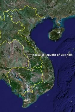
Instead, I think I’ve figured it out. What Google returns is the coordinate point whose longitude is halfway between the easternmost and westernmost point of a country, and whose latitude is halfway between the northernmost and southernmost point. In the case of Norway, that’s far into Sweden. In the case of Sweden, that’s just into the Baltic Sea. There are in fact few countries where this point does not actually fall within its borders. I had to do a bit of a search, but finally found Croatia, Israel, Laos and Vietnam. If you find others, do let me know.

This is obviously a completely arbitrary piece of geographical trivia, as we’d merely have to agree on using a different reference frame for our coordinates and we’d get different answers. Even so, I reckon Croatia would have a hard time finding any coordinate system that allows this point to fall within its borders. Just nobody tell the Bosnians they “belong” to Croatia, or it’ll be 1992 all over again.

Swiss paper: Details about Endoxon purchase

Local Swiss paper Le Temps has some further interesting details on Google’s acquisition of Endoxon. If you speak French, read it here, else the highlights are below, translated:

The contract was signed last friday, the price of the agreement was not disclosed, and it’s the first Swiss company bought by Google.

Endoxon was founded 18 years ago by two bothers, Stefan and Bruno Muff. Until last friday, it employed 80 people, with offices in Switzerland, India and St. Petersburg. Its Indian subsidiary assembles satellite images of different countries (Switzerland, Germany, Austria, Japan, Dubai…) and adds layers of points of interest.

“We are the best,” assures Samuel Widmann, Endoxon’s [ex-]CEO. “Nobody in the world assembles as much information as we do on maps.”

In 2006, Endoxon will have revenues of 10 million Swiss francs (USD$ 8 million).

Google is buying Endoxon’s database of POIs, its international subsidiaries that process and create the digital maps, as well as a mobile division, whose products are not yet on the market.

The other activities of Endoxon, (classic cartography, geomarketing and the “Trinity” tool that enhances MSFT Outlook) will be regrouped into a new company called Mappuls.

Around 50 of Endoxon’s 80 employees, among them Samuel Widmann et Stefan Muff, will join Google’s Swiss offices in Zurich. [It’s not clear from the article if those 50 include the subsidiaries.]

“It’s excellent news for us… and also for Google!” says Stefan Muff. “We have Swiss quality standards, and our solution will be able to be applied globally.”

Google’s Kay Oberbeck, Google spokesperson for Northern Europe, is quoted as saying: “We are first going to extend their applications to other countries on the old continent [i.e. Europe], and it’s not impossible that we’ll go beyond that.”

That’s what the article said. I find the India connection most interesting. Map processing can be repetitive, and cost effectiveness in this field can mean far more processing for the buck.

Google buys Endoxon: What’s in store?

endoxon.gifThe other announcement today (#1 was NASA + Google) involves Google announcing the purchase of Endoxon, brought to my attention by Jonathan Crowe at The Map Room.

What is Endoxon? It’s a Swiss “Internet mapping solutions company”, as Google describes it. Endoxon’s website has been replaced with a page with some more details. For example:

Why is Google acquiring Endoxon?
Endoxon’s assets and its European network bolster engineering and technical resources for Google. This acquisition of Endoxon will enable us to leverage their analysis capabilities and will help us build out and improve the functionality of Google Earth and Google Maps across Europe.

Why did Google acquire only three of Endoxon’s six business units?

Google acquired Endoxon’s internet, mapping and data processing business units. Unlike the others, these complement Google Earth and Google Maps technologies and services.

“The others” are Data, Cartography and Direct Marketing, which are being spun off into another company, Mappuls.

What did Endoxon’s website say up until yesterday? Google’s cache doesn’t have it, which is why it’s always good to have some competition. From MSN’s cache, here is how Endoxon presented itself until recently:

COMPANY

Since 1988 Endoxon AG has impressed with ground-breaking solutions for data, cartography, the Internet and mobile communication. Endoxon AG not only offers a platform for every conceivable geographic need but also has positioned itself as the market leader in the development of the cutting-edge technology thanks to its convincing and successful innovations.

This pioneering enterprise is responsible for the first MMS service and the first independent mobile portal in Switzerland for SMS, MMS, WAP and WEB. And also created another landmark for the Swiss Museum of Communication and Transport: Swissarena, the l argest aerial photograph of Switzerland and the nation’s second largest depiction after the country itself.

The name Endoxon stands for quality, creativity, and innovation strength around the world.

I also emailed a Geneva-based friend up on Swiss tech companies, and here’s how he responded to my question about what all this means:

Looks to me like a body shop for rendering and processing map data into usable applications like map.search.ch. It takes ages, apparently. I don’t think any wow new products are going to come of it straightaway.

The idea of Endoxon being a processing resource for Google fits with Google’s own statement that the acquisition will “bolster engineering and technical resources for Google”.

I first came across Endoxon’s work last year, using map.search.ch, the Swiss Post’s web mapping service for Switzerland, which did all of the niftiest scrolling, zooming, layering and address-searching since the early days, sometimes long before Google Maps and the others were doing it. In that sense they are true innovators. Do check it out, and take note of the ability to turn on layers of points of interest in a way that is very similar to what Google Earth currently does. An indication, perhaps, of how some of Google Earth’s functionality might one day bleed back into Google Maps?

One is left to wonder whether today’s two announcements are related. On one end, Google agrees to organize NASA’s information, which involves close cooperation and more access to data. On the other end, Google beefs up its processing prowess via the acquisition of a Swiss company. In other words, a bastion of geospatial digital analysis and processing expertise is being gathered.

ESRI, are you watching? What if Google ends up doing all the analysis and data storage server-side for us, cheaply? Wouldn’t that put a chink in ESRI’s ArcGIS offerings?

[Update 1006-12-19: Christian Spanring points out that the acquisition now has some of Google’s European competitors relying on Google. Sneaky!]

Google + NASA: What’s in store?

It’s announcement day today in the Google Earth ecosphere. Announcement number one we were expecting, though the precise nature of its content we were not: A formal relationship between NASA and Google “to work together on a variety of challenging technical problems ranging from large-scale data management and massively distributed computing, to human-computer interfaces.” You can read the rest of the press release here. (Here’s another, on NASA.gov)

No mention of iEarth, though it is very much part of what is envisaged — it’s just that the agreement encompasses so much more, including “Real-time weather visualization and forecasting, high-resolution 3- D maps of the moon and Mars, real-time tracking of the International Space Station and the space shuttle”. (Excellent news about Mars and the Moon — I was certainly hoping for that.)

The challenge:

“NASA has collected and processed more information about our planet and universe than any other entity in the history of humanity,” said Chris C. Kemp, director of strategic business development at Ames. “Even though this information was collected for the benefit of everyone, and much is in the public domain, the vast majority of this information is scattered and difficult for non-experts to access and to understand.

And since Google’s mission is to “organize the world’s information”, this is exactly the kind of challenge it excels at; namely “technical problems ranging from large-scale data management and massively distributed computing, to human-computer interfaces.”

A NASA World Wind developer’s blog, The Earth is Square, broke the news, though its take is that NASA World Wind already does most of what the agreement sets out to do. Indeed, current Mars and Moon imagery is available in NASA World wind, and some other features, like live positions of spacecraft, are available now as a plugin in both Google Earth and World Wind. But that leaves out terrabytes upon terrabytes of data that is just waiting to be processed and made usable. And that’s not something an open-source 3D viewer project is going to crack anytime soon.

Ultimately, this announcement is not about the client, but about the content, and I for one am very excited about the prospects. The Earth is Square is right, albeit graceless, when it writes, “But let Google spend its millions.. they do the hard work and because the data has to be in the public domain.. it will be in World Wind in no time.” Indeed, and users will then get to decide if they want to view the data on a souped-up atlas with social software skills and high resolution imagery as context, or in a realistic-looking, open-source virtual globe. There’s room for both.

Google Earth data update: Edinburgh, Canary Islands, Indiana, Delaware, Somalia…

Looks like Christmas came early: Not content with merely releasing an update to the application this weekend, the Google Earth team also just went ahead with an update to the imagery and the terrain: From this post on Google Earth Community:

Terrain update:

In the first time in quite a while, we’ve updated terrain with a high resolution (3m) terrain inset for Mt. Saint Helens, Washington.

Imagery updates:

  • Digital Globe updates all over the globe with the most notable being large content additions in Somalia and Australia
  • Updated US states: Indiana and Delaware
  • Miscellaneous high res cities and counties in North America: Monterey Bay, CA; Yakima County, WA; Summerland, Canada; Greater East Wenatchee, WA; Polk County, IA; Warren County IA; and Bay County, FL
  • Small high-res updates in the UK (Swansea, Edinburgh, Doncaster, Gwent) and expanded London coverage
  • High-res update in Bremerhaven, Germany.
  • Newer imagery for Lanzarote (Canary Islands)
  • Google Earth Blog-supplied XPrizeCup flyover and the Sanford, NC airport
  • Cabo San Lucas, Mexico
  • Foo Camp @ O’Reilly Headquarters in Sebastapol, CA

There’s something for everyone: Frank Taylor’s own flyover imagery from the XPrize Cup is included, while the good residents of the Canary Islands get updated and uncensored imagery (they weren’t happy earlier this year when their data got older and censored). And the fantastic city of Edinburgh, which was a murky greenish brown blur in Google Earth when I visited last week, is now in glorious high resolution.

But perhaps my favorite updates are all the obscure, low-population density places that Digital Globe imagery brings into focus. It’s there that the surprises loom.

[Update 22:11 UTC: Wow — what a difference a 3m-resolution height mesh makes. Look at that plug dome on Mount Saint Helens:

mtsthelens.jpg

If you want to see what the “terrain quality” slider in the options does, Mount Saint Helens is a good place to try it. At the highest setting, the resolution is exquisite, but your frames per second will likely suffer. As more high resolution terrain becomes available, this will become a more and more important setting to get right.]

[Update 22:32: Some great new Digital Globe high res in the Hunza valley, in the Karakorum: Baltit Fort and the Ultar II glacier are now ready for their closeup.]

[Update 23:30: Apparently, this happened in the next-to-last update, but I only just noticed: Easter Island is now in high resolution, where you’ll find the best beach ever.]

Short news: iEarth Monday, AGU, patents

Short news:

  • The NASA-Google announcement is now set for Monday, Dec 18, 11:00 PST reports ZDNet, citing a NASA press release. It doesn’t get much sparser than this:

    WHAT: Media briefing announcing details of Space Act Agreement with Google, Inc.

    What is a Space Act Agreement? In the case of Google, it’s a private-public partnership. That’s the second one in a week involving Google Earth. BTW, everybody’s money is still on iEarth being announced.

  • Frank Taylor gives a great write-up of the special sessions on virtual globes at the American Geophysical Union’s (AGU) annual conference in San Francisco. Day 1, day 2 and day 3.
  • The patent tussle between Google and Skyline Software Systems appears to have taken another step. I got this in my newsreader today:

    Complaint, Counterclaims Filed In ‘Google Earth’ Patent Case

    BOSTON – In response to a first amended complaint (FAC) filed by Skyline Software Systems Inc. alleging patent infringement by Google Earth and related products, Keyhole Inc. and parent company Google Inc. (Google, collectively) have filed an answer alleging patent invalidity (Skyline Software Systems Inc. v. Keyhole Inc. and Google Inc., No. 06-10980 DPW, D. Mass.). Full story on lexis.com

    Nothing more is given away without us first ponying up some cash. Anybody with a Lexis subscription care to take a look? I’m interested, but not $25-dollars-interested, if you catch my drift. (Bloggers are cheap.)

  • A few days ago, a big phallic symbol discovered in Google Earth imagery of a British school’s roof caused a frisson online. It wasn’t worth a post, though one line in the story has now caught my attention:

    Google said: “If users spot something offensive we would consider having it removed.”

    I certainly hope that was a lie. Why go through all the trouble of standing up for freedom of speech, transparency, accuracy, impartiality, etc… when at the first sign of a lewd use of this freedom, it is given up. This is a slippery slope, it is.

  • A Norwegian site reports that local Norwegian company, Blom, has licensed its pictometry database to Microsoft — used for bird’s eye imagery. Blom’s own site shows it has plenty of images of Italy, so we can stop guessing as to where Microsoft got its Italy data from in the update last week. Also, there are some interesting details about the deal on Blom’s site, here:

    The agreement will give all Microsoft’s clients world wide the right to use Blom’s data for commercial purposes. The agreement will give Blom access to all Microsoft clients and their substantial sales force and network. Blom will receive an agreed portion of the revenue Microsoft will earn from their customers use of Blom’s database.

    Blom is the first Norwegian company to enter into such an agreement with Microsoft, and the parties agree that the database will form an important enhancement of Microsoft’s database for geographical information, and support their determination to provide the best web based services for location based services in the future.

    Blom will actively market the Pictometry database for other companies all over Europe that prefer a direct access and/or full functionality. Blom will also support Microsoft in their efforts to increase the number of clients and improve the quality of the database they are offering.

    Note the revenue-sharing agreement — would that be from the ad revenue in Virtual Earth?