Here’s where I sent yesterday’s ad revenues from Ogle Earth to. If you’re looking for a charity to donate to this holiday season, consider the Darfur Wall. 100% of proceeds go to aid agencies in Darfur. Apologies for taking all the remaining Mersenne primes, and, of course, 1729.
Monthly Archives: December 2006
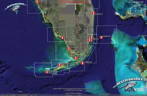
DestinSharks: Vector marine charts for Google Earth (beta)
Are you a boater or boater-curious? DestinSharks is looking for beta-testers for its latest cool tool — EarthNC, marine charts for Google Earth:
We’ve been hard at work for over 6 months to provide an ‘Earth’ alternative for NOAA ENC vector charts covering US coastal waters. When fully released, DestinSharks.com will offer the full catalog of 600+ NOAA vector charts. Each EarthNC chart features the same elements (buoys, channels, lights, etc.) found in the original ENC files – complete with a custom marine icon set for Google Earth.
Get the details here.
Leica lets TITAN out of the bag
In my inbox just now:
Dear Geospatial User,
Leica Geosystems Geospatial Imaging would like to introduce a technology preview of Leica TITAN: a new paradigm for enabling a network of geospatial users to discover, communicate, visualize and share data and information across an internet-enabled, 3D rich-content forum.
We have selected you to participate in our limited release Technology Preview. This technology preview is an initial release and future updates with additional functionality will be made available on a regular basis over the course of the next four months. Our objective is to receive user feedback and ideas regarding the TITAN product, feature requests and how TITAN can evolve.
Because this is a limited release we would like you to treat this information with confidentiality and not re-distribute the product outside of your respective organization. Similarly we ask you not to publish information regarding TITAN on your ‘blog’ or any internet web site until the first official release of the product. We thank you for your understanding and consideration!
Hello Leica. I don’t think we’ve met before. I’m sorry, but you can’t just mass email me a form letter out of nowhere telling me I can’t post its contents on my ‘blog’, especially if it’s sensational-sounding, and especially if it means I’ll definitely find out about it through other channels. It doesn’t work that way. Send me a personal email, or else first ask me if I agree to your terms of confidentiality. If I give you my word, I’ll keep it. OK? Otherwise, I have readers to feed.
And no, you can’t unilaterally embargo information for FOUR months.
The rest of Leica’s email is below the fold. I’ve taken out the download link because I’m fundamentally a nice person. [And yes, I’ve considered the possibility that this is a viral marketing ploy.] So, then,
What is Leica TITAN?
Short news: Panorama Viewer; Google Spreadsheets 2 KML
- Andrew Hudson-Smith has a really cool preview of his upcoming Panorama Viewer for Google Earth (complete with YouTube video). This is a must-visit link. I can’t help but wonder if this is the sort of thing that’s in store for the Google-Pennsylvania Civil War project announced last week.
- Valery Hronusov demos an undocumented feature of Google Spreadsheets. Just as EditGrid does, Google Spreadsheets now also lets you access specific cells or a range of cells via a URL and have it display as text. The secret is to append “&output=txt&range=a1:b3” to the URL of a spreadsheet, where the range of cells to display is A1 to B3. Just put “&range=a1” if you want to display just one cell — which is precisely what Valery did to produce KML from a Google Spreadsheet.
How? Just as with his early experiments using EditGrid, Valery put the shell of a KML template in cell A1, and then used the CONCATENATE function all over the place to build valid KML markup from cell-based data.
Here is his sample spreadsheet.
Here is the contents of cell A1 as a textfile.
Here is that output stuck into Google Maps (as one does).
Google Spreadsheet still doesn’t have EditGrid’s more advanced features: You can’t get your spreadsheet as XML, nor can you apply an XSLT stylesheet to it to convert it to KML systematically (like this). But, says Valery, the one main advantage of Google Spreadsheet is: “It is fast!”
- On a Related matter — Valery Hronusov was at the AGU in San Francisco last week, and he has just put his photos from the event up on Flickr. Here he is with Alan Glennon (of Geography 2.0).
- Looks like there is a Virtual Globes Symposium in Massachussets on January 19. NERCOMP: Virtual Globes: GIS 2.0 (Via GIS@Vassar)
SpaceNavigator in NyTeknik top list, gets competition
How is the 3D controller market looking these days?
Here in Sweden, just a week after 3DConnexion’s SpaceNavigator got a glowing review in the Swedish Geek bible, NyTeknik, it makes it to position number 5 in that publication’s list of the year’s top 12 products, out today.
That’s quite a feat — number 2 on list is the pistol-grip battery-operated torque meter used by Sweden’s first astronaut, Christer Fuglesang, during the current Space Shuttle mission. SketchUp also makes it to the list, no doubt because the reviewer finally started playing with it using the SpaceNavigator. And given that my MacBook Pro is also on the list, I’m feeling rather special right now. (No, I’m not responsible for the list:-)
Also today, news of competition for the SpaceNavigator. Sandio has a press release out announcing the VisonTek XG6, which is primarily aimed at gamers. It sounds promising — apparently it works with Google Earth out of the box as well:
With the new VisionTek XG6 mouse, PC users are now able to move along and rotate about x, y, and z-axis, action that requires users to work with multiple keys on the keyboard or an on-screen navigation bar when using a traditional mouse. The VisionTek XG6 mouse allows PC users to move freely on Google Earth, Google SketchUp, and all PC games. VisionTek XG6 also employs high precision laser sensors and offers users greater flexibility through multiple dpi: 400, 800, 1600 and 2000.
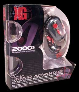 The product website shows you what the packaging will look like, and there is a graphic that shows (sort of) how to the mouse is supposed to let you navigate with six degrees of freedom. It doesn’t seem to be on sale yet, and there is no word on price.
I am of course perfectly willing to review a VisionTek XG6 should it show up on my doorstep, but until then, they’ll have to pry my SpaceNavigator out of my cold dead hand.
GeoServer 1.4.0: The view from Google Earth
Chris Holmes, GeoServer’s lead developer, writes in with details about GeoServer 1.4.0, now fully released:
From the perspective of Google Earth, the improvements we’ve had since 1.3.x with KML are a few fixes for better styling, and better naming of files when one downloads KML from GeoServer.
But although there’s not a ton that’s Google Earth specific, the rest of the push for 1.4.0 was to migrate to Spring for the core. This is the first step in making it easier for programmers to build interesting services on top of the core functionality (ability to read from Shapefiles, PostGIS, Oracle Spatal, ArcSDE, ect. in to a common programming model, and output that to different formats), any of which will be available as streaming KML/KMZ.
The next release (1.5.x) will add some very good raster support, and we’re going to be looking in to doing super overlays from rasters with no additional configuration (including caching them for great performance). And eventually vectors as well, but they are a bit more challenging if you’re doing anything more interesting than just turning all the vectors in to a raster.
I love it when a post writes itself.
Virtual Italia 3D
How I love competition. Windows Live Spaces announces that Virtual Earth now has all of Italy in high resolution, beating Google to the punch. No doubt, this is a direct result of the deal with Norway’s Blom (blogged here) a company that has quite an inventory of Italy imagery (and which provided the bird’s eye views over several Italians cities released last week.)
Something caught my eye: The third-party imagery used by Microsoft for Virtual Earth does not come with copyright statements from contributing companies — all it says is “© 2006 Microsoft Corporation”. I wonder if this costs a lot more? Remember, too that the Blom agreement allowed for its imagery to be used at work — there is no constraint on using Microsoft’s Virtual Earth 3D at the office. I’m guessing that Microsoft is paying handsomely for all this “smoothness”.
With Google’s purchase of Endoxon yesterday, it really seems like the battle for Europe is heating up between these two giants.