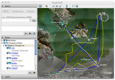
Yachting enthusiasts have long had recourse to sophisticated navigation software. I’m no expert, so when the makers of GPSNavX ($60-$100) let me know that they’ve added the ability to export a boat’s routes, waypoints and tracks to KML (so “friends and family can easily see your plans and progress with Google Earth on a Mac or PC”) I felt I needed to delve a bit deeper into this software niche before being able to have an informed opinion. Luckily there is a recent (Sept 2006) in-depth comparison by Practical-Sailor.com between all currently shipping navigation software, including the market leaders MaxSea and Nobeltec’s VNS.

Surprisingly, after more than a year since the launch of Google Earth, none of these other products mention exporting to KML on their respective websites (though some do export to GPX). Even more interesting is that GPSNavX gets a top rating in this article, is by far the cheapest, and is the only one of the bunch that runs on a Mac. In fact, you can buy a Mac Mini to go with the GPSNavX and still come out cheaper than the other software-only PC packages.
In addition, GPSNavX’s makers promise you will soon be able export GRIB weather files (the WMO standard) to KML. If all this sounds too good to be true, there is a free demo with sample chart, so try it out yourself if you’ve got a boat — admittedly, my desk didn’t travel very far while I played with the software.