Ivan SerezhkinAnonymous, he of Gaia, [Ivan is the hoster]posts his correspondence with Google Earth CTO Michael Jones online (with Jones’s permission). “Please note, that I did it on my own will, not being treated or something. Please do not consider me a victim. Michael explained the possible outcome of my work pretty good.” Indeed.- Marketers for Liverpool, Birmingham and Manchester are “disappointed” that London gets to have all the updates in Google Earth. They get both the BBC and the Guardian to write about it. Says the BBC:
Jenny Douglas, planning director of Liverpool Vision, said: “The current Google Earth images show roofing work still under way at Lime Street train station.
“This work took place between 2000 and 2001, which means the Google Earth images are at least five years old.
“The city centre has changed dramatically since then. It is important that the millions of people using Google Earth have access to the latest images showing the city’s transformation.”
Liverpool, which marks its 800th anniversary as a city next year, is facing a battle to win over hearts and minds before it takes up its role as Capital of Culture. ‘Google Earth is a fantastic search engine I use all the time,’ said Douglas. ‘That is what makes it really disappointing that it seems so out of date. ‘
Google has a novel response:
Rachel Whetstone, a spokeswoman for Google, said that the site relies on third-party external companies to provide their pictures. ‘We can only update things as soon as we have the data,’ she said. ‘We want to give people the best service we can, and so not doing it for London just because we can’t do it for other cities would seem wrong.’
Much better to have this problem than a situation in which people are calling for censorship, or — even worse — nobody cares.
Monthly Archives: November 2006
Google Earth, tool for social change in Bahrain
The Financial Times on Friday published the kind of article that should make the Google Earth team proud:
Google Earth spurs Bahraini equality drive
By William Wallis in ManamaSince Bahrain’s government blocked the Google Earth website earlier this year for its intrusion into private homes and royal palaces, Googling their island kingdom has become a national pastime for many Bahrainis. […]
A senior government official told the Financial Times that Google Earth had allowed the public to pry into private homes and ogle people’s motor yachts and swimming pools. But he acknowledged that the government’s three-day attempt to block the site had proved counterproductive.
It gave instant publicity to Google Earth and contributed to growing sophistication among Bahrainis in circumventing web censorship.
It also provided more ammunition to democracy activists ahead of parliamentary elections this Saturday, the second since King Hamad bin Issa al-Khalifa began introducing limited political reforms in 2001.
It gets better after that, with plenty of props to Mahmood Al-Yousif. (For earlier coverage of Bahrain on Ogle Earth, look here: Bahrain bans Google Earth, Bahrain: Censorship redux and Bahrain in Google Earth, unplugged.)
What Belgium thinks of Google Earth
Belgeoblog digs up a long passage about Google Earth in the 2005 annual report of the Belgian intelligence oversight committee.
Most of it was written in late 2005 by specialists at the request of the committee. Google Earth was still new then, and the report (aimed at technoclueless politicians) spends a lot of time explaining what Google is and how Google Earth works, often in a rather confused fashion. But here’s part of the conclusion, translated from Dutch:
The technology behind Google Maps and Earth is not new and not unique (for example, Keyhole). [Sic. The author is apparently unaware Google bought Keyhole.] […] What is new is the name recognition of the company, the breadth of the material and the high level of detail of some of the photos. […]
Anyone who wishes to acquire a satellite image of a spot on Earth can do so via a number of commercial providers. These providers are primarily American, European and Asian. This has been possible for many years, without limitations, and it is possible to acquire quite recent photos of good quality at high prices. Google Earth offers but a restricted set of archival photos from a large American provider (Digital Globe). [I don’t think it was ever the case that only Digital Globe images constituted the high resolution dataset of Google Earth.]
Google Earth only offers images that are not entirely precise geographically, and which are not rich in information of the kind that can be found in images that are purchased directly from a provider. [True, if “not entirely precise” means tens of meters.]
Being in the possession of a satellite image is one thing. Analysing it to obtain specific information is a different field altogether, requiring much training and expertise, and also intelligence obtained from different channels.
In sum, we are of the opinion that the publication of satellite imagery to Google Earth is a wonderful commercial operation that will give some people the incentive to purchase photos from the provider (Digital Globe), that will widen access to a specific kind of information that has existed for years, and that will popularize many potential applications for satellite imagery. None of this is new to those who in the past have tried to acquire this kind of information. A piece of intelligence is something else than a pretty digital photo.
This does not mean that our service does not worry about the fact that such photos circulate on the internet, especially on the pay version of Google Earth ($400 per year) which offers “recent” images that are a few hours old.
That concluding paragraph is just bizarre — Google Earth Pro offers the exact same dataset as the free version, and Google has yet to add images that are just a few hours old. The closest we’ve come was the Katrina and Pakistan quake imagery, available to all, which was a few days old.
Meanwhile, the quantity and quality of the imagery available of Belgium in Google Earth has improved, which prompted calls for yet another study by the same committee in September of this year, with the results due two months ago. Nothing more has been heard publicly from the committee since.
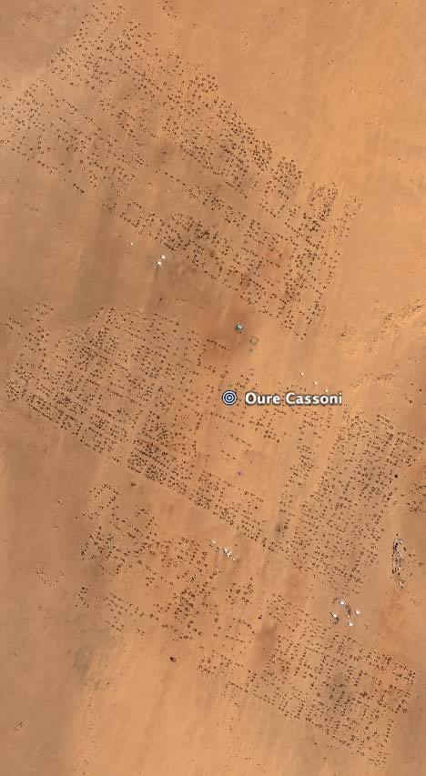
Darfur: Refugee camps in Chad now in high resolution
The update to Google Earth’s imagery dataset on Nov 23 puts some of the major refugee camps on the Chad side of the border with Darfur in high resolution. Here they are. (Source)
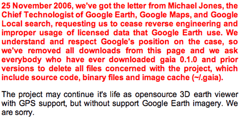
From Gaia with love
Gaia is was “an attempt to reverse engineer famous Google Earth and implement its functionality in open, portable, customizable and extendable way.”
Ivan Serezhkin Anonymous from Russia [Ivan is the hoster], has been working since May on harnessing Google Earth’s encrypted imagery for his own map and virtual globe. He went live with it in October, and it managed to fly under the radar until it hit Digg.
The problem? Licensing. Gaia’s home page now sports this:
What’s interesting is the reactions that followed, ranging from the downright sophomoric to quite a few spirited defences on Digg of Google’s right/obligation to protect its licensing agreements with vendors.
World Wind blog The Earth Is Square takes another tack:
Nice to see that Google is keeping on the ball with “Thou Shall Not Use GE Imagery Outside of a Google OK’ed Medium”. Which is a “Bad Thing” because people don’t realize that giving their imagery to Google means you can only view the imagery with what Google says you can view it with. Which takes the imagery out of the public domain.
In the comments, KoS takes issue with what constitutes “taking imagery out of the public domain”, and I agree. To wit: Google’s dataset is a mix of public domain and licensed imagery. The public domain imagery is a copy of data that is available elsewhere. Google doesn’t take it out of the public domain by duplicating it on its own servers. It couldn’t even if it wanted to, as the original source of the public domain data is out of Google’s control.
But this brings us to another issue: It’s not just a licensing question: Google is serving data via viewer applications and APIs. That’s a service which costs Google money, which it has built, owns and to which it can restrict access. Hence the EULAs we agree to, including when something is free. It’s my understanding that even if all of Google Earth’s imagery were public domain, Google could still restrict its use when served from its own servers. The same principle applies to NASA World Wind’s base dataset — otherwise, who would pay if a very popular web service were to start leeching off World Wind’s servers? US taxpayers? Would NASA be obliged to upgrade its servers to stop World Wind’s performance from being degraded? That would be absurd. Instead, you would ask the leechers to stop.
Short news: SketchUp for Education, Killing my Lobster, rollnzoom
- Infinite Thinking Machine has a cool video interview with Google’s Aidan Chopra, program manager for SketchUp for Education. Chopra is very articulate and the video is easy on the eyes, with good commentary on how SketchUp can be used in the classroom. Chopra promises lesson plans.
- You might think KML stands for Keyhole Markup Language… but in my newsreader, searching for KML also often brings up the doings of a certain comedy troupe &mdash Killing My Lobster, aka KML. Fancy a KML T-shirt? It is so unintentionally geeky it comes right back to being cool again. (Next week in the Misadventures of My Newsreader: Teaching people the difference between Whirl Wind and World Wind.)
- EditGrid vs. Google Spreadsheets vs. Excel.
- Yet another satellite sightseeing site: rollnzoom. It’s quite Web 2.0-ish, though, with support for tags, users, themes and — this is new — browsing by when when submitted. Individual items can then be viewed on a variety of maps, including Google Earth and Maps.
- Frank Taylor flags two interesting KML files: layers mapping economic data made by Maplecroft, a CSR and risk management consultant. (Their flash-based browser version also adds interesting source and reference material, great for educational purposes.) Frank also points us to layers showing the “exclusive economic zones” of each country in the oceans of the world — where countries have special rights to the marine resources there.
- Nice video by Bull’s Rambles shows off sun shading in NASA World Wind.
- Valery Hronusov’s Superoverlay reaches version 1.4.3, which includes the ability to select areas with the cursor. All of Valery’s software projects are now accessible from his new site on Google Pages, Google planet.
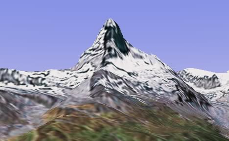
Google Earth improves height mesh, updates imagery in time for Thanksgiving
Ah, now here is something to be truly thankful for: An update to Google Earth’s dataset. And not just to the imagery — to the height mesh as well. Check out the Matterhorn in Google Earth now:
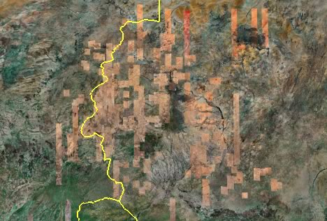
And the Darfur region gets comprehensive high resolution coverage, which will make the work of humanitarian agencies easier while at the same time make it harder to deny the carnage going on there:
PenguinOpus posted the complete list of improvements to the Google Earth Community BBS here:
This morning, a terrain update occurred that corrects many of the holes in the SRTM data. This greatly improves the appearance of Mt. Everest, Matterhorn, and others in South America, Asia, and Europe.
Also included are imagery updates:
- 12 high-resolution cities in Germany (Bayreuth, Bochum, Castrop-Rauxel, Fulda, Hof, Mannheim, Marburg, Potsdam, Schweinfurt, Siegen, Unna Froendenberg, Wuerzburg)
- 6 high-resolution regions in the UK (Bridgend, Cleveland, Dundee, Plymouth, Poole, Rochford)
- 31 city updates from Digital Globe
- entire island of Oahu
- Imagery from individual cities/counties: Grants Pass, OR; City of Kent, WA; Salem, OR; Douglas County, WA; Hartford County, MD; Jackson County, OR; Summit County, OR;
- Expanded/updated coverage for the states of Massachusetts, Rhode Island, Indiana, and Florida
- Darfur
- 66 Islands
- improved SF/Bay area water