Happy blog birthday, Declan, and you celebrate with insightful news. I too like the idea of Amazon’s EC2 computing-on-demand service — like Amazon’s S3 storage on demand, but where you rent processor cycles rather than networked storage. What I think it would be really useful for is server-side analysis tools for Google Earth, feeding network links.
In other words, the PHP scripts that I have running on my server for solving the traveling salesman problem in Google Earth or for finding the center of gravity could scale if they were run on EC2 (which might be necessary if they actually did something useful). And at 10 cents per computing hour, it would take very few clicks on Google ads to make this sustainable.
I’m wondering also if the open-source GeoServer might not work on this service. (Perhaps somebody already has managed to?) And since Google is very much into keeping content created for its applications in one place, semantically marked up and hosted for free (Google Earth Community, Picasa Web Albums, Google Spreadsheets), I can definitely see the logic for them in also hosting processes that enhance Google Earth.
Chris Holmes, who develops GeoServer, gave a TechTalk at Google in August. GeoServer already streams KML with code funded by Google. Might it not make a great platform for hosting services for Google Earth, on a Google version of Amazon’s EC2, free and ad-funded? I’m just speculating, but it would be really cool.
As we’ve been told repeatedly this week, ArcGIS Explorer does not want to compete with Google Earth because AGX exists primarily as a client for ArcGIS-created services and tools. But that doesn’t mean Google Earth can’t compete with ArcGIS Explorer by expanding into that market by harnessing open source apps like GeoServer.
Two GPS community sites were brought to my attention almost simultaneously today. Both allow you to upload, edit and share GPS data, and both offer exporting to KML.
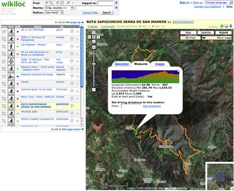
First up: Wikiloc, by Jordi L. Ramot. Jordi writes up his site far better than I can:
I’ve recently developed a completely free web app to discover, post and share GPS information on the web. Posting a GPS tracklog/waypoint (in gpx format) takes less than a minute and immediately you can visualize it on Google Maps, in 3D in Google Earth, you get the elevation profile, distance, accumulated heights, driving directions to the trail head, attach pictures too. For GPS trails in zones with Web Map Services registered in Wikiloc, you can even visualize them overlaid on USGS (or Spain’s ICCs, etc…) maps both in 2D (Google Maps) and since yesterday in 3D (Google Earth) too (I’m pretty excited about the latter and I’ve written about it in my latest weblog post).
Wikiloc won the Google Maps Mashups contest prize some weeks ago and since then it has had good acceptance from users, at the moment mainly in southern Europe although there are already some authors from the US like hikerdave. I’m surprised and glad that my little web app is being known in other countries too. So far all user feedback has been great and I’d love to let the app be known in other countries.
Glad to help:-)
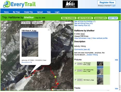
The other GPS sharing site is Everytrail: Here too you can upload GPS files, add waypoints, photos, notes… and then share them. In addition to exporting the edited track to Google Earth, you can also add it to your website via an embedded iframe. Another nice touch: If you have a PC, you can download a client that will automatically transfer tracks from your GPS device to EveryTrail online. And, of course, it’s also free.
The person behind EveryTrail is Joost Schreve, who explains the motivation behind it in an interview with Tech Digest:
Everytrail has its roots in founder and CEO Joost Schreve’s own travels around the world, and frustration at the fact that it wasn’t easy to share his photos and experiences online. Having created various websites and blogs, he and his friends decided there must be a better way. Hence Everytrail.
The whole thing is an interesting read. (I found EveryTrail via Jeepx.)
And a few weeks ago, Ogle Earth wrote up Crankfire, a GPS community site for bike trails. So now there is Wikiloc, EveryTrail and Crankfire. I think we have ourselves a promising new genre of community site here. Check them all out.
Got Mac? Then check out this widget: 3D IP Lookup. Type in a URL, get the path from it to you served as KML. The KML still needs some polishing (hint: tessellate=1), but it works as advertised.
What has Valery Hronusov been up to this week? Leveraging the ability to put EditGrid spreadsheets and charts on any web page, updating them live inline, and seeing the result instantly in a network link. Amazing potential here.
Juicy Geography was also one of the lucky early recipients of a SpaceNavigator, and also gives it a positive review: “Younger test subjects (i.e. my 12 year old daughter and friends) have responded with huge enthusiasm.”
So ESRI ArcGIS Explorer is also opting for the soft launch — either that, or it is putting its trust in security through obscurity, which in the age of blogs is rather optimistic. James Fee shows the way: Follow this link to the download, though you will first need to set up an “ESRI Global Account”, which I did without problems or needing to use credit card info.
First impressions of ArcGIS Explorer? Hmm:
I guess I had taken it for granted that in virtual globes text info would simply face me, especially as both Google Earth and NASA World Wind manage to do it, and since the whole point of having a virtual globe is that you get to choose the perspective. But now Microsoft Virtual Earth and all the “globes” I’ve tried in ArcGIS Explorer put their labels in rasterized layers that assume you’re facing North and looking straight down at the ground.
Imagine if that’s how Second Life worked with labels and such — always horizontal, facing North. You’d go bonkers. Instead, they face you. Why would information dissemination on a virtual globe be any different? Either because it is difficult to do, or because old thinking about maps continues to dominate the new technologies for viewing geospatial information. A virtual globe, just like a virtual world, should be about you.
I haven’t had the time to get much more of an impression of ArcGIS Explorer, so that will have to wait for another post. Data loads relatively slowly at the moment (maybe because servers are still not ramped up) and navigating across the poles is equally screwy as in Virtual Earth (and, BTW, NASA World Wind.) People, there is nothing special about the poles. Why can’t I drag myself across them? Planes do it all the time in real life.
Here’s a short interview with Rory Dooley, president of 3DConnexion. I sent him some questions on the occasion of the launch of their new 3D motion controller, the SpaceNavigator, aimed at the consumer market (and reviewed here.) Below the fold, I ask him about 3D operating systems, the pricing model and the upcoming software development kits.
Ogle Earth: How come nobody’s made a cheap one of these before? Are they more expensive to make than mice? Has the potential market been too small?
For the past month I’ve led a double life. It all began when Rory Dooley, president of 3DConnexion, got in touch to let me know he’d be passing by Stockholm, and could he show me a new consumer product they’re developing that works with Google Earth? Obviously I said yes, and thus I soon got to know the SpaceNavigator. The catch: I couldn’t write about it until today.
If you don’t already know 3DConnexion, they’re a subsidiary of Logitech, and they have built their reputation making high-end 3D motion controllers for professional CAD applications. Many CAD pros use these controllers in their left hand to maneuver the 3D environment in which they work, and then use an ordinary mouse in their right to manipulate an object (if they’re right-handed). These controllers have traditionally been expensive, low volume items, aimed at a small market of professional users.
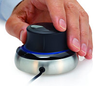
Until Now. The SpaceNavigator Rory demoed is a brand new such device, but is aimed primarily at consumers. Just like the pro models, it works by letting you maneuver a control “stump” through six degrees of freedom: Push along the X, Y and Z axis to pan, and twist along the X, Y and Z axis to rotate. (There’s two ordinary mouse buttons as well.) If you’ve ever played with the red nipple at the center of an IBM Thinkpad keyboard, then you’ve played with a very primitive (2 degrees of freedom) implementation of this concept.
But the SpaceNavigator is not just a piece of hardware. It comes with a driver (Windows XP, Mac promised) that integrates this device seamlessly with both Google Earth and SketchUp. An SDK is coming in a few months, says Rory, so many more 3D applications can soon be made compatible. Clearly, the SpaceNavigator is intended to capitalize on the burgeoning popularity of consumer 3D applications.
But does it work? Oh yeah. After about 2 minutes my left hand disappeared and I began to mind-meld with Earth. Think Rotate and that’s what Earth does. Push in and you zoom in. It’s a completely new level of control, and it’s completely addictive. The sensitivity is proportionate to your altitude, so at sea level you can work with sub-meter precision. Zoom out and you can traverse the world in a second. Look up above the horizon if you like, or pan, zoom and rotate all at once. You can make yourself queasy without trying very hard.
But in addition to the ease of use, there are three things about the SpaceNavigator that stand out:
It’s beautifully designed. It’s the only thing that dares approach my MacBook Pro without breaking into a blush.
It’s solidly built. The brushed metal circular base is heavy, so you can pull at it without lifting it. The controller itself offers good resistance.
It’s cheap. $60 (‚Ǩ60) if you’re a home user, $100 if you’re a pro. That’s the same price as my “ordinary” 2D Logitech mouse, and it’s a fraction of the price of all the other 3D motion controllers 3DConnexion offers.
Now for the full disclosure bit. Although I would have bought one, Rory gave me one to play with. I have thus been using the SpaceNavigator for a month at home. While I applaud 3DConnexion’s marketing savvy for incorporating niche blogs in their launch campaign, I’m pretty sure this hasn’t biased this admittedly glowing review. I just really like it.
For a sense of the maneuverability you get in Google Earth, here are two videos I made. The first shows me careening through Wall Street, the Grand Canyon and the Golden Gate Bridge. The second shows off some close maneuvering around the Eiffel Tower. I used the SpaceNavigator in my left hand for both. (I’m right-handed.)
Some more notes:
I’ve also tested the SpaceNavigator on friends in the intervening month. They all take a few minutes to get their bearings, and then they tend to get possessive with the computer.
Rory said they’ve made a batch of 50,000 of these. At that price point, I suspect they will run out. 3D is the next big thing for computers — even operating systems are going 3D — and I think that this trend will facilitate new ways of navigating. 3DConnexion has an obvious head start. Google Earth now also works with a number of joysticks and flight simulation paddles, but none of these have the six degrees of freedom that SpaceNavigator has.
I’ve also played with SketchUp a little using SpaceNavigator. There is an interesting distinction here: In Google Earth, you maneuver yourself in relation to the Earth — because Earth is big and you are not, so this feels natural. In SketchUp, you maneuver the object, and you remain stationary — i.e the controls are reversed. This is how CAD people use it, but it takes some getting used to if you predominantly use SpaceNavigator to surf Earth. [Update: You can of course change these settings — these are merely the defaults.]
3DConnexion also came out with a more expensive new pro model today: The SpaceExplorer ($300).
Pros can buy the SpaceNavigator for $60 to play with it, and then buy a $40 upgrade online if they decide to use it for work. It’s the same machine and software. What’s different is the support offered.
You can also read a short interview with Rory Dooley.
[Update 10:35 UTC: Gizmodo unwraps one and takes som pics.]
Noted: Google Earth Community these days also lets you see uploaded KML files in Google Maps via a link. Here’s how it looks for the Darfur refugee camp post. (Google Maps hasn’t been updated yet at the moment, so you get to see what the low-resolution imagery looked like before.)
All Points Blogpoints to The Hindu reporting the further utterings of Indian president A P J Abdul Kalam to the effect that there should be laws that regulate the use data acquired by satellites:
“We have to have a law of space like the United States,” Kalam said addressing the 26th Congress of Indian National Cartographic Association (INCA) here.
It’s not clear if he knows what he’s talking about, because US law only applies to US companies seeking licenses from the US government to launch and operate remote sensing satellites. If Kalam wants to regulate Indian satellite operators, he’s very welcome to, but I suspect that’s not what he had in mind; India has on several occasions made it clear “there should be an international agreement that before satellite pictures are taken over a particular country, the permission of that country has to be taken.”
 Until Now. The SpaceNavigator Rory demoed is a brand new such device, but is aimed primarily at consumers. Just like the pro models, it works by letting you maneuver a control “stump” through six degrees of freedom: Push along the X, Y and Z axis to pan, and twist along the X, Y and Z axis to rotate. (There’s two ordinary mouse buttons as well.) If you’ve ever played with the red nipple at the center of an IBM Thinkpad keyboard, then you’ve played with a very primitive (2 degrees of freedom) implementation of this concept.