Digital Distributed Environment‘s Andrew Hudson-Smith applied textures to a model of a row of houses in London, using his own in-house software to ensure accurate scaling of the photographs. The result, viewed in Google Earth, is very cool, and it’s a precurser of what we can expect to see much more of:
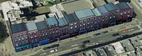
I especially like how the signs and awnings are rendered in 3D and textured. It’s a lovely touch, and it is easy to imagine walking along this street:

My other initial impression is that this technology is going to provide a potent new weapon in the “eye candy wars” that Google and Microsoft are informally engaged in. Live Local’s “bird’s eye view” imagery can’t compete with such imagery pasted onto true 3D models. We’ll have to wait and see how Microsoft leverages its purchase of Vexcel and Geotango in response.
Andrew asks for feedback. In my case, Google Earth 4.0 Free for Mac handled the file well, after one initial crash and then a bout of the hiccups that cleared up by itself. Just don’t forget that GE4 is _beta_; it sometimes stalls for me on other files as well.
It’s like living in Half Life 2!
Weren’t google driving around San Fransisco photographing/scanning all the buildings? Will this data start to appear soon?
Never mind Google, we have Street Level View already, check out….
http://www.novaloca.com/blog/index.php/2008/10/17/view-londons-commercial-property-in-street-level-view-with-novalocas-maps/