Remember how in The Perfect Storm Sebastian Junger writes evocatively about the sea buoys out in the Atlantic ocean and how they come to record amazing wave heights? Now you can monitor these very same buoys in near real-time in Google Earth, and much more besides.
The network link that makes this possible is the work of Jeremy Cothran at the University of South Carolina’s Advanced Solutions Group. He’s posted details on Google Earth Community. The file is a direct download here.
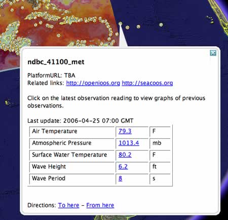
What I find especially nice is how if you click on a buoy’s current wave height data you are taken to a web page that shows you a historical data series. This works for any data point, in fact.
And the network link actually covers both ocean- and land-based measurement platforms across the western hemisphere. This is truly the sensor web in action, and how.
Hi,
Just wanted to post some additional technical links for others who might be interested.
Adding more of the same datatypes from other platforms is fairly straightforward if others are interested in adding more data points or reproducing this type of system in whole, send me an email at jcothran[at]asg.sc.edu.
We’ve done a fair amount of open source documented development work setting up aggregations of near real-time data flows ( http://nautilus.baruch.sc.edu/twiki_dmcc/bin/view/Main/SEACOOSCookbook2 ) for in-situ and model output using a netCDF convention. I would like to create redundant type server setup and data feeds perhaps packaging the software to something like knoppix ( http://en.wikipedia.org/wiki/Knoppix ) that would allow other developers to try/demo the software before installing to a server. A very basic system and software is discussed here ( http://nautilus.baruch.sc.edu/twiki_dmcc/bin/view/Main/MultiObsSchema ) . I’m also working with another group to try and better define XML schemas and some basic common web services ( http://twiki.sura.org/twiki/bin/view/Main/OosTechServiceDefinition ) which seems to be moving towards adoption of the OpenGeospatial Consortium Sensor Web Enablement ( OGC SWE ) schemas and specifications ( http://www.opengeospatial.org/functional/?page=swe ).
Would be interested in sharing development ideas, code with any developers or teams that have more time/ability to refine/package these system components for free and open source use.
Thanks again,
Jeremy