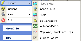
 Just noticed that photo geocoding app RoboGeo is up to version 3.4 — it can now export your GPS tracklog as AutoCAD 2000 DXF files (in addition to doing ESRI shapefiles, blogged previously).
What’s so special about DXF files? SketchUp supports them. This leads to some interesting possibilities. Thinking aloud, you could, for example, take geocoded pictures of existing buildings, and then try to recreate those buildings inside SketchUp using your tracklogged image locations as vantage points, for comparison. (Caveat: I haven’t tried this.)
Should I be anticipating an ‘orientation’ header as an EFIX header, or for practicality, would we first need a digital camera with built-in compass? This would surely open the door to some very intelligent behavior.
Orientation and tilt would be great!
This is just what we’ve been waiting for! Up to 3.4! When is 5 coming?
We are going to test how to make use of this great for creating 3D site and buildings views based on location photography.
For related matters, visit our http://visualcuriosity.blog.com/GeoDesign
Jerome
M3D Glider Team