GETrack: GPS to Google Earth via Java

GETrack is a free java application for those with both a Nokia Series 60 phone and bluetooth GPS receiver. It generates KML files with positions at varying intervals which you can then download to the PC via bluetooth.

That makes the whole process rather painless, no?

walk.jog.run does Google Earth

walk.jog.run, a site where you can share your jogging routes as well as calculate distances and times, now also lets you export routes to Google Earth.

[Update: 9:49 UTC: Mre details here, on the developer’s blog.]

KML gets a better reference, integrated with PHP

Some major talent’s been hacking Google Earth’s KML. UK-based TJ has come out with four separate feats of programming derring-do, listed here in order of increasing, well, impressiveness:

1) GE Traceroute: This has been tried before, but TJ’s version also lets you edit locations in the traceroute for accuracy, via an ingenious system that uses Google Earth as the interface. It’s available for commercial licencing.

2) TJ’s Global Nuclear Explosions Database: Yes, this database contains every known nuclear explosion, listed by date, yield, time, country, altitude, and of course, coordinates. Results can be filtered and then viewed as KML placemarks.

3) A better KML reference than Google’s own: That’s because TJ lists undocumented tags as well. (Why aren’t these in the official KML documentation?) Copious exampes illustrate howw the tags are used.

4) KMLDocument for Google Earth: As TJ writes, “I’ve developed a comprehensive KML package for PHP 5 that creates and manages KML XML documents, and can output KML plain text or KMZ gzipped data.”

Details of this beta: “The classes provide each KML element with its own createXXXX() method, has composite buildXXX() methods for building common tag structures (Placemarks, NetworkLinks, etc.), and has convenience methods such as buildIcon(), drawRectangle(), drawCircle(), drawEllipse() and so on.”

It will soon be released for Java and C++ as well, and you can email TJ if you want to help beta-test the PHP package.

What Would Java Do? WW2D usage notes

I’ve been playing with WW2D, a cross-platform Java-based open-source Google Earthish application that works on OS X and Linux (and Windows), and here are some usage notes:

Installation is a cinch. Instructions are crystal clear. Whatever Java machine comes with OS X 10.4.3 works flawlessly.

Wait, this is Java??? WW2D is extremely responsive, even on my aging Mac, and the zoom controls are so fluid that I found myself zooming in and out far more often than I needed to. Image tiles are fetched from the internet on demand (much like Google Maps) but navigating the map is far faster and more responsive than any 2D web-based app I’ve used. It never crashed.

WW2D isn’t 3D, of course, so no tilting and no globe, but when you’re zoomed in close, it feels like Google Earth.

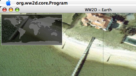
The data set is not bad. It renders the entire contents of Blue Marble Next Generation. Closer in, the world is covered by Landsat 7 imagery, which in many places is as good as Google Earth gets. In the US, you have access to the USGS imagery, which Virtual Earth uses. But the rarest (and most fun) is the layer labeled Aerial orthophotography. You don’t know if you get to see anything from this layer until you zoom in close, and there isn’t much available, but do start with Long Island, as it is covered in its entirety. Fire Island especially has some amazing villas on it:

fire_island.jpg

The main downside vis-√Ü-vis Google Earth, other than the lack of 3D, is that while there are “add-ons” with additional data available for WW2D, there is nothing similar to the network link, and its absence makes you realize to what extent Google Earth’s usefulness is derived from it. Without the network link, you don’t really have a killer app (hence NASA World Wind’s relative obscurity).

WW2D’s GUI is a very sparse, but I came to regard this as a zen-like feature, not a bug. As long as there isn’t a 3D globe application out for the Mac, WW2D belongs on every Mac-owning map aficionado’s desktop, purely for its usefulness as a speedy Landsat 7 imagery browser. All the rest is a welcome bonus.

Earth unplugged

The following story has nothing to do with Google Earth other than the slant it’s been given by the Times of India: “India’s answer to Google: Image Atlas

Image Atlas will show the globe at a resolution of 2.5 meters per pixel with pictures taken from Indian satellites. It will be published next month by India’s National Remote Sensing Agency (NRSA). Adds Times of India:

Mindful of the concerns about Google Earth maps raised by President Abdul Kalam last month, NRSA’s bouquet of high-resolution images will not carry features of defence installations and, therefore, be of no use to the enemy.

Cute. And did I mention that Image Atlas is a 212-page book?