From the maker of FlickrFly comes UKAutumnColour. Rob Roy has created a network link that scrapes a UK Forestry Commission page for current foliage colors across the country and displays them in Google Earth.
Monthly Archives: September 2005
A2E, meet KHC
Matthew Hampton writes in:
I am a GIS analyst/cartographer and am very interested in the translation of GIS data into GE. The forthcoming A2E script looks very promising, but presently it looks as though the “KML Home Companion” script is coming along as well. I don’t know if A2E is going to cost money but KHC (or KMLHC?) is open source. [Jim Cser] just released v2.0 and finally supports re-projections.
Thanks Matthew for the heads up. I see James Fee also has a post up on this. Unfortunately, given the complete absence of ESRI’s ArcGIS 9 on my desktop, this is the point at which the pros take over.
(Request: Any chance some of you could showcase some of your more fancy work in ArcGIS, exported using these tools? Just so we can get an appreciation of what GIS professionals do?)
The ultimate mashup
Can you mash up both Earth and Maps? Chicago Real Estate broker Prudential Preferred Properties certainly had a go. Writes Chris Janseen:
Thought you might like to check this out – been following the progression of some of the Google Earth uses out there to use in my own and I noticed that Prudential have merged the Google Earth local search directly into their Google Maps — it is pretty nice, good middle ground between the desktop GE app with the added benefit of being built right into the browser. Thought you may want to check out some progress of them.
You need to register to use it, it won’t work in Safari, you have to zoom in tight and there are no local listings outside Chicago, but this Google Map certainly carries some of the features that until now only Earth had. Look:
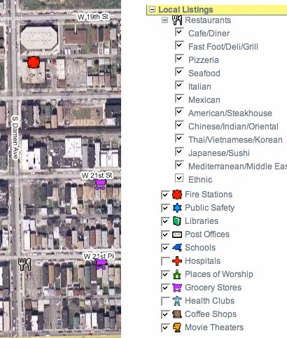
I guess this means the challenge of depicting layers on Google Maps has been solved, at least for placemarks. (Prudential also does a straight-up Google Earth implementation, as explained here.)
Rapa Ennui
I too went looking for Easter Island during one of my first forays onto Google Earth, only to find some of the lowest-resolution imagery in the database. That’s probably because it’s one of the most remote islands around, and in any case the situation can be remedied by overlays, but as France’s Le CyberRider illustrates with screenshots, this is one spot where NASA’s World Wind beats Google Earth hands down. Good to be reminded now and again that there is competition out there.
(PS, I’ve been lucky enough to make it to Easter Island, and I can highly recommend this beach. Truly one of the world’s finest.)
Privacy and Google Earth in Australia
For the first time that I am aware of, a government official “admits” Google Earth raises privacy concerns. The Age reports that while Australia’s Attorney-General Philip Ruddock does not consider Google Earth to constitute an additional security risk just now, “I am aware of privacy concerns raised in relation to Google Earth.”
It’s interesting that this should first crop up in Australia, which has a lot of very remote rural farming. I myself admit that as a life-long city dweller, I don’t much care if the world can see the rooftop of my apartment. Property owners, on the other hand, especially those with large tracts of it, might feel somewhat naked, suddenly.
Even so, property ownership is not the same as an absolute right to privacy. There are many other legal ways of observing private property — from planes, helicopters, clifftops, ladders… Any of these currently provide much better papparazzi possibilities.
(Note to self: Business idea: Sell next generation private satellite imagery of celebrities to Hola, The National Enquirer, Paris Match… and invest in pergola manufacturers.)
Product roundup
MxGPS 9, “a user-friendly application to transfer data between ESRI’s ArcMap application and Garmin GPS,” now lets you download waypoints directly into Google Earth as well.
RealTrack Mobile version 1.5, which allows the tracking of GPS-enabled PocketPC PDAs in real time via GPRS or wifi (using a server), now lets you see your army of users in real time on Google Earth — useful, for example, if you’re managing a fleet. Or, come to think of it, for some cool real-world as-yet-unthought-of strategy games out in the wilderness. Capture the flag, anyone?
Authoring tools for Google Earth?
James Fee lauds Brian Flood’s Arc2Earth (which the cool people already call A2E).
A2E (was that subtle?) is a conversion tool for stuff created in ESRI’s ArcGIS, the Microsoft Office for GIS pros (costing $1,500 and up).
All of which raises a broader question in my mind — let’s say you know nothing about GIS but you’ve been impressed with Google Earth. So impressed, in fact, that you’re inspired to contribute your own creations for the greater good of the Google Earth community. Given the conversion tools now available, what’s the best application to be creative with? What is the cheapest? What is the best value for money?
It’s an open question, and I don’t know the answer. I’m aware of ArcGIS (now with a 60-day evaluation CD), as well as SketchUp, for Windows and Mac, (free trial), Amber iQ (with, you guessed it, a 15-day free trial), Google Earth Pro Beta (7-day trial!) and then I run out of ideas. Could GIS pros be so kind as to help us neophytes with a leg up on the product offerings? Cheapness is definitely a virtue for a first application, given most of us are not about to get a student discount on ESRI GIS software.