NASA: Not Accurate Space Agency

[Update 13:19 UTC: It would now seem that NASA has “resolved” the issue. But I’ve got proof:-)]

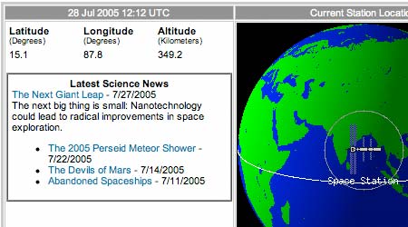
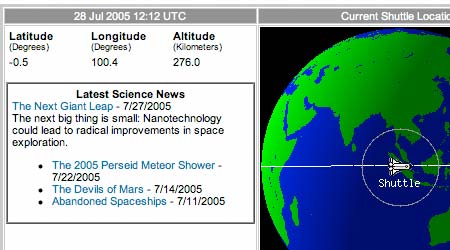
Open up NASA’s page tracking the Shuttle and the one tracking the International Space Station side by side. Notice something? They’re supposed to be docked as I blog this but NASA has the Shuttle ahead of ISS by a whole 5 minutes. Look:

ISS: 12:12 UTC:

iss.jpg

Shuttle: 12:12 UTC:

shuttle.jpg

ISS: 12:17 UTC:

iss2.jpg

The trajectory seems to be the same, it’s just that the Shuttle is leading ISS at a much lower altitude. It’s not an update timing issue, as a whole five 1-minute-interval updates span the difference. So where might they be? At the first location? The second? Are they filming the ISS footage in a studio in LA somewhere?

This explains why the KML dynamic link I uploaded earlier doesn’t have the two placemarks hugging. These are the pages Tom Mangan‘s script scrapes to provide “live” coordinates.

I’m sort of crestfallen. If you can’t trust NASA anymore, who can you trust? What’s the point of offering us civilians data to within a minute of precision if it is provably off by a minimum of 5 minutes?

How to geotag del.icio.us bookmarks

Makezine has a walkthrough tutorial on how to tag del.icio.us bookmarks for display inside Google Earth. Bringing Google Earth experiences to the masses…

Space Shuttle + Google Earth mashup (for real)

In the last post, I linked to a Windows application that generates KML for orbits of satellites. Somehow, this wasn’t satisfactory — it’s a Windows application, so this means it won’t be of use to me when I eventually get to run Google Earth on my Mac.

I came up with another solution, and it involves sitting on the shoulders of Tom Mangan, who created this excellent Google Maps mashup with the positions of both the Space Shuttle and ISS. He wrote some code that periodically scrapes NASA websites for the live coordinates. He was kind enough to lend it to me.

I used PHP to parse the results of Tom’s servlet and wrap it inside valid KML, on the fly. I tweaked the KML so that a line extrudes from the surface of the Earth to the spaceship itself. This gives a good sense of how far up the spaceship is, especially if you’re looking at it from afar. The positions are automatically updated once a minute.

Here is the network link as a KMZ file, ready to launch with Google Earth.

Unfortunately, I did not figure out a way to get Google Earth to fly along with the spaceships, so you’ll have to do some manual maneuvering. Also, if you ask Google to swoosh in on a placemarker suspended 300km above Earth, it instead zooms in on the spot directly beneath it. I suspect this is a bug, as that is the effect I would expect if the placemarker were located on the surface of the Earth, rather than above it.

Then again, I might be wrong, as I am checking this via VirtualPC on my Mac, where the refresh rate of the image is about half a hertz. (Then again, it’s not like I’m trying to play Halo2).

Space Shuttle view of (Google) Earth?

Earthhopper has posted a shot to Flickr of a simulated view from the Space Shuttle, and this Google Maps mashup displays the Shuttle’s position live, as well as its coordinates.

But I haven’t yet found a dynamic network link for Google Earth that updates with latitude, longitude and height, so that we can see exactly what the astronauts see, live. (If I had more time right now I’d whip one up, but work beckons.)

[Update: 18:51 UTC: Earthhopper provides the answer in this followup post. There is a Windows application that fetches the data and produces KML on demand.]

Google Earth does GPX

On his voyage into the guts of Google Earth, Mark McLaren discovers that the application comes with a GPS file format converter called GPSBabel, which means it can load GPX files, the defacto GPS file standard. That will make life a lot easier for those with legacy data they’d like to put to use in Google Earth.

Mark also discovers a lot more about how both Maps and Earth get their data. Definitely worth a read.

[Update 00:07 UTC 2005-07-27: Here is a long list of GPX resources. And here is repository of GPX files.]