- Daily Arctic ice animation: Ross Swick of the US National Snow and Ice Data Center writes:
The near real-time sea ice animation has made it’s way through our review process and been released on our virtual globes home page. It’s much improved as a result of everyone’s feedback. The released version includes both sea ice concentrations and sea ice extent. We’re also generating 3 files per day – 30, 60, and 90 day animations – so we can accommodate users with memory and bandwidth limitations. As before we’re using network links so the updates load automatically into GE at startup.
The sea ice minimum is about six weeks away at this point and we can already see an above average amount of open water in the Arctic. As usual this is imagery, not data, so standard caveats apply.
It’s definitely worth checking out the 90-day version if you can and then, when all the images have downloaded, dragging the time navigation handle quickly to and fro. The result is quite beautiful.
- Developing countries heart Google Earth: Jonathan Thompson types “Google Earth” into the Insights for Search tool, and discovers that the highest regional interest for the search term is… in Sudan, where US export law forbids the download of Google Earth application altogether (and Google is complying). Jonathan speculates that perhaps its relative popularity is due to its unavailability there, or due to the publicity surrounding the application’s default Darfur Layer.
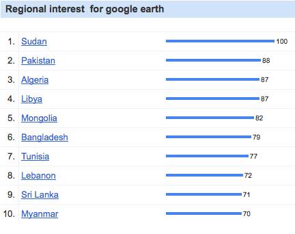
If you look at the other countries on the top-10 list, it’s remarkable that all are developing countries, seven are predominantly muslim, and six are run by authoritarian regimes (Myanmar being another case where US laws prohibit the downloading of Google Earth). What’s heartening is that this list is pretty much the same as the one where widespread use of Google Earth would do the most public good.
Residents of countries where Google Earth is forbidden can of course take heart in the fact that the same imagery dataset is available via the web, without US-mandated restrictions, on Google Maps. And soon, very very soon, Google Earth will be in the browser for all — though it will be interesting to see if such a browser plugin is subject to the same export laws as the standalone version.
- FastSatfinder: This Google Earth browser plugin app lets you find the direction to a long list of geostationary satellites from any location on Earth (if it’s in your line of sight, duh). I can’t test it on my Mac yet, but no doubt it works in a similar fashion to the previously reviewed Dishpointer. FastSatfinder also comes as a $30 Windows standalone version, with extra features that I suspect are of use mainly to the dedicated hobbyist. (Via Boxier’s Weblog)
- Street View, post-disaster empathy tool: In the latest update to Street View, all of New Orleans is visible, and three years on from Katrina chunks of it are still looking miserable.
Are you empathising yet? Want to help? That’s the idea behind Street View in New Orleans, according to Louisana Lieutenant Governor Mitch Landrieu writing on the Official Google Blog.
If it works, why not take it to the extreme — I wonder what Street View of a Darfur refugee camp in Chad might do? (Via James Fee)
- Driving directions with the Google Earth API: Google Maps Mania flags a post on the Google Geo Developers Blog: “Simulating Driving Directions with the Earth API and Maps’ Directions API” (direct link to app) and makes a demo video.
One thought on “Links: Sea ice animation; Google Earth search trend; FastSatfinder”
Comments are closed.
Can you explain why this search yields a radically different top-ten list in regional interest?