HeyWhaysThat, the panorama generator for Google Maps and Earth I raved about two weeks ago, now does most of the rest of the world as well.
For example, here’s the view from the top of the Matterhorn, and here’s the view from Monte salvatore, near Lugano, from where you can see the Matterhorn, as confirmed by me last year and HeyWhatsThat today.
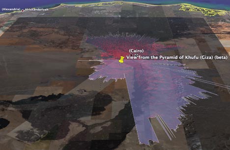
But there are even more esoteric uses of HeyWhatsThat. It’s forbidden to climb the Pyramids of Giza, but at least you can now create your own virtual panorama. Check it out in Google Earth to get an idea of just how breathtaking the view must be:
Below the fold, an email with more details, tips and information from HeyWhatsThat’s Michael Kosowsky.
HeyWhatsThat now covers the world (at least that part of the world between latitude 60 degrees north and 54 degrees south).
The system uses two kinds of data: the elevation of the earth’s surface and the names of summits. The elevation data for the rest of the world seems on a par with what we’ve been using for the US, so silhouettes and visibility cloaks (aka “viewsheds”) look pretty good. But the summit name coverage outside of the US is pretty uneven. In the handful of tests I’ve done, for example, the system hasn’t been able to find any peak names outside of Great Britain and Canada.
For this reason, requests outside of the US will come back “beta” stamped all over them, where “beta” means “if you can get us more data for free please get in touch.” (More on data can be found at the faq)
In addition to adding the non-US data, we’ve got newer versions of US data on the site and we’ve tweaked some of the computations, generally producing less ragged cloaks and panoramas. Feel free to re-run some of your old queries.
For expert users: in advance of actually implementing the feature the right way, we’re giving you a hack to overlay the summit name data on the map. Create a bookmark whose URL is
javascript:getnamesdata()
When you’re at our site and you click that bookmark, you’ll get a bunch of little blue plus signs representing the data we’ve got for the square degree of latitude and longitude containing the center of the map. Mouseover for names and elevations. Slide the map and click the bookmark again to see more summits.
Finally, since my last email, the site has received some wonderful reviews. I’ve listed the ones I know about here.
MK
Great news! I was disappointed of reading that it was only for the USA.