The fates of Google Earth and SimCity have been intertwined before. Back in August, we had news of gamers using Google Earth as a visual reference for the accurate recreation of real cities in SimCity 4. We also heard of a method to convert SketchUp models to SimCity models.
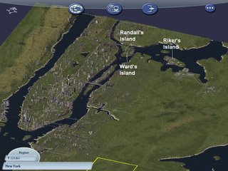 Fast forward a few months, to an interview in BitsBytesPixelsSprites with Elliot Hanson, who is recreating the entirety of New York City pixel by dimetric pixel in SimCity. The interview has some stunning images, but there’s even more on Elliot’s own blog, The New York City Journals. I especially like how some projects are seasonal or event-driven, animated by scripts built into the objects — for example, there is a Thanksgiving day parade, and a recreation of 9/11.
 Not surprisingly, Elliot is also playing with Google Earth, collecting models from 3DWarehouse of New York Buildings. All this leads to an obvious question: Might it not be possible to export SimCity content as a SketchUp model, ready for positioning in Google Earth? Pixel art in Google Earth would be quite a trip, and a layer in Google Earth with Elliot’s work in it would definitely give it wider exposure. We know it’s possible to export 3D content from Second Life and World of WarCraft, as shown by Eyebeam’s OpenGL Extractor, so why not with SimCity?
And thinking further ahead, if/when Google Mars comes out, the opportunities for populating that planet with SketchUp models should make for some excellent collaborative creativity. Anybody up for a chalet with view overhanging the edge of Valles Marineris? It would make for an interesting mirror world/virtual world hybrid, especially as the Mars imagery won’t come with pre-existing infrastructure on it. Hmm, Martian Chronicles, the MMORPG. Isn’t it great we live at a time when such ideas aren’t outlandish?