- Andrew Hudson-Smith has a really cool preview of his upcoming Panorama Viewer for Google Earth (complete with YouTube video). This is a must-visit link. I can’t help but wonder if this is the sort of thing that’s in store for the Google-Pennsylvania Civil War project announced last week.
- Valery Hronusov demos an undocumented feature of Google Spreadsheets. Just as EditGrid does, Google Spreadsheets now also lets you access specific cells or a range of cells via a URL and have it display as text. The secret is to append “&output=txt&range=a1:b3” to the URL of a spreadsheet, where the range of cells to display is A1 to B3. Just put “&range=a1” if you want to display just one cell — which is precisely what Valery did to produce KML from a Google Spreadsheet.
How? Just as with his early experiments using EditGrid, Valery put the shell of a KML template in cell A1, and then used the CONCATENATE function all over the place to build valid KML markup from cell-based data.
Here is his sample spreadsheet.
Here is the contents of cell A1 as a textfile.
Here is that output stuck into Google Maps (as one does).
Google Spreadsheet still doesn’t have EditGrid’s more advanced features: You can’t get your spreadsheet as XML, nor can you apply an XSLT stylesheet to it to convert it to KML systematically (like this). But, says Valery, the one main advantage of Google Spreadsheet is: “It is fast!”
- On a Related matter — Valery Hronusov was at the AGU in San Francisco last week, and he has just put his photos from the event up on Flickr. Here he is with Alan Glennon (of Geography 2.0).
- Looks like there is a Virtual Globes Symposium in Massachussets on January 19. NERCOMP: Virtual Globes: GIS 2.0 (Via GIS@Vassar)
SpaceNavigator in NyTeknik top list, gets competition
How is the 3D controller market looking these days?
Here in Sweden, just a week after 3DConnexion’s SpaceNavigator got a glowing review in the Swedish Geek bible, NyTeknik, it makes it to position number 5 in that publication’s list of the year’s top 12 products, out today.
That’s quite a feat — number 2 on list is the pistol-grip battery-operated torque meter used by Sweden’s first astronaut, Christer Fuglesang, during the current Space Shuttle mission. SketchUp also makes it to the list, no doubt because the reviewer finally started playing with it using the SpaceNavigator. And given that my MacBook Pro is also on the list, I’m feeling rather special right now. (No, I’m not responsible for the list:-)
Also today, news of competition for the SpaceNavigator. Sandio has a press release out announcing the VisonTek XG6, which is primarily aimed at gamers. It sounds promising — apparently it works with Google Earth out of the box as well:
With the new VisionTek XG6 mouse, PC users are now able to move along and rotate about x, y, and z-axis, action that requires users to work with multiple keys on the keyboard or an on-screen navigation bar when using a traditional mouse. The VisionTek XG6 mouse allows PC users to move freely on Google Earth, Google SketchUp, and all PC games. VisionTek XG6 also employs high precision laser sensors and offers users greater flexibility through multiple dpi: 400, 800, 1600 and 2000.
 The product website shows you what the packaging will look like, and there is a graphic that shows (sort of) how to the mouse is supposed to let you navigate with six degrees of freedom. It doesn’t seem to be on sale yet, and there is no word on price.
I am of course perfectly willing to review a VisionTek XG6 should it show up on my doorstep, but until then, they’ll have to pry my SpaceNavigator out of my cold dead hand.
GeoServer 1.4.0: The view from Google Earth
Chris Holmes, GeoServer’s lead developer, writes in with details about GeoServer 1.4.0, now fully released:
From the perspective of Google Earth, the improvements we’ve had since 1.3.x with KML are a few fixes for better styling, and better naming of files when one downloads KML from GeoServer.
But although there’s not a ton that’s Google Earth specific, the rest of the push for 1.4.0 was to migrate to Spring for the core. This is the first step in making it easier for programmers to build interesting services on top of the core functionality (ability to read from Shapefiles, PostGIS, Oracle Spatal, ArcSDE, ect. in to a common programming model, and output that to different formats), any of which will be available as streaming KML/KMZ.
The next release (1.5.x) will add some very good raster support, and we’re going to be looking in to doing super overlays from rasters with no additional configuration (including caching them for great performance). And eventually vectors as well, but they are a bit more challenging if you’re doing anything more interesting than just turning all the vectors in to a raster.
I love it when a post writes itself.
Virtual Italia 3D
How I love competition. Windows Live Spaces announces that Virtual Earth now has all of Italy in high resolution, beating Google to the punch. No doubt, this is a direct result of the deal with Norway’s Blom (blogged here) a company that has quite an inventory of Italy imagery (and which provided the bird’s eye views over several Italians cities released last week.)
Something caught my eye: The third-party imagery used by Microsoft for Virtual Earth does not come with copyright statements from contributing companies — all it says is “© 2006 Microsoft Corporation”. I wonder if this costs a lot more? Remember, too that the Blom agreement allowed for its imagery to be used at work — there is no constraint on using Microsoft’s Virtual Earth 3D at the office. I’m guessing that Microsoft is paying handsomely for all this “smoothness”.
With Google’s purchase of Endoxon yesterday, it really seems like the battle for Europe is heating up between these two giants.
Google: Sweden now part of Norway (Shock!)
Just about every online publication you can find in Norway right now, and a Swedish paper to boot, is reporting on how if you type “Norway” into Google Earth, it directs you to a spot in the middle of Sweden. Considering that Norway was a part of Sweden until 1905, this is getting a lot of play — the official angle is that according to Google, Sweden now belongs to Norway. (It’s funny in an understated Scandinavian sort of way — you really had to be here.) In some cases, photo editors have conveniently helped along the story by turning off the country names layer before taking the screenshot, as on that layer the names are marked correctly, and that would just ruin the fun.

But why might a search for Norway in Google Earth end up with a placemark in Sweden? My first guess was that Google somehow finds the center of gravity of a country, and in the case of Norway, the country is so oddly shaped that it could just conceivably fall outside the borders of the country itself. But just from looking at Norway, there is no way that the center of gravity would be that far into Sweden.
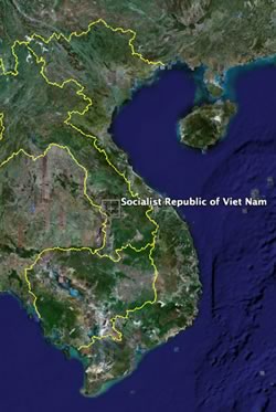 Instead, I think I’ve figured it out. What Google returns is the coordinate point whose longitude is halfway between the easternmost and westernmost point of a country, and whose latitude is halfway between the northernmost and southernmost point. In the case of Norway, that’s far into Sweden. In the case of Sweden, that’s just into the Baltic Sea. There are in fact few countries where this point does not actually fall within its borders. I had to do a bit of a search, but finally found Croatia, Israel, Laos and Vietnam. If you find others, do let me know.
This is obviously a completely arbitrary piece of geographical trivia, as we’d merely have to agree on using a different reference frame for our coordinates and we’d get different answers. Even so, I reckon Croatia would have a hard time finding any coordinate system that allows this point to fall within its borders. Just nobody tell the Bosnians they “belong” to Croatia, or it’ll be 1992 all over again.
Swiss paper: Details about Endoxon purchase
Local Swiss paper Le Temps has some further interesting details on Google’s acquisition of Endoxon. If you speak French, read it here, else the highlights are below, translated:
The contract was signed last friday, the price of the agreement was not disclosed, and it’s the first Swiss company bought by Google.
Endoxon was founded 18 years ago by two bothers, Stefan and Bruno Muff. Until last friday, it employed 80 people, with offices in Switzerland, India and St. Petersburg. Its Indian subsidiary assembles satellite images of different countries (Switzerland, Germany, Austria, Japan, Dubai…) and adds layers of points of interest.
“We are the best,” assures Samuel Widmann, Endoxon’s [ex-]CEO. “Nobody in the world assembles as much information as we do on maps.”
In 2006, Endoxon will have revenues of 10 million Swiss francs (USD$ 8 million).
Google is buying Endoxon’s database of POIs, its international subsidiaries that process and create the digital maps, as well as a mobile division, whose products are not yet on the market.
The other activities of Endoxon, (classic cartography, geomarketing and the “Trinity” tool that enhances MSFT Outlook) will be regrouped into a new company called Mappuls.
Around 50 of Endoxon’s 80 employees, among them Samuel Widmann et Stefan Muff, will join Google’s Swiss offices in Zurich. [It’s not clear from the article if those 50 include the subsidiaries.]
“It’s excellent news for us… and also for Google!” says Stefan Muff. “We have Swiss quality standards, and our solution will be able to be applied globally.”
Google’s Kay Oberbeck, Google spokesperson for Northern Europe, is quoted as saying: “We are first going to extend their applications to other countries on the old continent [i.e. Europe], and it’s not impossible that we’ll go beyond that.”
That’s what the article said. I find the India connection most interesting. Map processing can be repetitive, and cost effectiveness in this field can mean far more processing for the buck.
Endoxon bloggers now Googlers
Looks like there are at least two newly minted Google employees who only yesterday were blogging as Endoxon employees: Bernhard Seefeld and Gregor J. Rothfuss. In to my newsreader they go.