- EarthBooker launches a service whereby you yourself can automatically add your hotel to their database and position it using Google Earth. It leads you through the whole process, including setting up an account, and then at the very last moment, after you’ve done all the work, it informs you that you’ll have to pay them if you want your hotel to be visible with their service: $5 for a week, $15 for a month, etc… The press release doesn’t mention that it costs to be listed, nor does the website. In fact, consumers using the service have no idea that they are only seeing hotels that have paid to be there. They may assume, as I initially did, that the list is comprehensive. There’s no way to avoid concluding that this constitutes two counts of misleading advertising. (Mac users are spared the bother, as it doesn’t work with the Mac version of Google Earth.)
- Le Monde comes with its own multimedia Google Earth sightseeing guide, featuring some of the more stunning aerial views. You’d think the editors would add a link to the actual image in Google Earth, but no… It’s the equivalent of listing the titles of your favorite sites, but then not showing their URLs.
- This post of Google Earth Community pointing to a spot in a remote part of China where there is a giant miniature landscape of another spot on the disputed Chinese-Indian border (if that makes sense) has received plenty of web attention today. Even The Age picked up on it. It’s certainly one of the weirder views available in Google Earth.
All posts by Stefan Geens
Israel-Lebanon conflict, now in KML
Following up from last night’s post, where I lamented the lack of geospatial documentation of the Israel-Lebanon conflict — I’m glad I didn’t start on a KML file because this morning’s trawl through the newsfeeds brought up an exhaustive and wholly impressive KMZ file documenting with pinpoint accuracy (where possible) the events of the past week on both sides of the border. For example:
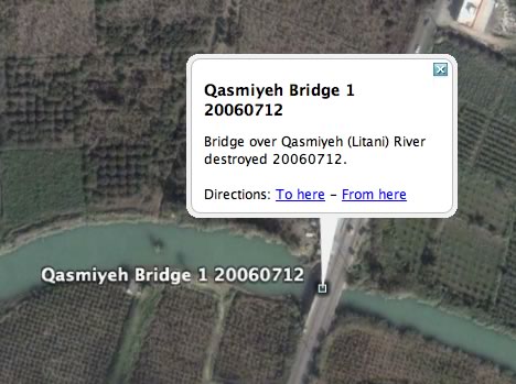
Here is the file’s launch page. Leave it to the locals to come up with the most immersive way into this war.
How would I improve it? I’d turn it into a network link, so that it gets updated automatically as content is added; I’d put individual day’s events in folders, so that a timeline can be simulated; and I’d use different icons for different kinds of events — different colors for different actors, and different symbols for rocket attacks, plane attacks, incursions, abductions, etc… But all that takes time, of course, and preferably a spot outside of a warzone.
(Finally, a KML feature request: It would be nice to be able to categorize KML objects, so that you could filter for, say, just Hezbollah rocket attacks, or just Israeli bombardments on July 18.)
(Via NL-Outsidethebox)
Mad dogs & Englishmen & I
Bloody hell it’s hot here in Cambridge. Sure, I’ve been in heat like this before, in New York City and Spain and the Sinai and the Australian outback, but those places expect the heat, and come air conditioned or wrapped in thick walls and shuttered windows, or are sensibly empty of people.
In the East Village at the height of summer, even the skankiest bars have the air conditioning humming, and in my more bohemian days it was definitely cheaper to pay for coolness in beers at bars than in electrical bills (and beers) at home in a tenement walkup. English pubs — even those with wireless access — have yet to discover that cold interiors attract customers.
All this by way of explaining that it is too hot to blog Google Earth tonight. I was all ready to have a go at documenting the Lebanon-Israel conflict in KML (why are no news organizations taking the lead? This is the first war of the geobrowser era) but, well, I’m just in a whiny mood instead. I might have a go during the weekend.
In the meantime, enjoy this ditty by Noel Coward (.wav). Lyrics below the fold.
Short news: Anonymize Google Earth; Giza2Orion?
- Uwe Hermann notices that you could anonymize your surfing with Google Earth using Tor, should you be so inclined…
- Are the pyramids at Giza lined up in the same pattern as the stars of the belt of Orion? Over on Flickr, “933K” superimposes a picture he took of Orion’s belt onto Google Earth to check for himself…
- New Google Earth Blog hits the radar screen: Google’s Earth.
- Ooh, Ah. BLDG|BLOG finds a very cool NASA Earth Observatory 3D visualization of a storm front over the Pacific. The animation is worth watching — I wonder how long it will take before that plays live in a geobrowser near you.
Gombe Chimp redux
I just now revisited the Gombe Chimpanzee Blog, which posts its content exclusively to Google Earth, only to find that all of Gombe National Park on the shore of Lake Tanganyika in western Tanzania is now in glorious high resolution. This must have happened in the data update from a month ago. It makes visiting this blog all the more worthwile.
But the enhanced resolution also drives home that Gombe Chimpanzee Blog could really use a makeover. It already has the content, which is the hardest part. Why not deliver the posts via a network link, so that we can subscribe? And why not add to this network link some static overlays that identify the main villages and most frequented spaces, so that mentions of them in a post aren’t as cryptic? With the improved resolution, all this now really matters. With a few hours of invested time, this blog could really become the alpha male of georeferenced blogging.
Social spying: North Korea’s turn
Open Source posts about the budding social spying phenomenom — in this case, it’s North Korean military sites being identified on Google Earth Community.
The quote by the retired US veteran isn’t accurate, however. No country has successfully requested or coerced Google to censor or remove data, Google has confirmed. Governments can and do coerce their satellite imaging companies to censor data, and indeed US satellite companies are obliged by law to ensure they do not sell imagery of Israel that is of a higher resolution than non-American vendors. But Google doesn’t have to buy from them. (Via Boing Boing).
Directional icons in Google Earth
After last week’s attempt to create directional vector graphics for Google Earth, a commenter left a note saying that you can in fact control the heading of an icon, which would solve most of the problems posed. I just had a go playing with the <heading> tag under <iconstyle>, and it does indeed work, sort of.
My aim just now was to recreate in Google Earth the weather symbols that meteorologists often use, such as these (from which I stole the graphics). Again, I didn’t intend to do a good job; I wanted to see if it’s possible.
These weather symbols have two main components — wind speed/direction and percentage cloud cover. Only the wind speed/direction has a directional component to it, so I decided to split the symbol into two overlaid icons, with only the wind component being fixed by a <heading> tag. (This has the added advantage of needing to create far fewer symbols, because you can mix and match different components.)
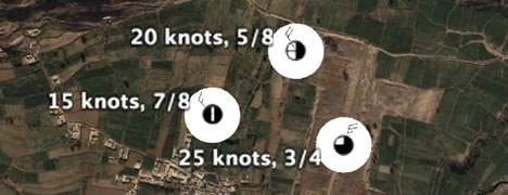
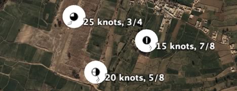
The result is that while the cloud cover icon is always “right side up” like conventional icons, the wind icon will point in the direction dictated by the <heading> tag — though only accurately if you look at these icons from directly above. View them at an angle, and the direction is only accurate every 90 degrees as you rotate.
(Note: I used the ruins of Taxila — an ancient Buddhist seat of learning and a town populated by Alexander the Great — as the backdrop for the test icons. Download the KMZ file for an added “feature” I discovered while veering off the beaten path there, oh, 12 years ago. No guarantee it’s still there, though the stuff did grow wild everywhere.)