Iran missile base post-explosion imagery, now hi-res in Google Earth

On November 12, a powerful explosion ripped through an Iranian missile base on the outskirts of the town of Bīdgeneh, 40 km west of Tehran. As the Guardian reported soon after, among the dead at the base was the architect of Iran’s missile program, Major General Hassan Moghaddam. There has been heavy media speculation the explosion might have been the result of a covert operation by Israel’s Mossad.

Post-explosion satellite imagery has now become available that shows the extent of the destruction. Commissioned by the Institute for Science and International Security (ISIS), the imagery was taken on November 22, 2011. ISIS Senior Research Analyst Paul Brannan has published the annotated image along with the most recent available imagery from before the explosion, taken September 9, 2011. He adds:

ISIS learned that the blast occurred as Iran had achieved a major milestone in the development of a new missile. Iran was apparently performing a volatile procedure involving a missile engine at the site when the blast occurred.

You can’t tell from the imagery if sabotage caused the explosion, but you can tell the damage was extensive, wiping out most structures at the base. The NYT elicits more commentary from Paul Brannan in an interview.

Because ISIS’s web post and accompanying PDF used lower-resolution versions of the Nov 22 image, I asked ISIS for the original high-resolution image, to overlay on Google Earth. The September 9 imagery is already in Google Earth’s base layer, so it was just a matter of overlaying the one new image. Here is the resulting KMZ file, containing the high-resolution original, ready to open in Google Earth.
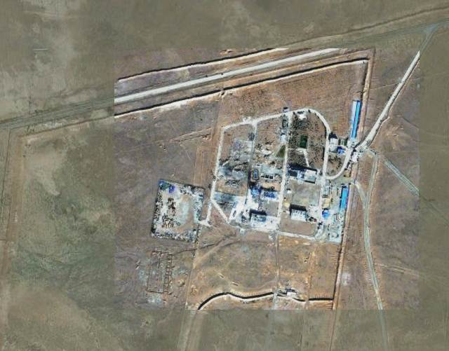
In Google Earth 6 and above, remember to click on the opacity button in the sidebar and then play with the opacity slider to switch between the before- and after- imagery. For reference, the sports court at the base is 30×15 meters, about the size of a basketball court.

P.S. On November 28, an new explosion ripped through what appears to be a uranium conversion plant near Isfahan, rattling windows in the city. Speculation is mounting (some based on intelligence sources) that Iran’s nuclear and missile programs are being systematically sabotaged or attacked. In 2010, the Stuxnet worm caused heavy damage to the uranium enrichment facility at Natanz.

In Slovenia, photography gets regulatory scrutiny

Over at Dliberation, I’ve reported on a story with a geolocation twist likely of interest to Ogle Earth readers:

In an unfortunate bout of regulatory innovation in Slovenia, the information commissioner there has decided that panoramic photography benefits from less legal protection than conventional photography because she reckons panoramas make it is easy to tell where the photograph was taken, and when, thus compromising the data rights of the people in the shot. She argues this, apparently unaware that all modern digital photography comes with EXIF time stamps which sites such as Flickr will automatically share, while many smart phone camera apps will attach their location to photos published to Twitter or Facebook. Photographs of landmarks also situate individuals at a certain place at a certain time. The commissioner may have unwittingly condemned all such photography to Street-Viewesque blurring requirements — at least if she is consistent in her logic.

I “blame” Google for this:

[This is] a case study of how Google, by voluntarily implementing facial blurring in its relatively new but hugely popular Street View automated 360-degree panoramas, created norms in the minds of regulators that they are now eager to set in stone legally.

Because Street View is so popular, it is quite possibly the only kind of immersive panorama that most people have seen. I believe this has altered popular expectations regarding the blurring of individual faces, which led to the commissioner decreeing that all panoramas not depicting a news-worthy event need to be blurred. Ironically, Google Street View isn’t even available in Slovenia:

That’s because Slovenia said it would require Google to keep the raw Street View images in Slovenia until they were blurred — no unblurred images were allowed to leave the country. Because the blurring makes use of Google’s servers, none of which are in Slovenia, Google respectfully declined to add Slovenia to its Street View program.

Read the whole article over at Dliberation.org.

Announcing Dliberation.org

In case you wonder what else I get up to, in terms of my interests: I’ve started Dliberation.org, a blog about the global social and political impact of digital networks. What Ogle Earth is to digital atlases, Dliberation is to digital networks — so yes, it is a lot less niched, but in line with how my interests have developed these past few years. Ogle Earth continues to be the place where I report on how Google Earth affects science and society; for a broader look at Internet regulation, censorship, surveillance, activism and cybercrime, visit Dliberation.org. Here’s the inaugural post, about a new research center for the Internet and Society, situated in Berlin and funded by Google. I hope you enjoy reading it as much as I will enjoy writing it.