UN, Google, Cisco to launch Millenium Development Goals Monitor

Remember that neogeo job advertised by the UNDP back in September for the Millennium Development Goals Monitor? Well, it’s ready to be launched. Here’s the media advisory, which begins thus:

UN, Google, Cisco to unveil online resource in the fight against global poverty

What: Press Briefing by UN Secretary-General Ban Ki-moon, UNDP Administrator Kemal Derviş, Google Chief Technologist for Google Earth and Maps Michael T. Jones, and Cisco Senior Vice President Carlos Dominguez.

When: Thursday, November 1 from 12-12:30pm

Where: Room 226, UN Secretariat

MDG Monitor is a web application that tracks real-time progress toward the Millennium Development Goals in a number of categories in nearly every country in the world. The new online resource is a one-stop-shop for MDG information and will serve as an educational and advocacy platform featuring the most current data from multiple sources in development bellwethers like public health, education and women’s empowerment.

Can’t wait to see what the MDG monitor is about? Read the job description that was advertised.

Neoconservatism vs neogeography, Syria edition

Neocon Express is quick to take credit for having found the alleged Syrian reactor on Google Earth soon after if was bombed by Israeli jets on September 6:

Not long after hearing about the Israeli raid on September 6th, I did a quick search on Google Earth, and easily found the suspected facility that was bombed (although I wasn’t sure that that was the exact facility until the images became public).

That’s quite a remarkable achievement, considering that until October 23, the imagery of the location in Google Earth looked like this:

viewgm.jpg

Only with the Oct 23 data update did the building become visible in the Spot Image 2.5m imagery that was added to Google Earth on that day. ISIS released its commissioned high resolution DigitalGlobe images on October 24. If you’re quick, you can still see the pre-Oct 23 imagery in Google Maps.

Then again, the neocons are so deep in denial about their failed approach to the Middle East, what difference does one more lie make?

And isn’t forensic neogeography fun?:-)

Meanwhile, in other Syria-related news:

  • The New York Times carries an article showing a GeoEye image taken from September 16, 2003, showing that the rectangular structure existed then.
  • ISIS releases another PDF, this time highlighting the fact that the Oct 24 imagery shows part of the mountain removed — the thesis being that this dirt was used to bury the building’s foundations.

Yes, we have no nuclear reactor

Via the BBC and also the NYT this morning comes word that Institute for Science and International Security (ISIS) have released some more imagery of the suspected attack site in Syria on September 6, this time taken last Wednesday, October 24 — just two days ago.

That square building? It’s completely gone! All that’s left is scrape marks and the odd bulldozer:

syriaafter.jpg

Compare to the imagery before taken before the attack, on September 6:

syriabefore.jpg

That just about confirms that this is indeed the spot. ISIS adds:

Dismantling and removing the building at such a rapid pace dramatically complicates any inspection of the facilities and suggests that Syria may be trying to hide what was there.

There’s more good analysis in the PDF.

I’ve turned both images in the PDF into high-resolution KML overlays. Get the KML file here. The August 10 layer is turned off by default, but turn it on and play with the opacity sliders to compare before and after imagery, as well as with the Spot Image base layer in Google Earth. Images don’t match up exactly because they were taken at oblique angles and are of hilly terrain.

syriainge.jpg

Links: PhotoOverlay tool, Leopard reads GPS, Free Canada roads

This is what happens when things get busy around here: Stuff piles up. Time to dive into this week’s links…

  • PhotoOverlay tool: Digital Urban announces Google Earth PhotoOverlay, a free Windows app that automates the creation of the KML you need to publish your panoramas to Google Earth using the new PhotoOverlay tag in KML 2.2, supported in Google Earth 4.2.
  • NeoGeo Co-opetition: Oy, what’s going on here? First All Points Blog reports that Google Earth’s Brian McClendon and Microsoft’s Erik Jorgensen get all touchy-feely about KML, and now we hear on the Google Enterprise Blog that Google and ESRI are collaborating to better serve government employees. Let’s hope everyone’s faking:-)
  • Leopard does GPS metadata: I’m having Amazon Fedex Mac OS X 10.5 to a friend who will put it on the first plane to Cairo, as it would be intolerable to run an outdated operating system, and Amazon isn’t shipping Leopard to Egypt. One of the 300 new features of Leopard:

    GPS Metadata Support
    Get real information from your photos. If your image has embedded GPS metadata, Preview will show you exactly where that perfect photo was taken. Open the Image inspector and select GPS. Preview pinpoints the location where you took the photo on a world map. From there you can even open the GPS location in Google Maps.

  • Neogeoblogger minimeetup: Last weekend I had a pitstop in Antwerp to see the family. I also met up with Belgeoblog‘s Pascal, who has the Belgian market in Google Earth cornered. Here he is on Flickr.
  • AutoCAD to Google Earth: “An updated version of the Google Earth Extension for AutoCAD is now available on Autodesk Labs.”
  • Canada roads, for free: Peter Rukavina notes that Canada’s National Road Network is now available as free download as KML, ESRI Shapefile, and GML. Peter adds:

    For anyone interested in GIS, map-hacking and similar pursuits, the NRN is an amazing dataset. That it’s made freely available for any use is a dramatic departure from usual practice with government data in Canada, where we usually have to pay for data that is, by all rights, already “ours.”

    UK Ordnance Survey, are you listening? Take some advice from the colonies.

  • Dutch blog: Another Dutch-language Google Earth blog hits my radar screen for the first time, GoogledEarth-blog.nl. (I keep on reading it as Google Dearth, though:-)
  • Global Mapper to KML: Global Mapper is “a [$300 Windows] program that has an amazing ability to display, convert, edit and print the most popular image, elevation and vector datasets.” Now it also exports to KML.
  • Morocco censorship redux: More anecdotal evidence that Morocco continues to ban Google Earth, and a lot else besides. Glad I visited before the internet was invented:-)
  • Keyhole history:Frank Taylor links to an hour-long video of a presentation by Google Earth President John Hanke about the early days of Keyhole, and how they became Google Earth. Avi Bar-Zeev adds some color.
  • Unstructured data to Google Earth: Interesting press release:

    NetOwl, an advanced multilingual text mining platform developed by SRA, is now fully integrated with the Google Earth service. This new capability enables knowledge workers to rapidly analyze, geotag, and geoparse large amounts of unstructured data from a diverse number of sources and languages, and it georeferences the results in new and innovative ways through Google Earth. It also provides the ability to fuse structured and unstructured data and imagery, and to tailor specific requirements to their individual needs…

    Sounds like what Google did with their book layer in Google Earth.

  • Cool Virtual Earth feature: Here’s a feature I didn’t really get until Virtual Earth Blog explained it in detail (it’s item number 6): You can subscribe to a KML file on the web, and if it is updated you get the news via a GeoRSS feed. Clever!
  • Virtual Earth inside ArcGIS: This is verging on the freaky: According to Virtual Earth Blog, soon Brian Flood’s Arc2Earth will have the “ability to embed VE/VE3D directly into ArcGIS as a custom view. Watch for this update in about a week according to Brain Flood, creator of Arc2Earth”. Brain flood indeed:-) Check out the screenshot.
  • KML to GPX: KMLToGPX Converter 2.0 is out, free, and available for Windows and Mac.
  • LoadMyTracks: The free LoadMyTracks utility for Mac gets an update to fix Leopard compatibility. This is my utility of choice for getting GPX files to and from GPS receivers and turning them into KML.
  • Free KML tools: Free Geography Tools flags two new online KML tools by Zonum Solutions: KML-GRID (which draws a grid to your parameters as KML) and KML-Area & Length (which takes your KML polygons ad calculates areas, which Google Earth Free doesn’t do).
  • California fires: Google releases a master layer that includes all the imagery released so far. GeoCommons has also collected all its fire maps into one place.
  • Comet! And finally, thanks to Frank at Google Earth Blog for alerting me to the brightening of Comet 17P/Holmes, and where to find it.

Guardian: Gazan rocket launches planned with Google Earth

The Guardian comes out with the archetypal “terrorists are using Google Earth” piece this morning:

Palestinian militants are using Google Earth to help plan their attacks on the Israeli military and other targets, the Guardian has learned.

Members of the al-Aqsa Martyrs Brigade, a group aligned with the Fatah political party, say they use the popular internet mapping tool to help determine their targets for rocket strikes.

“We obtain the details from Google Earth and check them against our maps of the city centre and sensitive areas,” Khaled Jaabari, the group’s commander in Gaza who is known as Abu Walid, told the Guardian.

And there’s the video to prove it (2:30m in):

awbuw.jpg

It’s not the sort of endorsement one wishes for. But Abu Walid is trying to boast about his militancy, as his Al Aqsa Martyrs Brigade is now trying to outdo Hamas in the toughness stakes in order to win over the Gazan population. Google Earth is mentioned because it is a new tool — it is the best way yet to find the local supermarket, regardless of who you are. The Volkswagen bus used to transport the rocket doesn’t rate a mention by Abu Walid, but that’s because both we and he are used to terrorists having cars.

abuvw.jpg

Ditto for the maps they use, the cellphones, the HP computer on which Abu Walid runs Google Earth, and their internet connection. Google Earth (and Virtual Earth and Yahoo Maps) are the new universal for placing yourself in the world and navigating it. Denying ourselves that tool and all the good that comes from it because we think it spites terrorists would be a pity. Google Earth’s imagery is definitely cheaper and more convenient than what Abu Walid had access to before, but taking it away from him and us would diminish his effectiveness by very little, whereas the cumulative cost to the rest of us would be far greater.

[Previous “terrorists use Google Earth” stories: Terrorists use Google Earth in Algeria, militants use Google Earth in Iraq, militants use Google Earth in Yemen.]

October 23 Imagery update for Google Earth

This blog needs a big catch-up post, but to whet the appetite, Google Lat-Long Blog just listed the precise contents of the unexpected imagery update that happened on Oct 23. It took me until after posting the story on Syria earlier today to realize what wonderful timing this update had, as Tunisia, Syria, the UAE, Jordan, Lebanon, and Israel now all benefit from 2.5m-per-pixel Spot Image base imagery.

What else of note? Personal favorites are new high-resolution imagery for the entire State of Oregon, and also for the Swedish city of Umeå, where the data is credited to the city council. Smart move Umeå! Stockholm’s hi-res imagery is updated, as is Windhoek’s, Ulan-Bator’s, and that of a whole slew of other exotic-sounding cities. The whole list is copied below the fold, for archiving.

Continue reading October 23 Imagery update for Google Earth

Sept 6 raid in Syria: New location clues emerge, with imagery

Where in Syria did those Israeli planes attack on September 6? Rumors have been swirling for weeks, though without any positive identification. That didn’t stop us from playing the guessing game on September 23, identifying a possible site based on “information” leaked to the press.

It now looks likely I guessed wrong. First, on October 19, ABC News had a “senior US official” describe the location thus:

The official said the suspected nuclear facility was approximately 100 miles from the Iraqi border, deep in the desert along the Euphrates River. It was a place, the official said, “where no one would ever go unless you had a reason to go there.” […] The official described the pictures as showing a big cylindrical structure, with very thick walls all well-reinforced. The photos show rebar hanging out of the cement used to reinforce the structure, which was still under construction.

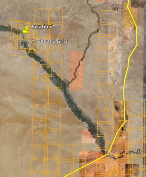
If you look at the map of Syria, there is just one spot where the desert touches the Euphrates; it’s about 80 miles from the closest border, or 100 miles from the border if you follow the Euphrates. It is also the location of some extensive on-demand DigitalGlobe imaging from July 2007, as shown by the orange squares below. Somebody wanted to get a better view of that area.

syriawide.jpg

Finally, just today, the Washington Post reports what it believes to be the precise location, quoting a former UN weapons inspector working for the Institute for Science and International Security (ISIS), which this blog has covered in the past when they mapped Iran’s nuclear weapons programme. WaPo names the exact location, but does not provide imagery itself:

Photographs of the site taken before the secret Sept. 6 airstrike depict an isolated compound that includes a tall, boxy structure similar to the type of building used to house a gas-graphite reactor. […] The facility is located seven miles north of the desert village of At Tibnah, in the Dayr az Zawr region…

As for how reliable this location is:

U.S. and international experts and officials familiar with the site, who were shown the photographs yesterday, said there was a strong and credible possibility that they depict the remote compound that was attacked. Israeli officials and the White House declined to comment.

With those caveats out of the way, where would this location be? ISIS’s website doesn’t have any images up as of this writing (it likely commissioned those DigitalGlobe images taken in July 2007 [Update: See ISIS’s imagery at the end of this post]), so let’s go looking at what Google Earth has to offer…

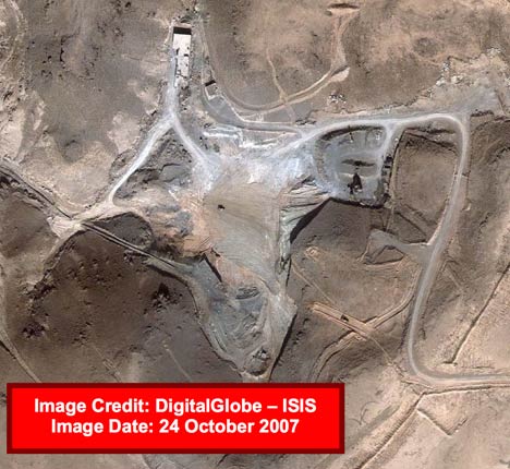
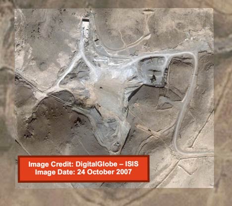
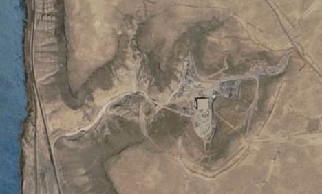
On closer inspection, it turns out all of Syria got much improved Spot Image image coverage in Google Earth since last time I looked a few weeks ago. [Update: This imagery was added yesterday.] And sure enough, if you head 7 miles due north from Ab Tibnah (found via a simple search in Google Earth), you land in the only area where the desert reaches the banks of the Euphrates. And there, on the eastern bank, is an unmistakable candidate nuclear reactor building, 45m x 45m in size, apparently still under construction.

location-ge.jpg

viewge.jpg

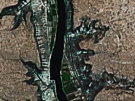
This new Spot Image imagery is not yet in Google Maps, so you can see the difference with what Google Earth showed just a few weeks ago, when we first went hunting for the location soon after the September 6 air raid. Here’s the view in Google Maps still today:

viewgm.jpg

Isn’t the march of technology a great thing?:-)

(I do wish we’d get a more complete accounting of what imagery is updated and when, though. Google’s Geographical treasure hunts are all good and well, but don’t substitute for a sober list of updated data.)

What incongruities are left? The ABC article mentions a cylindrical object, whereas the WaPo article talks about a tall boxy structure. Possibly, this is because the Spot Image images are a bit older. Where did my own previous guess go wrong? Dayr az Zawr is not just a town, but also a large administrative region. I assumed the mentions were of the town and calculated from there. That said, the initial leads that were reported in the Times of London turned out to be completely wrong. That’s what you get when you have spies as sources…:-)

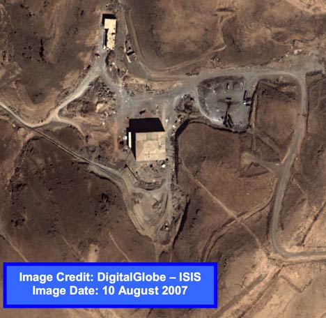
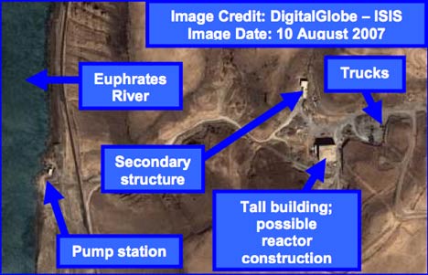
[Update 13:41 UTC: ISIS’s website now has the PDF report with the DigitalGlobe imagery, taken on Aug 10, 2007. Here it is:

isisdg.jpg

]