How geosavvy is Mac OS X Leopard?

Are you wondering what the photo georeferencing “feature” in Mac OS X 10.5 Leopard is like? Find a photo that has latitude and longitude already encoded in its EXIF metadata. Open it with the Preview Application, turn on the inspector, and voila, under the “More Info” tab you get the metadata above a small world map:

xfds.jpg

You can’t edit the GPS data, and the built-in map is about as rudimentary as you can get, but the Locate button takes you directly to the view in Google Maps in your web browser. That’s a smart bit of outsourcing, but it’s not as if the third-party photo georeferencing tools currently running on the Mac are in any danger of being outpaced by the operating system. And it’s also a bit curious that neither iPhoto nor Aperture have a built-in mapping solution in a time when photogeoreferencing has gone mainstream. HoudahGeo, GPS Photo Linker, Geotagger, PhotoInfo and LoadMyTracks have nothing to worry about.

Links: Extra-solar planets, OpenSocial multi-user Google Earth, World Bank goes neogeo

NYT: Google Earth to run on Google’s mobile platform!

When the Apple iPhone came out, we were told it ran on a variant of OS X. It was only natural to speculate whether it might not run Google Earth. Now Google has released the specs for Android, its mobile platform, and we are told it will run on a variant of Linux. Google Earth also runs on Linux, so do we need to start speculating whether Google Earth will run on Google-platform mobiles?

No need! The guy behind the platform, Andy Rubin, has just shown the New York Times a version of Google Earth running on a mobile device:

A brief demonstration of the Google software recently suggests that phones made using the technology will have features and design similar to the Apple iPhone. Mr. Rubin demonstrated a hand-held touch-screen device that gave an immersive view of Google Earth, the company’s three-dimensional visualization software.

Mr. Rubin, who is 44 years old and is a veteran Silicon Valley designer, said the software system that Google has designed is based on the Linux operating system and Sun Microsystems’ Java language. It is designed so programmers can easily build applications that connect to independent Web services.

As an example, Mr. Rubin said the company’s StreetView feature of Google Maps could easily be coupled — mashed up, in technology speak — with another service listing the current geographical location of friends.

That’s awesome! Okay, some caveats: “hand-held touch-screen device” could be something quite large, more like a car satnav device, in which case it wouldn’t be that special, as we’ve seen such prototypes before. And I wouldn’t put it past a reporter to confuse Google Maps for Google Earth (though John Markoff is tech-savvy).

Oh, and social APIs released last week, collectively called OpenSocial, are GeoRSS-savvy, discovers The Spatial Miscellany. Here’s the direct link to the Google Code reference, via Jason Birch. (Thanks Avi for the heads-up.)

Links: Brainloop; Burmese junta’s perks; Infrared sky

  • Future UI: Ah, more future-UI video candy. Check out Brainloop, which lets you control Google Earth with your… brain. Is this a good moment to point out that CIC Earth in Snow Crash was controlled by the brain? Brainloop’s controls aren’t continuous (yet): You use your mind to select discrete menu options, like zoom in, pan left, etc… Still, it makes for quite a performance:

    (Thanks, Jonathan!)

  • Where the generals live in Burma: Wow. (I can’t verify this, but it looks authentic.)
  • Infrared Astronomy: Orbiting Frog builds a query for NASA’s SkyView data (containing views of the sky at various wavelengths, not just visible light) and presents it as a KML network link for Google Sky. Zoom in to a part of the sky, wait a while, and up comes the view at 100 microns, taken from the Infrared Astronomical Satellite (IRAS). He’ll make more of them if you ask nicely:-)
  • Ranking patent: How does Google decide which items to show you on Google Earth when showing all of them would lead to visual overload? Well, it has a method, and the method has now been filed with the US patent office. Quote:

    The system may permit, for example, bounding box queries in lat/lng space (generated by a graphical interface such as Google Earth or Google Maps), and may also prevent showing too many items, such as when a user is viewing a very large geography (such as an entire country). The system may also permit for the ranking of items so as to show them in a preferred order.

    Google Earth’s been doing this sort of ranking for as long as I’ve used the application, which is why it was surprising to see others come out with patents for such methods. Back in 2005, someone in the Netherlands patented “altitude ranking”, though it was deemed trivial and not original by those in the know.

    Might the same be said for Google’s patent? I don’t have the expertise to decide, and the patent document itself is not all that detailed, but Paul Ramsey thinks it isn’t worthy of a patent, on account of the innovation being “trivial”.

    (Via Russell Shaw and All Points Blog.)

  • Cool Blog: VRlog.net collects panoramas from the 360 Cities site. A nice bite-sized way into their collection, all of which is now linked to panoramas in Google Earth.
  • MDG Monitor: The UNDP’s Millenium Development Goal Monitor (MDG Monitor) is now live. As expected, it includes a Google Earth layer that georeferences the status of the goals for each country.
  • KML How-tos: Google Code gets two new how-to articles of interest to neogeographers, reports Google Maps API blog: A how-to on using time tags in KML, and another on using KML in Google Mashup Editor, by Valery Hronusov. (Via Google Earth Blog)
  • Morocco and Google Earth: More on internet censorship in Morocco, including a discussion of why Moroccan authorities might have banned Google Earth.
  • Old Singapore: Singeo complains the most recent images of Singapore are, well, not the most recent:-)

Arunachal Pradesh: Indian or Chinese in Google Earth?

[Update 2009-08-09: See the new entry about the current controversy surrounding Arunachal Pradesh in Google Maps. The below was written in November 2007 and contains outdated information.]

This blog has tracked a good number of stories coming from the more shrill corners of the media in certain countries, purporting to prove how Google’s choice of borders for Earth and Maps is meant to show an intentional slight when the choice goes against their wishes. Such stories have mainly served to show how Google Earth has entered the public consciousness as a reference for such information. It has become important to set the Google record straight.

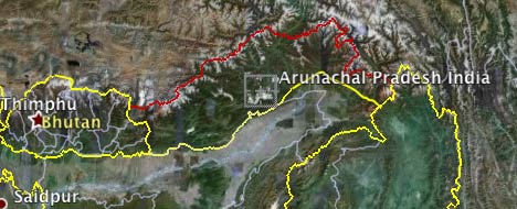
That doesn’t mean such stories can never have a justified complaint. As this piece by the Telegraph in Calcutta points out, Google Earth shows the Indian state of Arunachal Pradesh as being administered by China but claimed by India. The situation on the ground, however, is pretty much the reverse: Most of it is controlled by India, though the Chinese lay a claim to it.

Here’s the view in Google Earth:

apge.jpg

Here is the view in Google Maps:

apgm.jpg

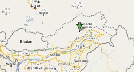
Strictly speaking, from a neutral perspective, the Maps view is correct. For Google Earth, this would translate to both borders being colored red, perhaps with an orange border depicting the line of control.

But is this coloring intentional? I doubt it. Search for “Arunachal Pradesh” in Google Earth and you will scroll to a location tagged “Arunachal Pradesh India” by Google’s own database. That’s hardly siding with the Chinese.

The article brings us another interesting tidbit, one which I’ve not seen mentioned before: The answer to the question, “How does Google decide the status of borders in disputed regions?”

“Google Earth demarcates its maps according to international standards, following the guidance of the US Federal Information Processing Standards Publication and the International Organisation for Standardisation (ISO) 3166 standards.”

I couldn’t find any actual reference maps based on FIPS, so I can’t tell if in the case of Arunachal Pradesh Google made a mistake. One possibility is that the US officially agrees with China on its claim to Arunachal Pradesh, much in the same way that the US officially agrees with China that Taiwan is part of the People’s Republic.

Media Watch: Playing the flight tracking blame game

Israel’s Haaretz has a piece out from yesterday that starts like this:

Service that allows anyone to track flights could assist terrorists

By Haaretz Staff and Channel 10

A new feature offered by Google allows anyone with an internet connection to track the flight routes of all planes arriving at or departing from the United States in real time.

For many bored surfers, this may be just another gimmick, but experts fear the new service could serve as a tool in the hands of terrorists.

That’s the introduction to a 2-minute video report that lines up a bunch of Israeli security experts berating Google for this “new feature”. (Click on the story above to see the video.)

The only problem? Nobody, not the reporter nor the experts, has any clue what they are talking about. The “feature” isn’t new, and it isn’t Google’s. It is fboweb’s flight tracking tool, available since December 2005.

This is incompetence on the part of Haaretz that borders on the unethical, as it is clearly conducive to the kind of misinformed public hysteria already evident in the comments on the piece. Next, they’ll be blaming Microsoft Internet Explorer for allowing terrorists to use chat rooms.

With all that out of the way, there is still the question: Does fboweb’s KML network links of live flight positions facilitate the work of terrorists? Such flight information is in the public domain. It takes a smart kid to write a script that scrapes coordinates on web pages and turns them into KML, so if fboweb didn’t exist, only terrorists without recourse to a geeky second cousin would be at a disadvantage. Hoping that your enemies are idiots is not the best defense… (Thanks to Jackson Pollock for the heads-up)

Virtual globe sessions at AGU listed

The American Geophysical Union’s 2007 Fall Meeting is looming — it’s on Dec 10-14 in San Francisco this year. There is a special mini website detailing all virtual globe sessions that are taking place — I count 42 presentations spread across 4 sessions (!).

I won’t be able to make it; I’ll be a the Global Knowledge III confererence in Kuala Lumpur just then, talking about public diplomacy and virtual worlds (because of my job managing Sweden’s virtual embassy in Second Life.) Who knows, maybe I’ll be able to score a cheap laptop off Nicholas Negroponte:-).

(BTW, if you visit Second Life, why not check out some virtual public diplomacy in action this coming Friday: We’re opening a new permanent exhibit on Carl Linnaeus, the famous Swedish scientist.)