DigitalGlobe removes Basra imagery from online store

What a difference a day makes. If you check out the Digital Globe Online Store now, as we did on Tuesday, you no longer get imagery of Basra from 2004 for sale, but the same pre-war imagery from 2002 that Google currently shows:

afterfgd.jpg

Also worth noting is that Mike Williams’s excellent Google Tile Comparisons tool is now off-line — though perhaps that may be due to The Register taking an interest in the story today.

The removal of the September 2004 image from the Digital Globe Online Store during the past 48 hours provides rock-solid confirmation, in my mind, that there has been a concerted effort to close this particular barn door. And without implying any normative judgment, this amounts to the first documented case of self-censorship by Google in Google Earth.

All of Hamburg goes 3D

0,1020,778957,00.jpg

Many German news sites are abuzz just now with the announcement a few hours ago that the entire center of Hamburg has been made into a massive 3D model for Google Earth. Spiegel Online has the best coverage, with photos and a video preview too. Some excerpts, translated:

“This is a world premiere,” said Google spokesperson Stefan Keuchel at the presentation of the project today. “With the textures on the facades [of buildings] Hamburg is the first city worldwide to be visible in this detail. Hamburg 3D will be live in a few days or weeks.

So we’ll have to wait just a little bit more. (More images at Die Welt.)

Looks like Denver was just practice. It will be interesting to see how fast such massive 3D models render on the average computer.

Also important to note, again, that this content is neither user generated (most models) nor Google’s own doing (like Denver), strictly speaking, but a hybrid. Writes Spiegel:

The project was not initiated bu Google, but by the Hamburg@Work initiative, which is sponsored by both the city and private businesses. Google spokesperson Keuchel said that Hamburg approached Google and proposed the project.

The stated reason: To promote tourism. Hamburg was digitized and turned into a 3D model by Cybercity AG, yet another innovative Swiss company.

Lies, damned lies, and Jerusalem’s borders

Aaron Klein’s article on WorldNetDaily accusing Google Earth of anti-Israel bias is just so depressing and dreary. But to rebut just one charge:

Google Earth states it demarcates its maps according to international standards, but no Israeli-Palestinian negotiations — even the failed Camp David final-status negotiations in 2000 — ever placed the Temple Mount within Palestinian territory.

The reason is that the border as drawn by Google Earth is several orders of magnitude less precise than the convoluted course it actually takes. That’s obvious as soon as you zoom in:

jerusalem12.jpg

This WorldNetDaily article is what happens when you mash up mapping neophytes with conspiracy theorists. What’s especially noxious, though, is to feed a terrorist commander your own deluded version of events and then getting him to congratulate Google in a quote (read the article).

The one amusing thing about all this is that elsewhere on the web, Google Earth is simultaneously accused of pro-Israel bias. Google must be doing something right to be smack in the middle of the firing line of this conflict.

Live: Schiphol flight paths + noise sensor web

geluidsnetgeneral.jpg

I can’t think of a better example right now of how a sensor web can be used to both inform and engage. In the Netherlands, Geluidsnet (“noise net” in Dutch) has a new map-based service out today with corresponding KML link that mashes up two very interesting live data streams — live airplane flights around Schiphol airport, one of Europe’s busiest; and a sensor web of noise level meters. By themselves, each stream would be interesting, but when juxtaposed as done by Geluidsnet, this network link provides a whole new level of enhanced mapping.

We’ve seen the live flight component before in the US, as done by the pioneers, FBOweb. But the sensor web of microphones, with noise levels in Google Earth indicated by the color and height of cylinders, is new to me. What is especially impressive is that both streams get updated every second or so, and as a plane flies over a specific microphone, you see the decibels spike in real time.

geluidsnetb.jpg

geluidsneta.jpg

I wondered how the server manages to support such an intense load for each computer connected, and I got the answer when after half an hour, the network link turns itself off with a message. You have to turn it back on to get another half hour. Clever.

Geluidsnet is a company that provides objective noise measurement services to both industry and communities, and is now able to provide both live flight paths and noise levels, as well as an archive of flight paths and georeferenced noise levels, so that disputes about noise pollution can be settled with reliable data accepted by all sides. Quality of life issues like these are a big deal in the Netherlands. I think Geluidsnet has just hit on a wonderful way to advertise its services, show off its technical prowess, and be entertaining at the same time.

PS This network link is most fun during the day in the Netherlands, as that’s when most planes fly. (Press release in Dutch)

Fixing Basra

I’ve been told off (politely) via email for showing terrorist readers of Ogle Earth how to get to the imagery that used to be in Google Earth by publicizing the Google Maps API tile comparison tool in my previous post. The argument was that these things may be easy for me, but not for the average Iraqi, and that what I did was akin to posting information on how to pick locks.

I only partly agree. I think my previous post was more like pointing out that there is no door to lock.

Ten minutes ago I gave myself the task of getting hold of recent imagery of Basra without access to Google Earth or the Google Maps API. I got what I was looking for on the first try. Tell me if what I just did is not accessible to anyone with dial-up internet, a point to prove, and a positive IQ.

  1. Go to DigitalGlobe’s home page.
  2. Click on, oh, I don’t know, how about The Digital Globe Online Store.
  3. Search for “Basra” in Iraq.
  4. Zoom in.

Voila.

Picture 2.jpg

Click to enlarge

Note that the acquisition date of the image is the exact same as that of the now missing imagery in Google Earth. $105 gets me an immediate digital download, $30 a month lets me surf without watermarks all I want. Or if I can live with watermarks, it’s right there for the screen-grabbing and stitching, no credit card required. Here’s the preview:

Picture4-sm.jpg

If I go for the $105 option, I get a 3000×2400 pixel download of the area — that is in fact much better than what Google Earth Free or Plus will get you. And it’s oh-so easy to overlay on Google Earth.

Of interest is that the more recent imagery, from 2005 and 2006, is not available via this method. To get at those images, you need to use the more powerful Image Library, and then submit your request to humans for vetting/preparation. I also suspect that this imagery is a lot more expensive, but I haven’t tried it. Many regional oil companies have no doubt bought that imagery in order to check up on the competition’s wells around Basra.

All this is beginning to lead me to believe that the imagery switch by Google Earth in the recent update may have been inadvertent, similar to how newer imagery of the Canary Islands was replaced with older imagery simply because a different vendor started providing it (perhaps for free or cheaply). I’ve asked but haven’t heard back from Google; in the absence of a definitive answer from them, I have to say that I think the rhetorical question “Did Google censor Basra imagery?” is now looking more tentative.

An inadvertent switch is the only explanation I can think of why other providers continue to be so sanguine about this imagery from Iraq — after all, intelligence experts have been quoted over and over since as long as I’ve listened that two-year old data is harmless, because military commanders work under the assumption that their deployments are tracked by any number of satellites, and act accordingly. Meanwhile, 2006 data is already offered for sale to the public, albeit at a price, and presumably with some checks — though I wouldn’t presume those checks are foolproof.

Did Google censor Basra imagery?

My newsreader is filling up with references to this story in the UK’s Daily Telegraph:

Terrorists ‘use Google maps to hit UK troops’

By Thomas Harding in Basra

Terrorists attacking British bases in Basra are using aerial footage displayed by the Google Earth internet tool to pinpoint their attacks, say Army intelligence sources.

Documents seized during raids on the homes of insurgents last week uncovered print-outs from photographs taken from Google.

The satellite photographs show in detail the buildings inside the bases and vulnerable areas such as tented accommodation, lavatory blocks and where lightly armoured Land Rovers are parked.

Written on the back of one set of photographs taken of the Shatt al Arab Hotel, headquarters for the 1,000 men of the Staffordshire Regiment battle group, officers found the camp’s precise longitude and latitude.

I went looking for the Shatt al Arab Hotel mentioned in the article, and found it, but saw no tents or tanks. Even stranger, Google Earth Community placemarks for Basra alluding to craters and tanks instead show remarkably intact buildings and roads. I began to think that the imagery we are currently getting for Basra is older than it used to be.

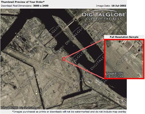
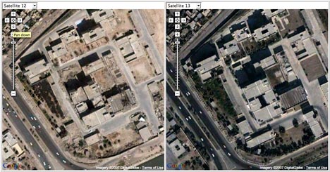
This suspicion proved correct. Here’s a comparison of what the imagery of Shatt al Arab camp looked like before/after a recent imagery update:
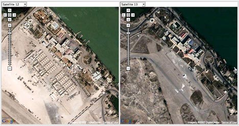
Picture 4.jpg

Click to enlarge

Currently, images in Google Earth of Basra are from 2002, months before war. Up until a recent update, the images were likely from late 2004 and/or 2005. You can tell by engaging in a little forensic mapping, using Google Earth’s built-in “Digital Globe Coverage” layer (which provides dates for its imagery), the Google Tile Comparison tool (which shows you what previous datasets looked like) and also with a little help from Google Earth Community.

For example, here is a placemark created on January 2006 depicting a crater at the former Baath Party headquarters, . If you look now, you see no crater. If you looked in January 2006, you did see a crater:

Google Earth now:

Picture 8.jpg

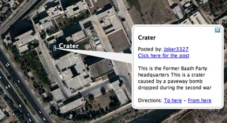
Google Maps/Earth, earlier and now:

Picture 6.jpg

Click to enlarge

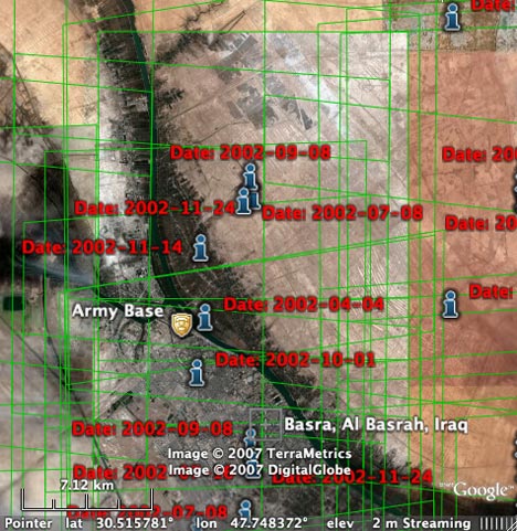
You can tell that the current imagery of Basra in Google Earth is from before the war by zooming out a bit and then turning on the “Digital Globe Coverage” layers. You’ll notice that the rectangular outline of the square over Northern Basra matches this image exactly, taken on November 24, 2002:

Picture 5.jpg

You can do the same for the rest of Basra.

When was the imagery taken that was visible at the time the placemark for the crater was made? By correlating the colored rectangles of the “Digital Globe Coverage” layer with the older dataset via the Google Tile comparison tool, you can see that before the update, most of Northern Basra is covered by this image, taken on September 28, 2004. Basra itself has yet another, cropped image overlaid on top of the one dated September 28, 2004 — and I am assuming that it is more recent, because that is the usual motivation for updating imagery.

All this raises a few questions:

1. Did Google replace newer imagery with older imagery at the request of the coalition forces in Basra? The article hints at it:

A Google spokesman said the information could be used for “good and bad” and was available to the public in many forms. “Of course we are always ready to listen to governments’ requests,” he said.

“We have opened channels with the military in Iraq but we are not prepared to discuss what we have discussed with them. But we do listen and we are sensitive to requests.”

Still, the article says the offending printouts were found “last week”. That would imply a very recent update.

2. If the use of older imagery in the new dataset is intended to thwart insurgents from using the newer imagery in the old dataset, wouldn’t it help to stop making the old dataset available via the Google Maps API? Just because these militants are mean bastards doesn’t mean they’re stupid, nor that their geeky younger brothers are unfamiliar with Javascript.

3. If this imagery was replaced by Google at the request of the coalition forces, doesn’t this rather undermine the arguments made by Google to other governments explaining why it won’t censor imagery at their request? You know, arguments such as that the imagery is a few years old, that it requires context to be useful, that it is freely available on the web, that anyone can purchase more recent imagery on the web, and that all technology is a two-edged sword — just look at cellphone detonators for bombs, cars driven by suicide bombers, GPS devices for targeting…

Finally, some other paragraphs from the article were just begging for commentary:

The British security services are concerned that terrorists will be able to examine in detail sensitive infrastructure such as electricity stations, military basis [sic], and their own headquarters in London.

Sneaky segue, that. Should everyone be censoring bits of London too, then? I see a slippery slope ahead. And then there is this nugget:

Soldiers from the Royal Green Jackets based at the Basra Palace base said they had considered suing Google Earth if they were injured by mortar rounds that had been directed on the camp by the aerial footage.

Clearly these boys aren’t Britain’s finest legal minds. Perhaps they’d also consider suing the mortar manufacturers?

[PS. this is not the first time Google Earth has been used in asynchronous warfare — they also had a go in Yemen, as reported here in October 2006.]

[Update 2007-1-18: The story unfolds thus:

Jan 16: Fixing Basra: Turns out you can still buy the imagery online via the DigitalGlobe Online Store.

Jan 18: DigitalGlobe removes Basra imagery from online store: This confirms the image is actively being removed from public access.]

Heatmaps are coming (soon) to Google Earth

A month ago, FortiusOne founder Sean Gorman said on the company blog that they would port GeoIQ, their (ironically) very cool heatmap tool for Google Maps, to KML. In a post today, Sean shows they’re making great progress. Here’s a heat map he posted correlating concentrations of single women and highly-rated bars in the Lower East Side (my old stomping ground!).

lesheat.jpg

I think this tool is going to be such a hit when it is released as a KML network link.

BTW, if you have data that you think is made for mashing up to get this kind of visualization, FortiusOne is looking for content contributors to test their new collaborative geospatial data repository, GeoCommons. This all sounds so very very promising.