Links: Australia gets roads, KML search details

  • Last week Australia got directions in Google Earth, and just now it got roads too. The alignment between road data and imagery looks good in Sydney, Perth and Canberra. In Melbourne, not so much. Thanks to the ever-vigilant Michael Smalley and Neil Grech for the heads up.

ozroads.jpg

ulururd.jpg

  • I was curious as to how KML search results might be ranked, and sent Google Earth CTO Michael Jones some questions. I see that Directions Magazine beat me to the punch:-). A good read in anticipation of a forthcoming post here on Ogle Earth. Also read Avi Bar-Ze’ev, who riffs on the metaversal implications of geospatial search.
  • What is Google Earth? It’s a stand-alone application, but it can’t live without the web. InformationWeek looks at the growing field of software-as-a-service, with functionality delivered via the web to a stand-alone client, as opposed to the browser. One danger: That we’re entering another era of platform incompatibility. The solution: Making multiplatform versions of the client, as Google Earth and iTunes do. A real no-no: Using the browser to deliver functionality, as Microsoft Virtual Earth does, but still not making it interoperable with multiple platforms.
  • Mikko at Finnish PC Security company F-Secure writes that they use Google Earth to visualize network attacks. Great anecdote follows. It turns out that the Pentagon is prepared to stop a cyber attack by bombing the source. Literally.

Links: Google buys Adscape; details on 3D Shanghai

It feels good, catching up on geobrowser news after a hectic workweek:

  • The WSJ had it right: Google is buying in-world advertising firm Adscape, for $23 million, reports Red Herring, citing “people familiar with the matter”. If you believe some of the people Red Herring talked to, it’s mainly for the patents.
  • Following up from the story in Shanghai Daily earlier this week about the Chinese 3D view of Shanghai slated for 2010, a far more nuanced and informative article on China View. For example, quoth the dev team leader Shu Rong: “We’d like to co-operate with Google Earth or other international companies, and put this technology in use.” Excellent idea.
  • New Google Earth help resources, in the form of monitored Google Groups. These replace several Google Earth Community forums. (The KML and data discussion forums stay put in the GEC.) (Via Google Earth Blog)
  • NASA World Wind 1.4 is out for the PC. Here’s what’s new since 1.3. This is a belated mention in anticipation of more time to give that virtual globe a proper whirl and a thorough review.
  • What’s the difference between neogeographers and naïve geographers? Mapping Hacks‘s Schuyler Earle explains the former concept at FOSSG4 in this video, while Richard Treves — who made the Kokae Google Earth tutorial screencasts — explains the latter concept in this writeup of his speech to the Society of Cartographers last September. In short, writes Richard, “the difference is that naive geographers are everyone, neo-geographers […] are web designers and developers without much GIS knowledge.”
  • If you have a great KML layer, building or network link you made just lying around, why not enter it in the International Digital Earth 3D Visualization Challenge? The deadline is April 1, and the finalists get an all-expenses-paid trip to San Francisco to attend ISDE5 on June 5-9.
  • Twingly is a newly launched (Swedish) blog ping service, but with a global geospatial twist. Check out the screensaver that is a virtual globe (PC only), showing off where the latest blog posts originated. It’s a very neat visualization.
  • Del.icio.us user jlawhead‘s comment on this forum thread is very funny: “I sleep better at night knowing 15-year-old nerds are monitoring Google Earth forums for terrorists.”
  • Pro tool Photomodeler is up to version 6, and with it comes the ability to export to KML. Here are the details and some examples. (It costs $1,000)
  • ArcExperts.net is Dave Bouwman‘s new aggregator for blogs by ESRI users and developers.
  • In the aftermath of the BBC article earlier this week on the usefulness of Google Earth for survival in Baghdad, the Daily Telegraph ran an article yesterday pinpointing precisely how Iraqis are using the application. I wonder if this is meant to be atonement for the hysterics the paper engaged in when it reported on the use of public domain imagery by local insurgents in Basra last month — overall, this article is somewhat more balanced than its previous attempt.
  • A new tutorial for making videos in Google Earth Pro, by the Google Earth team’s John Gardiner.
  • On this page, a treasure trove of South Africa-themed KML files (scroll down).

Chinese missile test in Google Earth — censored?

WorldTribune.com comes out with an not-entirely clear article about a graphic of the Chinese anti-missile test on January 11 — the website alleges Google “self-censored” it. The graphic, a screenshot of the missile’s trajectory in Google Earth, was produced by the Science, Technology and Global Security Working Group at MIT.

While the article never spells it out, in all likelihood what it is trying to say is that the graphic has been removed from the Chinese Google Search service, the one which removes links to content censored by Chinese censors. That wouldn’t surprise me at all, and it isn’t really news.

The upside to the article, however, is that it lead us to the actual page where the MIT researchers published their findings — it comes with the original KML file that shows the trajectory of the satellite and missile in Google Earth:

missiletest.jpg

Slightly more disturbing, however, is that in Google Earth, the region from which the missile was launched, the Xichang satellite launch center, shows signs of having been censored by Google. I can’t be sure, and I usually am sceptical of claims of censorship myself, and the Google Earth team itself maintains that it never censors imagery by pixelating or otherwise doctoring imagery, but look at the evidence: Two Digital Globe squares almost exactly overlap each other, with the top one at a highly reduced resolution. Finally, on top of all this, an unprecedented gray band that obscures all:

grayband.jpg

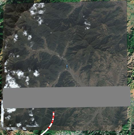
To me, this suggests that an earlier high resolution square proved too revealing, and that this has been resolved by adding a lower-resolution “patch”. Another option is that this is a data processing glitch that just happens to lie in an extremely interesting part of China. The only other explanation that I can come up with is that the US government invoked its privilege to censor Digital Globe’s satellite imagery before it was released into the public domain. Even so, there would be no reason for Google to then add this lower-resolution patch to Google Earth’s dataset, as clearly it obscures what was once crystal clear.

New: Search all the web’s KML files through Google Earth

Chikai Ohazama of the Google Earth Team posts some great news to the Google Maps API Blog today:

Users can now search through all of the world’s Keyhole Markup Language (KML) files, making the millions of Google Earth layers on the Web instantly accessible for geobrowsing and exploration. Last month, we encouraged you, our Maps API users, to create KML site maps for your mashups. Today’s launch is the next step towards making those sitemaps – and all of the world’s geographic information – discoverable by users worldwide.

Indeed, it works like a charm:

GES.jpg

There are some more screenshots in Chikai’s post.

I especially like the fact that the set of returned KML is not just what’s available on Google Earth Community — although that place surely contains the bulk some of the best KML out there. This is important if KML is going to become an open, community-driven standard sometime in the future.

Being able to do a text-based search through the KML files available on the web for a particular view in Google Earth should do to the geospatial web what Google Search did to the plain vanilla web.

filetype:kmz shackleton

[Update 17.17 UTC: Just to be clear, you could previously already do a text search on KML files using Google Search, for example filetype:kmz shackleton. Now you can further pinpoint your query to get results just near your view in Google Earth, and you can also have them returned to you as placemarks, from across many KML sources.]

Time travel in Norway with Eniro maps

Can small, local web mapping services still compete against Google, Microsoft and Yahoo!’s offerings? Absolutely. All they have to do is blow us away with cool new features:

enirono.jpg

Norway’s Yellow Pages, a part of the Scandinavian search engine and portal Eniro, has just come out with aerial datasets for 1937, 1952, 1971, 1984 and 2004, which you can put side by side and then browse in sync. Try it. (Select “Dra/Panorer” to drag the maps.)

It’s technically well thought out as well — the unique URL for each view contains the date of the desired dataset for each pane — so can send people views of your house (assuming your house is in Norway) together with a view of the area in decades past.

The possibility of having multiple historical datasets available for comparison has been mooted before: One case in India has already demonstrated how useful such a feature can be, especially if the time intervals are small and frequent. This pioneering Norwegian implementation really drives home the potential.

(Via digi.no)

Optimistic reporting — South Korea edition

Yesterday, two versions of the same article concerning Google Earth satellite imagery of South Korea:

From The Korea Herald, an excerpt:

In September 2005, high-resolution pictures of Cheong Wa Dae, the Defense Ministry and air and naval bases were featured on the site. They were deleted following a protest by the Korean government. The National Intelligence Service has recently requested the U.S. authorities to take measures curb the posting of sensitive facilities on Google, according to Seoul officials.

From AsiaMedia, the same snippet:

In 2005, high-resolution pictures of Cheong Wa Dae, the Defense Ministry and air and naval bases were featured on the site. The National Intelligence Service has recently requested the U.S. authorities to take measures to curb the posting of sensitive facilities.

Last I looked, Cheong Wa Dae (the presidential palace) was still visible. Not sure what “US authorities” have to do with any of this, in any case.

Links: Using Google Earth in Iraq, Saturn ads

  • The BBC today: Iraqis use internet to survive war

    Google is playing an unlikely role in the Iraq war. Its online satellite map of the world, Google Earth, is being used to help people survive sectarian violence in Baghdad.

    As the communal bloodshed has worsened, some Iraqis have set up advice websites to help others avoid the death squads.

    One tip – on the Iraq League site, one of the best known – is for people to draw up maps of their local area using Google Earth’s detailed imagery of Baghdad so they can work out escape routes and routes to block.

    Just don’t try that in Basra. Google Earth isn’t much help there anymore.

  • Google Earth Hacks has a new URL: gearthhacks.com
  • Business 2.0 reports that the online video ads tested last year for Saturn — which showed a video of Google Earth zooming in to a Saturn dealer near the user based on a geocoded IP address — have been deemed a success. You can expect the ads to be shown across the US this spring.
  • Google Karten is a weblog “similar to google maps mania but in german”.
  • The context is in Dutch, but this page lists plenty of good English language links to best-of-breed KML files, most of them direct links to the Google Earth Community download.
  • Another map overlay of Stockholm, circa 1885. Courtesy of the geodata unit at Department of Human Geography at KTH, the Royal Institute of Technology.