- Earth monitoring: Nature has a special issue on Earth monitoring out. Nature reporter Declan Butler blogs it, and provides links to PDFs of some of the articles.
- How now, neo geo? In case you’ve missed it, over on All Points Blog a debate has erupted as to whether neogeography is GIS or not. One unintentionally funny comment:
This “neogeo” can provide acuraccy? [sic]
The guardians of the GIS gate are wondering whether neogeographers should be let in. The problem is that we barbarians are already inside the gate, and we’re charming the socks off the good burghers’ daughters. (Andrew Turner at High Earth Orbit has more.)
- Flickr Places: Flickr’s Dan Catt explains the rationale behind the new Flickr places pages over on Geobloggers. I hadn’t quite gotten the point of these pages before — it feels less dynamic than what went before, but Dann explains thus:
The “Places” project is one that’s been brewing for quite a while. My glib reason for having them, is actually to have a page from which we can hang location based geoRSS (and KML) feeds off. I mean we have geoRSS feeds for San Francisco and so on, but up to now no-where on the site that you can get to them from.
So expect KML (network?) links soon.
That said, I’m still wishing for something that was even more versatile — GeoRSS and KML feeds for pictures that are within a certain radius of a coordinate or within bounding boxes would be my choice. That way, you’d be able to collect images from odd places like Antarctic bases, a particular stretch of coast off Ireland, or just the three block area around where I live.
- Censored in Syria? So Facebook is blocked in Syria due to Israeli “infiltration”. Zeinobia on Arabicareport assumes the reason you can’t get Google Earth in Syria is for the same reason — Syrian government censorship — but in this particular case she’s wrong. It’s US export regulations that forbid Google from making Google Earth available in Syria (and Cuba and Sudan and no doubt North Korea, were anyone other than Dear Leader to have an internet connection).
- Nice maps: Digital Urban points to “possibly the best city map in the world”, on Edushi.com. Surely not scalable, unless you’ve got cheap labor, and lots of it. If this being the Chinese century means cuter maps, I’m all for it:-)
- Hyperwords: Also at the Berlin Online Educa, Hyperwords had a stand. They are the makers of a completely free Firefox plugin that lets you do an astonishing amount of contextual menu-based actions on the words on a web page — including mapping any location name to Google Maps.
- GPS cameras anyone? CNET on whether 2008 will be the year of GPS-enabled cameras. The reporter is skeptical — GPS units need to fix their positions more quickly before GPS can go mainstream. I’d agree. Apparently, improvements are in the works.
Photosynth competition: Microsoft’s Photosynth looks like it might be getting competition, according to Wired:
Researchers at the University of Washington have developed a piece of software that synthesizes thousands of photos, digitally edits out your kids cheesing for the camera, calculates where each photographer was standing when they took the shot. By comparing two photos taken from slightly different perspectives, the software applies principles of computer vision to figure out the distance to each point. The app then stitches the photos together to create a highly detailed 3-D model of the Statue of Liberty, the Grand Canyon, or any number of tourist destinations getting snapped by the minute.
See the comments.
- ArcGIS converter: Mapperz looks at ET Geowizards 9.7, which he calls “one of the best all-round third party extensions you can get for ArcGIS.” Lots of options for converting to and from KML.
- KML@OGC feedback wanted: You’ve got until January 3 to comment on the OGC’s draft KML 2.2 standard.
- Where 2.0: O’Reilly Radar on what to expect at next year’s Where 2.0.
- Photo map choice: Locr.com, which lets you upload and geotag photos (including from your mobile) boasts it is the only photo sharing site where you can choose your map: Microsoft’s, Yahoo’s or Google’s imagery.
Yearly Archives: 2007
Géoportail gets 3D buildings, but stays closed
![]() France’s Géoportail adds 3D buildings to its Skyline Globe-powered 3D web browsing tool, which it first introduced to Windows browsers in back July 2007 (after launching the 2D version in the summer of 2006).
France’s Géoportail adds 3D buildings to its Skyline Globe-powered 3D web browsing tool, which it first introduced to Windows browsers in back July 2007 (after launching the 2D version in the summer of 2006).
The announcement by Minister of Ecology Jean-Louis Borloo says, and I translate here,
With Géoportail, France has the first European portal for accessing geographic information in three dimensions. It shows off the unique knowledge of the [state GIS agency] IGN, which has always provided cutting edge public service.
As a result, most French blogs are reporting the news that Géoportail has just added 3D, when it has in fact had it since July. (The buildings are new — as are some new default layers, like walks and georeferenced archival news videos).
And while Géoportail is indeed the first portal made by Europeans for 3D mapping (albeit by licensing American technology), it is not the first portal to show Europe in 3D. In fact, it still doesn’t. (Google Earth, NASA World Wind and Microsoft Virtual Earth came before and do all of Europe. Géoportail shows nothing beyond France’s borders.)
Géoportail certainly is much more impressive that the UK Ordnance Survey’s “outreach” effort, but both are just as closed in a time when everything online is moving towards open, interoperable, mashable standards. KML is now an OGC standard, most recently embraced by Microsoft. Where is the support By IGN and OS? Why can’t I export anything to mash up? Where are the APIs? The USGS, on the other hand, gets it.
Time to reiterate: National GIS agencies should concentrate on getting the best GIS content, acting as a repository for it, and making it accessible to all. Competing with Google and Microsoft to provide end-user services based on this content is a waste of public resources, especially as Google and Microsoft will always do it better.
Karachi property dispute turns to Google Earth
A property development dispute in Karachi got some help from Google Earth this week. The article in Pakistan’s Daily Times is a thicket of acronyms, but if I understand right, a section of a park (one of a precious few in Karachi) is being developed by the town council for housing. The council claims such development was always intended, and that the infrastructure for it was laid in the 1990s, but petitioners have managed to show in court that the construction of sewage lines is recent (and visible in Google Earth). The judge has now adjourned the case for a few weeks so that the court can “summon residents to establish the facts.” (That’s a novel concept:-)
The Google Earth Community layer labels many of the places mentioned in the article. Here they are below. Included is an educated guess as to which construction imagery the court is talking about.
Constellation boundaries for Google Sky
Thank you very much, James, for making a wish come true. Constellation borders in Google Sky — go get them at Barnabu.co.uk.
Google Earth 4.2 now out of beta
As of this morning, downloads of Google Earth are of version 4.2.205.5730 (for Mac and PC) vs 4.2.198.2451 Beta previously. I can’t find any changes to the feature set, but perhaps for the Mac version it’ll run more stably on OS X 10.5.1 Leopard. So have a download.
PS: Thanks everyone for sending me links to this article called TechCrunch Heading Towards Extinction? or something:-)
Crysis maps get help from Google Earth
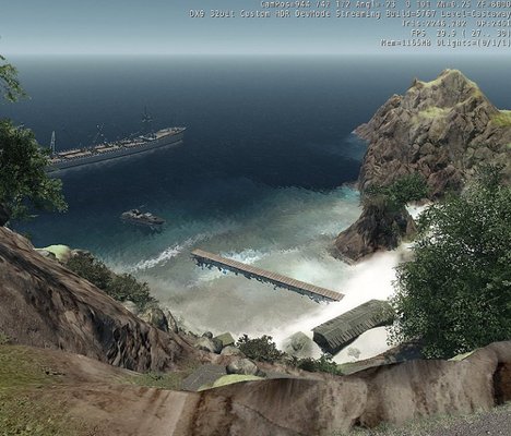
Well, wow. And how I wish I had more time on my hands. ZapWizard writes:
If you don’t know the biggest PC game of the year is Crysis. The maps are huge, and the detail intense. The game is set on a tropical island, and Crytek the company who made Crysis has released a great editor called SandBox2.
When I started making my custom single player map for Crysis, my first stop was Google Earth. I used Google Earth to make a 1:1 scale version of Monuriki, the island in Fiji used to film the movie Castaway. I used Google SketchUp to ensure things stayed 1:1 scale. The images for my island were extracted from Google Earth.I also used geo-tagged photos from Picasa as additional reference. I am even using Google Docs to write my storyline and have friends collaborate on the document. I am documenting how I made my island for other map makers by posting high-def video tutorials on DivX Stage6.
I have a flickr set of images here.
The how-to videos are here.
The project forum post is here.
Smart Boarding Google Earth in Berlin
I’m at the Online Educa Berlin conference for one of my day jobs. Some of the exhibitors are showing off their latest smart boards, and one in particular stood out for its looks — Smart Technologies‘ brand new Smart Board 600i.
I was allowed to play with it. It is very intuitive: Just touch to click, touch and move to click and drag, etc. There are also different colored pens and other software drivers that help teachers be more effective in a classroom — draw on the board and you’re also recording everything on the computer; it does handwriting recognition, there is a popup keyboard, and you can draw on top of anything the screen shows.
What I really wanted to do, however, is make my own poor man’s future user interface for Google Earth, so I convinced them to install the application. (This is how I discovered that the download process for Google Earth has been completely revamped — it now comes with an automatic updater attached). The results are below:
It’s a lot of fun to use, and it certainly made people stop and look. I found myself using the on-screen controls, which I otherwise never do, as in this kind of user interface, you don’t really control- or shift-click all that naturally. You really just want to drag the Earth around.
But at one point I also wanted to use two hands (or fingers) to rotate and zoom in on the Earth. That, alas is not possible yet with this machine. Still, if you have one of these in the classroom (and many Swedish classrooms have one) you should really consider using it for a lesson in immersive geography.
(Oh, in my enthusiasm I forgot to ask how much one of these would set me back. Their website isn’t saying.)