Social Google Earth, anyone?

Over at RealityPrime, Avi Bar-Zeev riffs and speculates on the strong hint that Google is building a social network application with a 3D component. What could it possibly entail?

Imagine it more concretely: repurpose the GE sidebar for social networking functions, “friendmarks” instead of (or adding to) placemarks, “stuff to do” instead of (or adding to) layers to view. And then let people populate and build this new fictional world however they wish, using SketchUp as the main modeling tool.

Read the whole article.

Which installation did the Israeli bombing raid in Syria target?

Which installation did the Israeli bombing raid in Syria on September 6 target?

That question has been been on the minds of quite a few pundits since news outlets began reporting on the night-time raid by Israeli jets deep in Syrian territory. At first, very little was known, as sources were uncharacteristically mum. Slowly, it became apparent that there was a nuclear angle, and a North Korean angle.

Meanwhile, can we figure out from the available piece-meal evidence what precise location this raid might have targeted?

Blake Hounshell of Foreign Policy’s Passport blog was the first to have a go, using Google Earth, no less. His georeferencing hints came from this Times of London article:

An audacious raid on a Syrian target 50 miles from the Iraqi border was under way. […] The target was identified as a northern Syrian facility that purported to be an agricultural research centre on the Euphrates river.

Hounshell then extended a line 50 miles from the border along the Euphrates on Google Earth. The line ended in Al Mayadin, which alas is not in high resolution. Hounshell’s thesis was that an area of interest to western intelligence would have been imaged by the likes of DigitalGlobe, and that it would therefore be in high resolution in Google Earth. Because Al Mayadin wasn’t, Hounshell felt that his speculation was likely wrong.

I too went looking for the possible location, and found a good candidate, but didn’t feel there was sufficient circumstantial evidence to back up my speculation. Until tonight. Hounshell was closer than he thought.

What did I do? I triangulated three pieces of information.

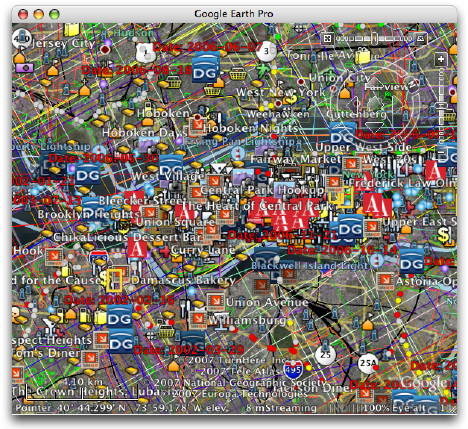
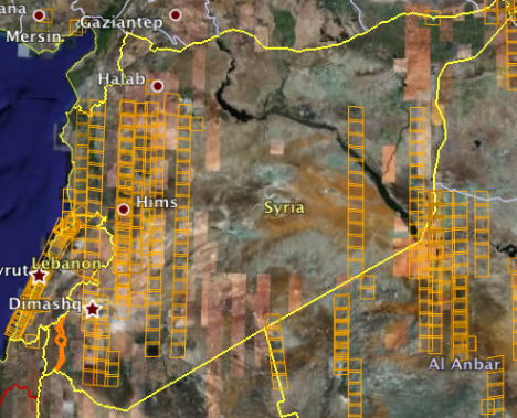
1. I turned on the default Google Earth layer showing where DigitalGlobe’s imagery was taken in 2007. This most recent imagery is not yet in Google Earth, but you can tell from the layer what area was covered:

allsyria.jpg

2. I assumed the 50-mile line was an approximation, probably converted from kilometers, and that the line from the border doesn’t have to follow the course of the Euprhates:

secondline.jpg

50miles.jpg

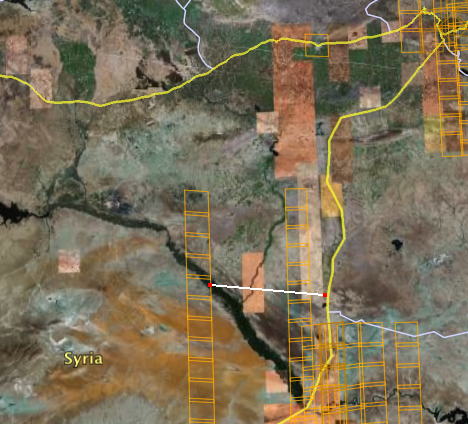
Putting these two pieces of information together, it looked like there was indeed a region about 50 miles from the border on the Euphrates where DigitalGlobe imagery had recently been taken.

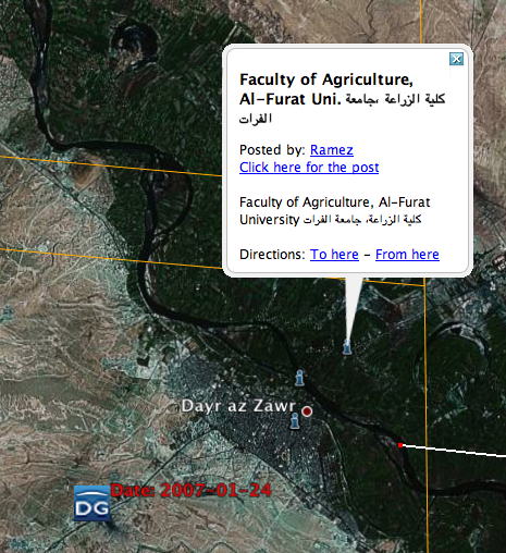
3. I then turned on the full Google Earth Community layer and went looking for “agricultural research centers” in the area that might have been annotated by one of the 900,000+ contributors. I was surprised to find precisely what I was looking for:

popup.jpg

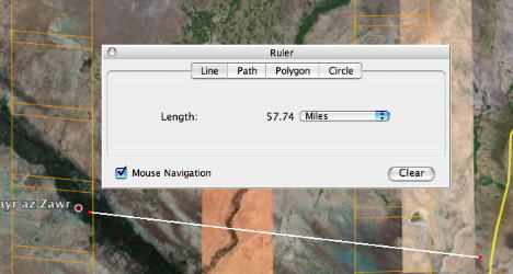
Yes, there is an agricultural research center at Dayr az-Zwar, 50 miles from the Iraqi border, on the Euphrates, underneath a strip of recent DigitalGlobe imagery. Being the skeptical type, however, I felt that this was just too speculative, so I refrained from blogging it. But tonight, the Times of London actually names the town near where the raid took place:

Israeli special forces had been gathering intelligence for several months in Syria, according to Israeli sources. They located the nuclear material at a compound near Dayr az-Zwar in the north.

This latest article doesn’t mention agriculture (and nevermind that Dayr az-Zwar is not really “in the north” of Syria) but the ensemble of information I think now makes a pretty good case the the place that was bombed was a research center of Al-Furat University’s faculty of agriculture in Dayr az-Zwar.

popup2.jpg

(Bonus Syrian WMD geography lesson: Charles Levinson at Conflict Blotter links to a Jane’s Defence Weekly report about an explosion a few months ago at a “missile installation for manufacturing chemical weapons southeast of Aleppo”, at As Safirah. Interestingly, he notes:

I was surprised while reading today’s coverage to learn that [Israeli tabloid] Yediot Aharonot actually hires the Digital Globe, a commercial spy satellite, to photograph Syrian and Iranian military installations. Apparently they’ve been doing this for years.

That’s probably why you can see the location of this munitions factory in Google Earth in high resolution here.)

[Standard disclaimer: As much of the information above comes from intelligence sources leaking to the press, any or all of it may be wrong and intentionally misleading. Read critically!]

PS: I just thought about phoning the agricultural research center in Dayr az-Zwar/Deir EL-Zoor and asking them if they’ve had any bombing raids recently, but it’s very late there right now, and besides, that would be tantamount to actual reporting, which would go against the bloggers’ ethic:-)

Links: Hasselblad2KML, OZ house numbers, Xplage, Google Sky orrery

  • My new object of lust? The Hasselblad H3D DSLR: 39 megapixels for 26.5 kiloeuros (USD$37,500) in a full-frame medium format camera. Obviously, it comes with integrated GPS and the ability to export the data as KML. Alas, it will remain the stuff of dreams.

    h3d_2.jpg

  • House numbers down under: Michael Smalley notices that streets in Australian cities get house numbers. Only in Maps (not hybrid) and not (yet?) in Google Earth.

    drumalbyn2.gif

  • Xplage: “Convert X-Plane [flight simulator] datagrams to Google Earth ‘moving map’ displays.” For Mac and Linux…
  • Google Sky orrery: Barnabu.co.uk adds a virtual orrery as a screen overlay to Google Earth, so you see the relative positions of the planets as they orbit the sun corresponding to the view from Earth at a given time.
  • Superoverlay 2.0 Beta: Valery Hronusov’s Superoverlay application for making Super-Overlays reaches version 2.0 beta.
  • North Korea watched: Here is a gem, found while trawling through the internets for georeferenced human rights material: North Korea Uncovered, “The most authoritative, publicly available map of North Korea on Google Earth”. Check out the high-resolution overlays for some of the prison camps. By North Korean Economy Watch.
  • 3D UI alert: CrunchGear has a video preview of XTreme Reality 3D, as-yet unreleased software that lets you use hand gestures in front of your webcam to control applications, including Google Earth. It’s like Atlas Gloves, blogged last year, but without the need to to use lights, as the object recognition algorithm seems to have gotten better in the meantime. (Thanks Johnathan!)
  • EditGrid collaboration: Another way to engage in collaborative mapmaking: Using the access controls of online spreadsheet applications and then converting the contents of a spreadsheet to KML. Here’s an example of how it’s been done using EditGrid to map POIs in Croatia.

Pleiades: Georeferencing ancient history

Pleiades “is an international research community, devoted to the study of ancient geography.” All the objects in its fast-growing database are referenced as GeoRSS and KML. Import Cartography‘s Sean Gillies is Pleiades chief engineer, and he has been busy stuffing the database. In high-resolution areas, placemarks often do correspond to interesting features on the ground:

telandros.jpg

There’s hours of hunting here for ancient world buffs, and especially so if you live in the area:-) Given that these placemarks have time-based period data for when they were inhabited or relevant, it would be great to eventually be able to integrate these into the Google Earth time browser via KML’s <TimeSpan> tag, so you could surf through history, seeing places appear and disappear as civilizations rise and fall.

360Cities does KML 2.2 panorama spheres

360Cities, one of a new crop of georeferenced city panorama photography sites (see also Arounder and ViewAt, reviewed here), is now using Google Earth 4.2’s ability to render embedded spheres using KML 2.2’s PhotoOverlay tag, writes 360Cities’ Jeffrey Martin. All 2,700 panoramas are being converted, but work has just started, so it will take a while. One city that is ready is Stuttgart. Check out its KML file.

stutt360.jpg

Jeffrey adds:

We’ve updated the 360cities.net homepage also – 27 cities now and many more to come. It is really turning into a monster ;-)

(See also the Gigapxl and Gigapan default layers in Google Earth for more PhotoOverlay goodness.)

Sea ice Day, collaborative mapping, privacy and access controls

Today is Sea Ice Day — sea ice being the stuff that is disappearing so rapidly from the poles. Just like when International Polar Year was launched on March 1, www.IPY.org turned a Google Map into a geographic bulletin board, where schools or institutions participating in Sea Ice Day (conduct a sea ice experiment, why don’t you?) could leave a georeferenced note — a “virtual balloon”:


ipy2007seaice tagged map – Tagzania

Some observations:

  1. These social maps have proven very popular with schoolkids and teachers. They practically fill themselves up. They are an incredibly compelling medium because within that small rectangle on the screen is an ever-expanding canvas that draws people in. We all know this, but sometimes I get jaded because it is so ubiquitous. It’s good to be reminded sometimes about the giant leaps online maps have made in the past three years.
  2. You don’t need to use the an API any more to build a social mapping application. We had users sign up to Tagzania and then told people to tag their location with a predefined tag. We then use embedded maps on IPY.org to show all the places that have the tag attached. It costs nothing and it has quite the impact — perfect for scientific outreach projects on a budget. And the Tagzania team have been very helpful in adapting the embedded maps to display more placemarks in one go, even though we’re using their site in a way it was not originally intended for.
  3. One vulnerability: We can all agree beforehand on what unique tag to use, but we cannot control who ends up using it. Currently we can’t “own” a tag or create closed groups whose user contributions we exclusively display. This opens up the possibility that somebody might want to act parasitically, attaching “tag spam” to the map.

All this leads to a wish list for social mapping sites like the already excellent Tagzania. I would like to see advanced collaborative features such as access controls and privacy controls. Perhaps some features could be free, and some you would pay for. Letting a predefined group of contributors collaborate on making a public map might be a free feature. Giving users the ability to keep such maps private or shared with specific clients (for example, for NGOs in the field) might be a pay service. It would be nice to see the same kinds of granular privacy controls that Facebook has (just to name a topical example) and apply it to geographic data. Another example: Flickr lets you have groups that are public, invitation only (but visible) or completely private. Why not do with all sorts of georeferenced data what Flickr already does with photos?

In some cases, we’re already seeing such kinds of granular privacy tools applied to online maps — especially when it comes to live tracking applications. Here is what the GMap-Track control panel looks like:

gmaptrack12.jpg

If anybody has other examples of how privacy and access controls are being implemented on mapping services sites, please do chime in with examples in the comments.

In the longer run, then, I suspect there will be more sites offering sophisticated social mapping services on top of existing mapping APIs, for inclusion on users’ own websites, so that the non-programming masses gain the use of tools that are currently only available to those rolling their own geospatial websites. The sooner that everyone’s a neogeographer, the better:-)