Censorshopping around the Netherlands

One of the advantages of having multiple companies providing internet-based maps is that it makes censorship a less feasible proposition for a government — akin to playing a game of wack-a-mole. It’s an entirely positive development for us end-users, because if the source material for the Netherlands in Google Earth is overly censored, why not try Virtual Earth or Yahoo Maps?

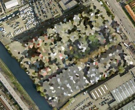
Take the example of the office of the “Dienst Vastgoed Defensie”, aka Defence Property Services department, in The Hague. The aerial photography in Google Earth and Maps was over-enthusiastically censored by Dutch authorities before being released to the public domain back in 2006:

gehague.jpg

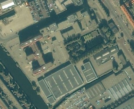
For whatever reason, the recently updated version in Microsoft Virtual Earth suffers from a much lighter censor’s touch. A medium-resolution satellite version doesn’t suffer from censorship at all (as Dutch authorities have no jurisdiction over satellite imagery):

vemedhague.jpg

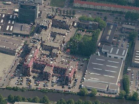
Virtual Earth’s high-resolution aerial imagery suffers censorship at a much lower grain of pixellation than Google’s, and also over a smaller area:

virtualearthhague.jpg

Ditto for bird’s eye view:

birdseyehague.jpg

Finally, for comparison, Yahoo’s Maps’ effort, a satellite image that is not censored:

yahoohague.jpg

This game can be repeated for any of the over 100 Dutch censored sites as identified by this layer in Google Earth Community. In other words, due to competition things are getting better, not worse, when it comes to tools for circumventing web-based map censorship attempts.

Links: Ipoki, Geoflock, OS in GE, C-GPS2KML

  • Ipoki: The idea of letting friends know where you are live on the map and following friends around yourself is a pretty seductive one. I’ve been using GMap-Track on this blog to update my whereabouts, but that application is not the only player in this geosocial application space. Now there is Spanish-origin Ipoki, newly relaunched (it used to be called hipoqih) and ready for the big time. Ipoki works as a small application on GPS-enabled phones, or you can also set your location manually from the website.

    The functionality of Ipoki and GMap-Track is very similar: Both have privacy controls, people search and the ability to let you embed a live location map on your website. Ipoki has a few more Facebookish features, such as a “what you are doing” status line you can fill in and commenting features. Ipoki also lets you view your friends as a live KML network link, and lets you link to unique permalinked pages to track individual users (I am at www.ipoki.com/maps/belmeloro).

    But GMap-Track’s phone application, Mobile Gmaps, hasn’t been standing still — the latest version allows you to load KML files direct from your memory card, which is a great way to take KML data into the field with you. (Extra tip: Use Gmap-Track’s public map to compare Yahoo, Microsoft and Google’s map offerings, as all are available to choose from.)

  • Geoflock: Got Flock? It’s a newish, free social-networking savvy browser that appears to be having something of a resurgence. If you do, get Geoflock, a plugin that gives you a wealth of mapping tools within the browser. For example, it can

    Create and save a sidebar map using the addresses or address links you find on web pages, or by manually adding locations. Show traffic Info, drag and drop kml files and geotag Flickr photos within the Flock photo uploader. There is a great deal of additional functionality which is hard to sum up, such as automatic geoURL/geotag discovery, support for Google Earth, Platial.com, getting directions; loc.alize.us…

    Automatic discovery and viewing of maps relevant to a web site is a great bit of functionality, methinks.

  • Ordnance Survey in Google Earth: Ah, finally, UK’s Ordnance Survey’s mapping tiles are put to use in a productive manner — as a dynamic overlay in Google Earth, thanks to Gavin Brock. No doubt this breaks all manner of EULA, but check it out in the meantime as an example of what the data could do it if it were open and freely accessible:

    scafell.jpg

    (Via Naquada)

  • GPS2KML: C-GPS2KML is not the first application to convert GPS logs to KML, but it does have an impressive feature set and a myriad of display options. It’s free, comes in Windows and Linux versions, has a detailed manual, and the screenshot eye candy is very enticing. Check it out. (The only competitor I can think of when it comes to similar customizable display options is the web-based app GPS Visualizer)
  • Virual Earth dataset update: Microsoft Virtual Earth comes out with another mammoth dataset update, including 15,000 square kilometers of 3D urban landscapes (almost all of it in the US) and heaps of bird’s eye views, aerial and satellite imagery (a bit all over).

    Reaffirming a previous observation: Microsoft’s data gathering priority is above all urban areas, and primarily the developed world, whereas Google’s collection is far more indiscriminate — but in a good way: If, as Thomas Friedman argues, “the world is flat”, this is in part because even out-of-the-way places can now finally get equal footing in the cartography stakes.

  • ESRI ArcGIS Explorer update: James Fee points us in the direction of a new release of ESRI ArcGIS Explorer — Build 440. My favorite new feature: Popups can use a full complement of HTML tags, including Javascript and CSS! Now wouldn’t it make everyone’s life easier if KML supported that?!
  • Geology visualization: Frank at Google Earth Blog and Richard Treves at Google Earth Design write up a great new geology visualization technique using Google Earth by Declan De Poar of Worcester Polytechnic Institute, presented at the AGU’s annual conference last week.

Imagery update: New context for Egypt, Zimbabwe

Google has posted the list detailing the imagery and terrain update from December 16. The list is reproduced below the fold for archival purposes.

Several of these updates provide some great new context to existing stories. For example:

Egypt: A big chunk of Egypt gets 2.5m resolution imagery, so this is a great time to once again check the KML file of my field trip to Wadi el Hitan, Whale Valley, from May 2007. The remote shallow valley, which contains fossiled 40-million year whales, was previously in 15-meter resolution, and the imagery did not include the new road. Here is the before and after imagery:

wvtrace.jpg

afterwhalevalley.jpg

Harare: The wholesale depopulation of a neighborhood of Harare was documented by the American Association for the Advancement of Science (AAAS) back in 2006. Google’s base imagery is now in high resolution, proving a third data-point for the KML layer.

Continue reading Imagery update: New context for Egypt, Zimbabwe

Links: Google Earth in cartoons, and as art

  • Google Earth and mainstream consciousness I: Ubikcan flags a recent Doonesbury cartoon by Gary Trudeau highlighting the use of Google Earth to track human rights violations.

    doonesb.jpg

    (Read the whole thing)

    Ubikcan highlights to another one from the New Yorker a few months ago that I had not previously noticed. And while we’re on the topic, let’s not forget one of my all-time favorites, the Ogle Earth cartoon in the New Yorker from 2006?:-)

  • Google Earth and mainstream consciousness II: Sydney art collective The Glue Society produced a work that consists of retouched satellite imagery to depict biblical mythology. Says Glue Society’s James Dive: “We like to disorientate audiences a little with all our work. And with this piece we felt technology now allows events which may or may not have happened to be visualized and made to appear dramatically real. As a method of representation satellite photography is so trusted, it has been interesting to mess with that trust.” Click here to see their work as depicted on Creative Review’s blog.
  • Mapping in the dark: What about using maps in the dark, for example when driving? IDVUX blog discovers a genial solution — run a color-inverting filter on the client side:

  • KMLer update: The latest version of Valery Hronusov’s KMLer 2.0 ArcGIS extension for Windows supports extended data fields. ($20-$50)
  • Mac geocoding I: Mac photogeoreferencing tool HoudahGeo is up to version 1.3. ($25)
  • Mac geocoding II: SnapMap is an upcoming application for representing your photos in 3D and across a timeline. There’s a video demo, and they’re looking for beta testers.
  • Dedicated IGC viewer: For hang-gliding Windows users with .Net installed, a tool for replaying your flights’ IGC files that has dedicated controls and views that uses the Google Earth engine. This thread on OZ Report discusses the application. (You could also use a web-based IGC-to-KML converter or IGC2KML. (the latter comes recommended by OZ Report’s Davis Straub.))

Google Sky API: Early usage examples

Google Maps’ API now officially supports Google Sky imagery. HeyWhatsThat takes quick advantage of this to make a planisphere tool for the web. Alasdair Alan ar The Daily Ack, meanwhile, spends a productive weekend playing with the API to 1) make it compatible with PLASTIC, an emerging protocol for communiication between astronomical applications, and 2) make it work on the iPhone. All very impressive!

[Update 2:40 UTC: The possibilities are only just now beginning to percolate through: In a few months, when the iPhone SDK comes out, why not view astroreferenced news on your iPhone with Google Sky, and then (here is the cool bit) control your telescope with the iPhone to get it to view the location in question automatically!]

Antarctica: Start adding content

The most recent imagery update for Google Earth now includes the recently released 15-meter resolution LIMA imagery for much of Antarctica. Antarctica is looking pretty empty right now when it comes to default layers, but if you download the International Polar Year website’s KML layer, you can get daily updated georeferenced posts from scientific expeditions on Antarctica, including from the Norway-US Antarctic Traverse, which is currently on its way to the South Pole. Soon the layer will also include georeferenced posts by the research ship Polarstern, so keep that layer handy!

antarctictraverse.jpg

Intel Classmate gets the map test

Back in June I had a chance to play with the One Laptop Per Child (OLPC) computer, and used the opportunity to check out which mapping sites worked on its browser. (Google Maps and Yahoo Maps Classic worked, Microsoft Virtual Earth did not.)

In the past few months, Intel and Microsoft have been touting a competitor, the Classmate, which runs Windows XP. Intel and Microsoft, both big sponsors of Global Knowledge 3 here in Kuala Lumpur, were showing off Classmates. I got to play with one. I’m sure you’re dying to know — does it run Google Earth? Virtual Earth in 3D?

20071211362x500.jpg

I like the look of the Classmate. It is small and feels rugged. Spec-wise, Classmate and OLPC are similar in terms of RAM and NAND flash storage, but the Classmate suffers from a really small screen — 800×480 pixels (color). OLPC gets 1200×900 pixels (color).

Because the Classmate runs Internet Explorer on Windows XP, all the mapping sites loaded, though in all cases, the small screen meant that the actual map area of the web page was miniscule.

20071211364x500.jpg

I installed Google Earth — the process went without a hitch. How does it run? As expected, because classmate has no graphics card, frame rates were very low:

As for Microsoft’s Virtual Earth 3D, i never got the installation process to finish. Of course, it was very unfair of me to try this on a sub-$300 computer, but one can live in hope:-)

Which laptop will be more successful? I suspect that the developing world’s government education agencies will likely go for the Classmate because of the familiar Windows on it. Children, on the other hand, will care more about the cool screen. One BBC reporter who has been skeptical of the OLPC found that his kid loves the OLPC. Also, at half the price, you get more OLPCs than Classmates for your money, though you could also just wait 18 months for Moore’s Law to do its thing. In the end, it’s the OLPC that wins my heart, as it is such a radical departure from traditional laptops.