3DWarehouse2Arc2Earth

a2e3dwh.jpg

3D Warehouse content can now be downloaded directly into Arc2Earth, the ArcGIS to KML exporter, where you can use it as a replacement for marker icons. The killer feature is this: Arc2Earth can restyle the content according to the markers’s attributes. Writes the developer, Brian Flood, on his blog:

A2E can use this [attribute] information to “re-style” the model in part or in whole. In this regard, the models become more dynamic since they can be styled to display all different sorts of data. Likewise, the models can be scaled and rotated by fixed or attribute defined values. So style, size, orientation and clearly location are all dynamically applied during the export.

Plenty of examples over on Brian’s blog.

VlogMap gets an upgrade, hits the big time

Another blog post that just writes itself. Matt of VlogMap emails:

I just wanted to let you know that I just launched VlogMap 2.0… The launch was pushed up 1 month due to being printed this month’s issue of Wired Magazine. The main reason I’m emailing is to inform you of a new feature…

Not only can vloggers map their video blog sites, but they can now map their individual video posts as well. I’m calling this “geovlogging” and it allows visitors to virtually travel to a location and watch videos from the exact location they were filmed…

For example, lets say I’m headed to Tunisia this summer. I can browse the map to see a community member (Andy Carvin) has mapped a bunch of videos from his trip…

And of course, the data is also available in Google Earth

That’s great news for vloggers, and also for Google Earth users. We now have a network link for individual vlog “entries”, above, as well as a network link that anchors entire video blogs to the authors’ home bases. The disaggregation of georeferenced content into ever-more precisely positioned components continues apace.

At first blush, it might appear strange that tools for georeferencing photos and videos have gone mainstream a lot faster than tools to help text bloggers (wow, sounds so ancient:-) georefence their posts, but perhaps the reason is that photos and video snippets are clearly of a place, whereas text has a nasty habit of wandering all over the place. Text is often abstract, while photos and videos often aren’t; the “where” attribute is more front-and-center for a photograph or video than for a piece of writing.

Short news: RoboGeo v4.0, Google Ocean, Astun Tech geocodes

  • Some highly lickable SketchUp models of hypothetical MIDI controllers, posted to Make:.
  • Photo georeferencing tool for Windows RoboGeo makes it up to version 4.0, with an enhanced user interface, automatic support for camera directions (!), and better image stamping. There is a free demo version.
  • Google Ocean is a collection of Google Earth files with a maritime theme: Buoy data, sea surface temperatures, weather, bathymetry data, tidal predictions, shipwrecks… There is also a set of high resolution overlays for the French coast line. The pièce de resistance? Submarine cables have negative height numbers in anticipation of Google Earth getting real 3D seafloors (!).
  • Astun Technology has come out with a very slick, free, javascript-based batch geocoder. It claims to be able to geocode addresses globally (specializing in the UK), and you can get the output as KML. If you need industrial strength solutions (or integration with your website), you can subscribe to a commercial solution.

Geotaggers.com, anyone?

Dimitri Stancioff posts to Flickr’s geotagging community:

A short while ago I nabbed the domain name geotaggers.com. I have been developing an application to view Flickr photos in Google Earth (much like the late Geobloggers.com and Yuan’s solution) and I figured that was where I would host the download from and run the service from.

Recently, however, I have started to consider creating a site that is an overall resource for geotaggers. One site that is maintained and updated to provide a resource to anyone interested in geotagging, whether they come from flickr, del.ico.ous, or other community based tagging sites.

So I am asking here what people feel that they need, or would like to see, compiled into one location.

Read his entire request for ideas.

Google Earth sweeps Webby Awards

webbylogo.jpgThe Webby Award winners have been announced, and Google Earth sweeps it, winning both categories for which it was nominated, twice each. Google Earth wins the “Broadband” Webby, and also the People’s Voice award for that category. And Google Earth snags the “Best Visual Design — Function” Webby, as well as the People’s Voice award there too.

Google Maps wins the “Services” Webby and People’s Voice Award, and also the People’s Voice award for “Best Practices“. (Flickr wins the Webby there). Congratulations to everyone involved — seven awards by one development team must be some kind of Webby record.

(And a special shout out to fellow expat Belgian Régine Debatty, the talented blogger behind We-make-money-not-art, which won the Webby for “Blog — Culture/Personal“.)

Interview: Brian Timoney, Google Earth developer

TimoneyLogo.gifThe Timoney Group has been responsible for groundbreaking demonstrations of Google Earth’s usefulness as an analytical tool — Envisioning Jonah Gas, South American Trade (a collaboration with Eicher-GIS) and now Gulf Impact.

In this interview with Brian Timoney, I ask him about what it means to be a Google Earth developer, why he uses open-source tools, what the strengths and weaknesses are of server-side processing, and whether SketchUp has a role in GIS.

Ogle Earth: In a few sentences, what did you do before Google Earth came along?

Brian Timoney: I come from a GIS background working in the environmental, petroleum, and military contracting fields. The primary impetus for starting my own business, interstingly enough, was as much organizational as technological. Specifically, there was a disjunct between the sophistication of the tools being used at the analytical level and the static output (99.9% of the time a paper map) being used at the decision-making level.

Continue reading Interview: Brian Timoney, Google Earth developer

Advanced hurricane impact analysis, with Google Earth

preview_pathbuff.jpg
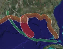
Brian Timoney and his group have released another impressive demonstration of Google Earth’s usefulness as an analysis tool — Gulf Impact: The energy impact of Rita and Katrina. It lets you upload a hurricane path in the Gulf of Mexico (or use the supplied path for Katrina or Rita), specify a impact zone of arbitrary size around it, and then have the server calculate the amount of oil and gas production that such a hurricane would affect inside this zone. All this is then rendered onto Google Earth, with plenty of additional static layers for context.

Brian explains it a lot better on his site, and in any case you really need to see this in action. Coming up next: An interview with Brian Timoney.