Binary Bonsai has a good point: Microsoft already has a true 3D mapping application: Microsoft Flight Simulator X: Here are some awesome screenshots.
Monthly Archives: January 2006
Quick tutorial on network links (using Flickrmap as an example)
One thing I noticed about Mark Zeman’s otherwise excellent Flickrmap multimedia tutorial (see previous post) is that he spends a good deal of time at the start explaining how to set up the network link that allows you to use Flickrmap with Google Earth. Indeed, setting up a network link can be quite tedious: Add Network Link from the menu, right-click on it, choose edit, change the name, type a longish URL, set refresh preferences… It’s not rocket science, but it is typo-prone, and perhaps a bit overwhelming for beginners.
But there is an easy way to circumvent all this if you want others to have a network link to your precise specifications:
First, set up the network link exactly as you like it. Then, right-click on it, choose Save As, select KMZ as the file format, and save. The resulting KMZ file, when opened by anyone with Google Earth installed, will automatically result in your network link appearing in their Temporary Places, no setup required. KMZ files are zipped, so they are mailable, downloadable, uploadable, linkable, etc… So instead of telling people how to make a specific network link, you can just give them a link.
Why is it so simple? Because network links are just a piece of KML markup. Mark’s Flickrmap network link, for example, looks like this:
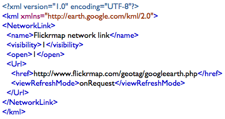
(I got this text to reveal itself by saving the network link in Google Earth but choosing KML as the file format, which is just a text file format. I then opened the resultant file in a text editor.)
So, to make a long story short, here is Flickrmap’s network link [KMZ] for you to download and start using in Google Earth right away.
(For extra credit: Network links themselves don’t have to be static files. GEWar, for example, provides each new player with a dynamically generated network link. Each network link points to a different URL, in effect giving each player their own unique view of the game.)
[Update 2006-01-07: Mark reports that he’s fixed it and changed the tutorial to reflect this.]
Flickrmap
Geotagging Flickr photos has proven to be a hugely popular pursuit, with over 100,000 images tagged to date. You can display geotagged photos in Google Earth using the most excellent Geobloggers site’s network link (temporarily down for renovations and boy do we miss it), and there are several ways of easing the geotagging task: Marrying GPS data with a digital camera’s EXIF data, Steeev’s script for using Google Earth (apparently broken by the latest version of Greasemonkey), standalone Windows application ITag, and .CK’s GMIF script for using Google Maps. (More info and links at the GeoTagging Flickr group page.)
Now, New Zealander Mark Zeman has taken the geotagging concept to a whole new level with Flickrmap, a properly ajaxified web application that does several things: It lets you show your geotagged Flickr photos on a map on your own website or blog, it lets you use Google Earth to geotag your photos, and it acts as a geotagging “manager” for your Flickr photos.
The integration with Google Earth is seamless and impressive, but I think the cleverest (and genuinely innovative) feature in Flickrmap is that it will automatically convert placename tags into geotags. For example, if you have a photo that is tagged “Paris France”, Flickrmap will suggest the correct geotags for you to add. You can then use Google Earth to pinpoint the location, but you don’t have to if you don’t want to — your Flickrmap map will already locate that picture in Paris.
Mark explains it far better in a multimedia tutorial. Worth watching, even if you don’t geotag photos, just to see what you can do with Google Earth, Flickr, and a healthy dose of ajax.
[Update 2006-01-07: As Ole points out in the comments, Flickrmap is not the only geo-spatial solution for photos. His post has a long list.]
Nature publishes every avian flu incident globally as a KML network link
Nature has published a mammoth avian flu database as a KML network link. It’s easier to let Declan Butler, the reporter at Nature who built it, explain (which he does on his blog):
Nature has a Google Earth map of avian flu outbreaks online tonight. The visualization of avian flu outbreaks is the first online map, to my knowledge, of each of the more than 1800 individual outbreaks of avian flu in birds that have been reported over the past two years. It also provides a geographical overview of confirmed human cases of infection with the H5N1 influenza virus. The network link is available here and on the GE forum, here.
Declan spends the rest of his post outlining his methodology and sources. He also links to other avian flu maps.
The contents of Nature‘s avian flu network link are byzantine. In addition to their obvious medical and educational benefits, they show up two things about Google Earth: The application’s strengths, and the application’s current limitations.
The strengths are clear: Google Earth was built to visualize exactly this kind of data, and the way network links work ensures that the data stays up-to-date on every installation that has it.
The limitations are as follows. One of them Declan also notes: The Places panel’s nested folder GUI model overwhelms the user when a dataset gets to be this large. In fact, it overwhelms if you simply have too many network links and placemarks listed, whether they’re activated or not. Nested folders worked as a navigation tool when only a few datasets were on offer. But KML is taking off like wildfire. Imagine trying to surf the web by using only the links in your nested bookmark folders in your browser — no following hyperlinks to other sites allowed. You could for a while, but you’d go mad quite quickly.
The solution, I think, is that the Places panel needs to be complemented by an interactive browser window, in which such information can be portrayed more intuitively. We’ve recently had a taste of what that can be like. I think it’s the way to go. The Places folder will then become the equivalent of the bookmarks pane in web browsers: Useful, but not the focus of navigation.
The second limitation is that Declan’s data is screaming for time-line based display: the incidents of avian flu come with dates, so they should be showable in succession, adding an entire dimension to the publishing of the data. Google Earth can’t do that. Yet.
But it might soon. There are undocumented KML tags that allow for date- and time-stamping, and Google CTO Michael Jones has already displayed a prototype of a “time browser” for Google Earth. When that gets added to a future version of Google Earth, Declan will be able to use it simply by retagging data he already has in his database. It will make for quite a showcase:-)
Fact checking is a good thing
Lone amateur bloggers can (sometimes) be forgiven for getting the facts wrong or riding a meme without verifying sources, but pro blogs and blogs associated with professional publications shouldn’t get off so lightly, in my book.
So for the record: Preston Gralla’s post, on TechWeb’s Networking Pipeline site, VP Cheney To Google: Who’s Your Daddy?, is fiction. Most likely, it’s due to his ignorance of how such imagery is collected.
And while we’re on the topic of corrections: Maureen Dowd is not the New York Times. Dowd is a columnist free to espouse the most outlandish conspiracy theories, while The New York Times has its own editorial voice and news service, and is in the habit of fact checking (recent lapses notwithstanding).
Google defends Earth
Another day, another well researched and accurate article in the Hindustan Times. Google seems eager to set the record straight, making both International PR manager Debbie Frost and Senior Policy Counsel Andrew McLaughlin available for interview. Their arguments will be familiar to readers of this blog, but it’s good to have the following on the record, courtesy of McLaughlin:
“… The US government has never made any request that Google make changes to the Google Earth service. Nor to date has any other government formally requested Google to remove or obscure particular places.”
(Via lastingnews.com, again)
Yes, we have no pool at the White House
French newspaper Le Figaro has an article on censorship in Google Earth, Maps and NASA World Wind. Despite the slightly breathless title (in English, “Censorship scrambles maps on Google Earth”), the article is quite balanced and accurate, mentioning that updates to Google Earth’s data have replaced censored images with uncensored images (with the exception of the Vice President’s residence.)
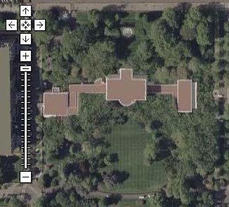
One thing it points out, and which I hadn’t noticed before, is that the earliest, censored imagery of the White House (still visible on Google Maps today) didn’t just replace the roof of the White House with beige rectangles — somebody went and photoshopped the pool and the Rose Garden with trees as well. Look:
Maps:
Earth:
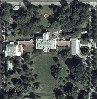
Now isn’t that special? To me, there is a big difference, in a democracy, between clearly marking an area as censored (for whatever dubious security reason) and actively falsifying information. The latter action is tantamount to lying to one’s own citizens, and is not qualitatively different to KGB efforts to erase out-of-favour figures in photos. If the pool is crucial to national defence, by all means pixelate it, if you really have to. But pretending that the president does not have a pool, and not realizing the difference between censorship and falsification, is creepy.