If you’re a serious photographer, you might use the IMatch image management tool. If so, you’ll like some scripts that have been written for that app, integrating georeferenced images with Google Earth. (Via Aaron B. Hockley, who provides some added context.)
Monthly Archives: January 2006
QTVR & Google Earth
One of the most visually stunning websites about Sweden is Virtual Sweden, which contains a wealth of 360-degree QuickTime VR images, and not just of Sweden.
The most recent images have a link to the actual location in Google Earth, so you can now fly to the precise location as you immerse yourself in a Swedish panorama.
One of the earliest additions of content to Google Earth involved Berkeley University’s global QTVR library, back in July 2005. The KML file is still available (KMZ) , and it still provides one of the most immersive experiences available using Google Earth. Here is the original blog post.
Semapedia
Last week, Ogle Earth came across Navizon, which connects physical places to user-created content on the web using GPS, wifi, and cellphone signals. We wished for a view from Google Earth, however.
Now check out Semapedia: the concept is just as innovative, but doesn’t rely on wireless positioning technology to link the real world to the web. Instead, software for Java-enabled cameraphones lets you take pictures of special digital tags attached to physical locations — this takes you directly to the related wikipedia article. What’s more, the project is deeply collaborative, with anyone able to print out tags for any georeferenced wikipedia article and affix them to the location.
This has the potential to turn the world into a giant museum gallery, with your phone as the guide. The project is just 6 months old, so there is still plenty of tagging to be done; this is why the brand-new Google Earth view (KML) is so handy (blog announcement). All those tags that do exist are locatable via the KML file. Note, however, that this file is not a network link, so you’ll have to make one yourself if you want the info to update automatically. (How?)
Some thoughts regarding this sudden meme:
1)Wireless telcos will love it, as both Navizon and Semapedia encourage the use of your mobile phone’s internet connection.
2) Navizon and Semapedia have a different method for geolocation and a different content set. There is no real reason why these methods and the content aren’t complementary, however. In the long run, I expect they will be — there will be multiple ways to connect the physical to the virtual, and for different purposes.
Google Earth, cartoon fodder

Get there via The Heaviest of Boots.
Damocles, take 2
Remember the Damocles Arctic sea ice project I blogged last week? The page associated with the Google Earth network link (KMZ) is now looking a whole lot more informative — explaining precisely what all the data types portrayed are.
While you’re playing with the network link, be sure to turn on the AMSR-E total ice concentration layer for a very colorful and informative take on the effect of the Gulf Stream on the sea ice. All this is of course screaming out for time lapse motion. (Thanks to Pierre-Philippe Mathieu at ESA for the original heads up. Is ESA’s EOMD planning anything with Google Earth, BTW? Can’t let NASA have all the fun:-)
The Oz Report, now via Google Earth
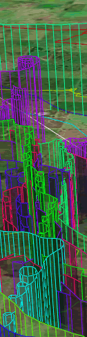 The Oz Report, a website fanatically dedicated to all things hang gliding and paragliding, has been implementing Google Earth functionality in some very interesting ways.
First, the site maintains an exhaustive library of global hang gliding sites, viewable both in Maps and as a network link (KMZ). Most locations have a link to information about the site.
Second, the Sportavia International Open hang gliding competition is currently underway in Australia, and each day, The Oz Report adds the flight paths of competitors to this network link (KMZ). While we’ve seen Google Earth used for something similar before (the XAlps), the paths drawn by The Oz Report in Google Earth are a big improvement in terms of visualization, and very pretty to boot. (You can even fly along the paths of individual hang gliders. Instructions are here.)
RoboGEO gets an update
RoboGEO really has quite a few tricks up its sleeve when it comes to georeferencing photographs. It aready provides Flickr users with Flickr2Map, a free service that links geotagged Flickr images to their location in Google Earth, Maps, and other apps.
RoboGEO also makes a standalone PC application that lets you marry GPS data with pictures in many different ways — version 3.1, out today, intergrates with Flickr and can handle Google Maps’ new API. (It already does KML, obviously.)