Here are some interesting stories that have popped up on the radar screen these past few weeks:
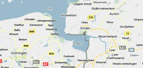
Strange Maps (Mar 1): 504 – Bordering on Bizarre: Google Maps Fail in Dollart Bay
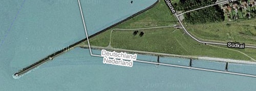
You’d be forgiven for thinking that border disputes are not something that neighboring European Union members get embroiled in. You’d be wrong: The Netherlands and Germany diverge on where the maritime border between them lies. One thing both sides agree on, however: The way Google Maps currently depicts the maritime border is wrong:
It gives the Netherlands all of the maritime territory in question, including the harbor of Emden, a German town. The error is only visible in Google Maps. Google Earth (sensibly?) doesn’t try to depict maritime borders. Emden city council, meanwhile, has been trying to alert Google for the past year, clearly without success.
Associated Press (Feb 21): Google Street View raises Israeli security fears
Jerusalem Post (Feb 20): In Israel Google Street View needs serious thought
As the Associated Press reports, Israel’s government would like for Google Street View to come to Israel, but first wants to work with Google to minimize security risks. The Jerusalem Posts column proposes how this collaboration might work, but the suggestions are a bit… bizarre?
Keeping the data in Israel is the only way to ensure the Israeli courts can order enforcement. This may be a good first step. Israel also has a responsibility to act in the Interests of its people and of the Jewish people more generally. In light of that, Israel may also request further unrelated guarantees from Google, such as an undertaking to cooperate more fully with the Ministry of Foreign Affairs in the fight against Antisemitism.
First, if Google had to keep the only copy of each country’s geospatial dataset in that country, there would be no Google Street View or Google Earth. The data resides in redundant server farms around the world. If Israel wants to have a legal grip on Google, I suggest looking in the Tel Aviv phone book for their offices.
Second, I’m sure that Google is against anti-semitism, as they are against racism and homophobia, but this is an issue wholly unrelated to Google Street View, as the JPost op-ed piece concedes. Then why connect them? Holding up regulatory approval in one matter until a company concedes on an unrelated matter is called being held to ransom.
ISIS Reports (Feb 23): Satellite Image Shows Suspected Uranium Conversion Plant in Syria
Remember that North-Korea designed nuclear reactor under construction in Syria which Israel bombed in September 2007? Germany’s Sueddeutsche Zeitung has now identified a further site that was related to the reactor, and whose purpose at the time Syria now seems to want to hide. ISIS has now commissioned imagery to further analyze this site.
Google Lat Long Blog (Feb 15): Act Locally in Sudan with New Imagery & Maps
Google releases new imagery for soon-to-be newly independent South Sudan, and urges the creation of local mapping communities in both Sudans.


Hello, nice article, just start took you to suqatrah?…. How lucky are you, is it as beautiful as that say?