- FlickrExport 3: Connected Flow’s FlickrExport 3.0 for Aperture and iPhoto has finally come out of beta. It gets a mention here because among the improvements we get:
– GPS track log integration – download your GPS tracks and connect them with photos as you upload them (supports GPX and NMEA).
– Geolocation presets – store a location and recall it with one click.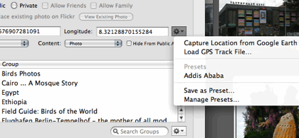
You can also set the location from the current view in Google Earth. All this is useful if you want to make a quick and dirty geotagged set on Flickr, but the georeferencing feature does not save the location to Aperture’s database (and I presume not to iPhoto either) so I won’t be using it, in favor of georeferencing solutions that change the metadata of the original image.
- Google Earth tours: Google Earth Design‘s Richard Treves takes you through the required steps for making a simple tour in Google Earth 5. Meanwhile, Google Earth Blog has a nice roundup of some well-made tours.
- China to launch own virtual Globe: China Economic Net reported earlier in February that China’s State Bureau of Surveying and Mapping is going to build a domestic counterpart to Google Earth. According to the article, it will be censored, but carry more high resolution imagery of China than Google Earth. Just like India’s Bhuvan, then.
- Imagery Update: Google Earth Blog and Google Lat Long Blog alert us to the latest Google Earth imagery update.
- SketchUp for Google Ocean: An update to Google SketchUp 7 lets you place models underwater in Google Earth 5. Here’s how.