The National Snow and Ice Data Center (NSIDC) at the University of Colorado Boulder has begun experimenting with KML as an alternate means of visually depicting data for their State of the Cryosphere (“Where the world is frozen”). The KMZ file is officially in beta, but is already a beautiful piece of work. It contains:
- An overlay with near real-time daily global ice concentration and snow extent.
- An overlay showing the extent of permafrost and ground-ice conditions in the northern hemisphere.
- A placemark collection of glaciers in the Americas and Europe.
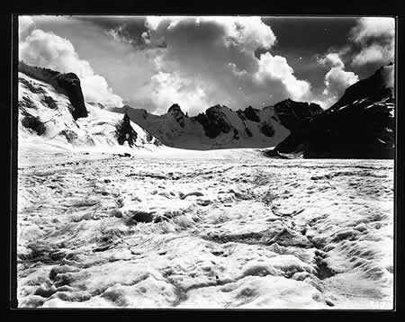
The placemarks contain thumbnails that link to a database of amazing historical photographs of the glaciers, dating back all the way to 1896. You can even request extremely high-resolution TIFFs of some of these and they are freely usable if properly cited. (Unfortunately, a bug prevents image hyperlinking in the Mac (beta) Google Earth client, so Mac users need to get the images manually.) Here is a deep link to whet your appetite — the Forno glacier in 1896:
A subset of these placemarks contains paired images — one old and one new, taken from the exact same vantage point — so that you can see how far the glacier has receded in the intervening decades:
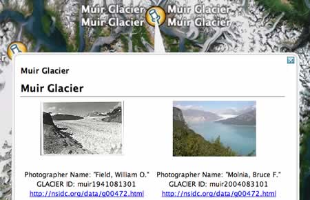
(Here are these pairs on the web, rather than on Google Earth.)
The big picture: If you’re a scientific research institute sitting on georeferenced content, converting it to KML and releasing it onto the web easily constitutes the biggest bang for your outreach buck.
have a look at http://www.geostrategis.com/p_mapm2.html.
I have studied the melting of permafrost between 1926 and 2005 in peatland in the most southern discontinous zone in Manitoba Canada. The results are not as dramatic as with the Muir Glacier, but certainly clearly visible even with Google Earth