 The Oz Report, a website fanatically dedicated to all things hang gliding and paragliding, has been implementing Google Earth functionality in some very interesting ways.
First, the site maintains an exhaustive library of global hang gliding sites, viewable both in Maps and as a network link (KMZ). Most locations have a link to information about the site.
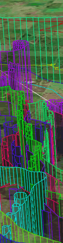
Second, the Sportavia International Open hang gliding competition is currently underway in Australia, and each day, The Oz Report adds the flight paths of competitors to this network link (KMZ). While we’ve seen Google Earth used for something similar before (the XAlps), the paths drawn by The Oz Report in Google Earth are a big improvement in terms of visualization, and very pretty to boot. (You can even fly along the paths of individual hang gliders. Instructions are here.)
Google Earth – Bongong Cup – Animation
In meinem letzten Bericht √∫ber die Bongong Cup Tracks in Google Earth hatte ich bereits orakelt das es nur noch eine Frage der Zeit sein wird bis die Tracks animiert √∫ber unsere Bildschirme flackern.
Keine 3 Tage sp√ßter pr√ßsentieren die Jungs vom …