Microsoft Virtual Earth has just had a major overhaul, as per this press release. Virtual Earth/Live Maps blog has a much more informative blog post on the changes, the most relevant of which for this blog are:
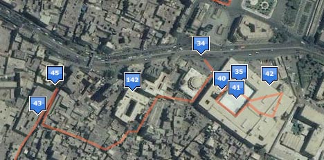
Importing of GeoRSS and GPX and…. KML! KML placemarks and polygons (such as the KML file of my walks through Cairo) work wondefully for most (though not all) files I tried and can be viewed in Virtual Earth via a simple URL structure (see the link above).
Network links don’t work in the current version of Virtual Earth. Still, the presentation of placemarks is well done, both as popups and in the left-hand column.

One thing that is missing is the wider context that a KML file might have — for example, the folder structure of a KML file is not represented in the left-hand column when viewed in Virtual Earth.
As an aside, in June at ISDE5 in a public forum I asked Microsoft if they would support KML in the future and Google if they would support GeoRSS in Google Earth in the future. Microsoft was non-committal in its answer, but today delivered. Google said it would definitely support GeoRSS, but hasn’t yet done so, despite what I imagine is a relatively simple tweak.
Bird’s eye view in 3D. This looks amazing, but I’m travelling with a Mac so I must experience it vicariously, as 3D in Virtual Earth is Windows-only. With hindsight, the obvious answer to the question “What do we do with PhotoSynth?” is “Use it on bird’s eye view images.” James Fee loves it too, and points to this video:
3D tours. Google Earth’s touring abilities have always been somewhat rudimentary — you can’t customize the tour for individual items, nor can you really control it as a user. Microsoft’s turned that into an opportunity to make tours a lot more usable. Again, I can’t experience it myself, but here is a video teaser:
You can even record video of your tour inside the browser! You need Google Earth Pro ($400) to do that natively.
3D modelling: Just like how Google Earth lets you import Collada-based models exported as KMZ files (usually made with SketchUp), Microsoft now lets you import 3D models using Dassault’s 3DVIA technology. Their partnership was announced in June, and has now borne this. Virtual Earth Blog describes it thus:
We partnered with Dassault to create a new application to allow anyone to create 3D imagebuildings and other objects in Virtual Earth. 3DVIA Technology preview allows you to create textured buildings and save them directly into your map Collections. This technology preview is the first 3D modeling offering between Dassault and Microsoft. We’re looking forward to community feedback from this release to help shape 3DVIA as it moves from technology preview to a first official release. […] Through our partnership we’ve created a new consumer tool that seamlessly integrates with Live Search Maps Collections. To try it out, switch into 3D in Firefox or IE on windows, right click and choose ‘Add a 3D Model. You can share your Collections that contain models just like any other and later this year we’ll release an update to our javascript map control that will let you integrate your models into web mashups! Much more on this feature area here on the VE blog over the coming days.
I do hope the 3D plugin for the Mac is coming soon, because publishing all this just to Windows does not a universal geobrowser make.
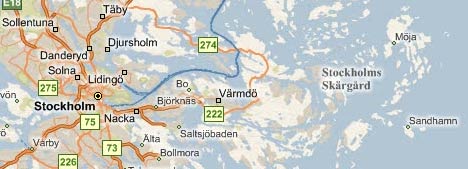
Better search: Ultimately, however, it is all about geosearch. How do Google Maps/Earth and Virtual Earth stack up in terms of content and usability? I decided to go looking for my favorite island, Sandhamn, in the Stockholm Archipelago.
Google Maps lets me “Search the Map” as a default, and I get to enter my search term into one text field and press enter. Typing “Sandhamn” in Google Maps returns four options, and I am asked to pick the right one. The island I am looking for is among the options.
In Virtual Earth, I am now also asked to enter text into one search field, instead of the two it had previously (and which was regarded by those who worry professionally about these things as a usability no-no). But the default search database is for businesses, as I discovered after going too quickly and getting no results.

Perhaps Microsoft figures that most users are looking for businesses when they do a geosearch — I usually don’t but my geo-search habits are probably not mainstream. Still, a default that searches for businesses only seems to me to limit the results unnecessarily. I’d prefer to see top results for all categories instead, or have some smart algorithm guess my intentions — for example, if there are no businesses named Sandhamn, perhaps there is a place with that name?
Changing the search database to Locations and then searching for “Sandhamn” in Virtual Earth returns one location in Southern Sweden. Unfortunately, it’s not the island I am looking for. Might it be listed under “Collections”? No. But if you scroll up the coast of Sweden, and look to the right of Stockholm to the edge of the archipelago, Sandhamn is nevertheless clearly marked. It’s just that search won’t help you find it:
In this example, Microsoft still needs to do some work to sync its maps with its database. I’d also prefer an even simpler search window, one that eliminates that extra click for non-business searches.
Of course, the above is not a representative sample, but rather one anecdotal case. Your results may differ. Still, people tend to choose their default mapping tool based on a few such cumulative experiences.
(Yet another rant: No I can’t run Virtual Earth on my Mac in 3D mode because Parallels doesn’t yet support the 3D technology the plugin for Windows needs. And No I can’t run Virtual Earth in Boot Camp because I have the latest MacBook Pro, and Apple hasn’t yet written Windows drivers for its graphics card, no doubt because OS X 10.5 has been delayed. I’m blaming the iPhone for this:-)
MS’s lack of search flexibility is primarily why I don’t use it. And as a result, I’ll refuse to use maps in Live/VE for that primary reason — especially in the context of embedding into a Web page.
I was looking more closely at VE 3D for the last couple months — mainly because I’m having issues with GE performance. I was liking where the plug-in was headed, but again — I run directly up against the brick-wall of usability because it’s not cross-platform. It remains, in essence — non-feasible for WWW use.
Mobile’s a slightly different picture — primarily because any device could realistically provide support within its native browser for the plug-in. But again, I mow over the search issues…
Once again, open shillery never ceases to amaze.:
http://www.fool.com/investing/general/2007/10/16/foolish-forecast-ogle-google-the-advertising-mogul.aspx
I like this new feauture
How did you create your KMZ file of your trip to Cairo?