[March 9: Read the follow-up article, Three trajectory models of the Chelyabinsk meteoroid compared]
[April 5: Help scientists to more accurately calculate the trajectory. Visit www.russianmeteor2013.org to contribute videos or help with the analysis.]
Two weeks on, Ogle Earth’s Chelyabinsk meteoroid story has led a interesting life. In the first hours after it went live in the early hours CET of Feb 16, it was first tweeted by Bad Astronomy’s Phil Plait and then more broadly by the astronomically minded community. After a day, the wider tech and science crowd found it. Two days later, mainstream media discovered it. A week later, it saw a second wind as a meta-story about citizen science. It’s received a respectable 100,000 visits so far, not quite making it Ogle Earth’s most popular story ever (that honor still goes to Finding Osama Bin Laden’s Abbottabad mansion with Google Earth from May 2, 2011).
However, it is by far the most commented story in the blog’s history, with around 340 comments to date, many making real contributions improving on the initial approximations. Thanks especially to early work by Sean Mac, SebastienP, Robin Whittle, liilliil and the other Russians who provided help with language and localization. If this article is an example of citizen science, it’s important not to overlook the collaboration that went on in the comments section. I was actually traveling in Africa for most of the past two weeks, not able to do more than moderating the comments passively.
I now know of four scientific teams that are in the process of homing in on a more precise trajectory for the meteor, some of whom have gotten in touch with me and who are now in touch with each other:
- There is a team at the Physics Institute of the Universidad de Antioquia in Colombia doing a more rigorous application of the idea of calculating from YouTube videos and Google Earth, posting initial results to ArXiv.org and using the trajectory to reconstruct the meteoroid’s orbit, placing it in the Apollo class of Earth-crossing asteroids. (Thanks, Jorge and Ignacio, for the reference to Ogle Earth in your paper.)
- There is also a team at the Astronomical Institute of the Academy of Sciences in Ondrejov, Czech Republic, that used the same or similar viral videos and Google Maps to calculate a trajectory for the meteoroid. Their results were posted as an Astronomical Telegram by the International Astronomical Union. They give a set of 6 position fixes so I’ve visualized these data points in this KMZ file for Google Earth.
- A team at the Cooperative Institute for Research in the Atmosphere (CIRA) at Colorado State University is calculating the trajectory from a totally different perspective — from space, using the vantage point of two different weather satellites. It will be interesting to see how closely their results correspond to those from the ground.
- And finally, on March 1 NASA released its own calculations, based on “U.S. Government sensors” that for the moment shall apparently remain nameless.
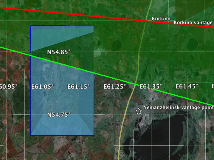
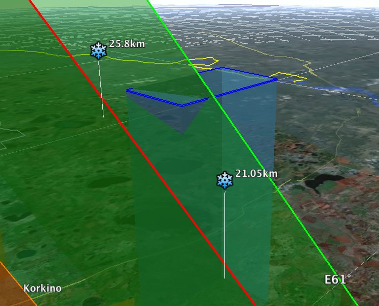
NASA’s data fixes a position for when the meteoroid reached its maximum brightness, given as “54.8°N, 61.1°E” at a height of “23.3 km”. These figures are given to three significant digits, or to the first decimal place; I don’t know if these are at the limits of the instrumentation used or artificially downgraded measurements, but assuming that these are natural bounds for error, I visualized this location in Google Earth as a rectangle at a height of 23,300 meters, delimiting the area between 54.75°-54.85°N and 61.05°-61.15°E. You can download the resulting KMZ file for Google Earth and use it together with the two (one and two) existing KMZ files from the original article.
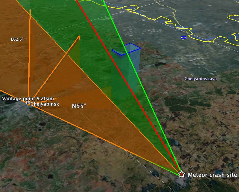
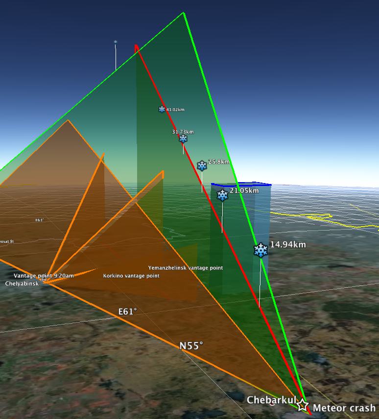
As you can see from the resulting interaction with the original KMZ files, NASA’s calculated rectangle neatly intersects with the calculated inclined plane along which the meteoroid was observed from Revolution Square in Chelyabinsk. The red line was my most likely trajectory, with the green line as an upper bound. That is a good match indeed! If anything, I think NASA’s results could be nudged a little northwards, considering how the very accurately geopositioned video from Yemanzhelinsk resolutely places the trajectory slightly north of the zenith there.
If you add the Czech results (linked to above), you find a ground path that is practically identical to the red line (they have the same azimuth) but with an angle of attack that is shallower than the one I calculated from the vantage point in Revolution Square. As a result, their trajectory appears at first blush to overshoot the main (or a major) crash site at lake Chebarkul, though of course it is also plausible that meteoroids at the end slow down and start falling to Earth. The shallower trajectory does place their path further away from NASA’s calculated rectangular “window”.
I’ll continue to update this post with improved scientific results as they arrive. Stay tuned!
[March 9: Read the follow-up article, Three trajectory models of the Chelyabinsk meteoroid compared]
[April 5: Help scientists to more accurately calculate the trajectory. Visit www.russianmeteor2013.org to contribute videos or help with the analysis.]
Impressive!
Take a look at this video of Shuttle Columbia as it breaks up during re-entry:
http://www.youtube.com/watch?v=lNfEUkxmliQ
You can see smaller pieces slowing down in relation to the larger ones. These smaller pieces slowed down enough to change their trajectory to a parabola, more in tune with projectile ballistics. This too could have happened to the piece that struck the lake,
This video appears to show that this happened with this meteor, too.
http://www.youtube.com/watch?feature=player_embedded&v=ZzwB7FeJRgA
The fragments appear to be doing their ballistic thing. Why they are off to the left (south) is a mystery to me, though.
The security camera is at 54°50’56.53″N 61°33’15.14″E, just NW of Yetluk/Etluc/Etluk. I’ve matched the GE image with the objects in the foreground and in the distance.
Steve Garcia
Those are likely not fragments but reflections in some kind of security glass of this well-protected base, as determined in comments to the previous post.
I agree too. But it is sure that the bolide broke into several pieces. One of them must have sunk in Chebarkul’s lake. But if NASA is right, the main piece landed some 30km farther to the west and 2 to the north (near Nizh.Atlyan,RU @ 54.9910888888889N 59.8733472222222E ). I used for this the only other information given by NASA here:
http://neo.jpl.nasa.gov/images/Chelya_track_annotated_s.jpg
and reconstructed it on a scale model of the Earth (based on WGS84). I need to redo it more accurately before beeing able to share it.
The path given by NASA with 3 points (100km / 500km /1000km) crosses also the square around 54.75°-54.85°N and 61.05°-61.15°E
The Yetluk Pumping Station video is very poor.
Someone is holding a video camera, unsteadily, and recording off a screen at quite an angle.
The lines at the top and right hand side are no where near straight or at right angles.
The meteor also appears near the edge of the field of view of the security camera, so the geometric distortion of its lense would be significant.
You also have the additional geometric distortion of the second camera lense.
Even if you could digitally model all the geometric distortions you still have the problem of not knowing if the aspect ratio is correctly displayed.
If the horizontal and vertical image scale ratio is not maintained all the way from the CCD chip to the display screen, angles will be displayed incorrectly.
In this case, you have twice the chance of aspect ratio distortion.
The first 6 seconds or so are from after the meteor, see the smoke trail top right.
In the first place, you’d have to get the field of view for that camera. This appears to be difficult as the poster doesn’t want publicity.
Carefully using this map from NASA, I did again the calculation of the path. Sadly, I don’t know how to create an oblique line in Google Earth. So I give you the coordonates. It scratches the square for the explosion that NASA located at 23.3km height.
@100km altitude: -54.3833, +64.9512
@Ground (theory): -59.8603, +54.9735
The theoritical point of landing is farther than Chebarkul. And not inline. But strewn fields are always elliptical.
Thanks SebastienP, I’ve been collecting and modeling trajectories and will add the NASA one from your values. I’ll publish the results in a new post soon.
Hi Stefan, I mistakenly inverted some signs/long/lat. It should read as follows:
@100km altitude: +54.3833, +64.9512
@Ground (theory): +54.9735, +59.8603
Help scientists to more accurately calculate the trajectory. Visit http://www.russianmeteor2013.org/ to contribute videos or help with the analysis.