Last Thursday, on the way down from an arduous walk into Socotra’s Haggier mountains, I chanced upon a circle of Socotran men in traditional garb at a wadi, picnicking with freshly roasted goat and tea. In English, they invited me to join them — they included Socotra’s six English teachers, one for each school on the island, celebrating the end of a two-week teaching workshop, in anticipation of teaching all Socotri children English from 4th grade starting next year (versus from 7th grade now).
Over handfuls of goat liver and rice, we discussed many things, but eventually the conversation turned to why I had come to Socotra. I mentioned Google Earth, expecting to explain it — but they all nodded immediately. How did they know Google Earth, I wondered? It’s on the computer at the main school in Hadiboh, Socotra’s capital. The other schools in Socotra remote villages don’t have internet access, but Google Earth is part of the curriculum in Hadiboh.
As for Hadiboh’s only internet café, where tourists and locals vie for the three PCs sharing a single 512Kb DSL line — Google Earth was installed on all of them.
I went to Socotra to get away from technology:-) but came back more aware than ever that the internet, and the applications it makes possible such as Google Earth, truly are the globe’s great levellers. The world is flat, and getting flatter.
Before starting on some meatier posts, here are some links from the past week or so:
- Topo KML Python script: Mitch Harris writes:
After using the 3dsolar topo overlay maker for a while and becoming frustrated with its shortcomings I decided to do something about it. I made a handy python script which will make a topo overlay for the specified area and save it as a KMZ. It’s still early in development but works quite well. The advantage here is that you can pan and zoom in GE without it reloading all the time and also have the topo overlays available offline. Feedback is appreciated.
- Serving browser-dependent KML: Stephanie Lange discovers that KML in Google Earth 5 is rendered differently in some case than in version 4 (not to mention compared to Virtual Earth, Google Maps and Earth Browser). Reminded of how different web browsers render HTML differently, she’s set about developing a way to deliver different KML to different Earth browsers, documenting her process. An interesting read.
- OS X 10.6 to be location aware? Says AppleInsider:
People familiar with the latest pre-release distributions of the next-gen OS say the software now includes the CoreLocation framework previously available via the iPhone SDK, which will allow Mac applications to identify the current latitude and longitude of the Macs on which they’re running.
(Thanks Michael Smalley)
- Historical Street View? Michael Smalley has an idea: Preserving Google Street View layers in a historical database, so that panoramas taken from before the recent forest fires in Australia can serve as a record in perpetuity of what the destroyed communities there once looked like. Now that Google Earth has such historical databases for its satellite and aerial imagery, giving street view the same treatment is certainly an idea worth pursuing.
- SketchUp & autism: Google SketchUp proves to be a popular application with kids with autism, reports Newsweek.
- Google eArt, cont: Fantastic:
2000 square meters of rooftops have been covered with photos of the eyes and faces of the women of Kibera [Kenya, one of the largest slums in Africa].
Not to worry, the covering is in sturdy plastic, so serves as new roofs as well. The art is intended to be visible to the satellites that eventually populate Google Earth. (Via Andrew Sullivan)
- Holocaust, mapped: The United States Holocaust Memorial Museum has two new KML layers detailing the geography of the holocaust — a timeline layer showing concentration camps across Europe, and a holocaust encyclopedia that highlights places prominent in the internment of Jews, homosexuals, Roma and other minorities. (Via Le Technoblog du LAC)
- Mars flight simulator: Fly an F16 on Google Mars, just in case you still haven’t tried this…
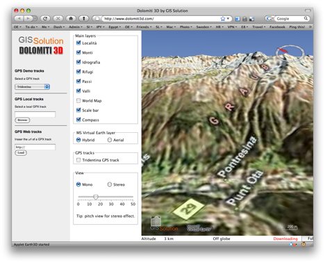
- Virtual Earth 3D on the Mac (sort of): It’s baffled me why Microsoft continues to have Virtual Earth 3D be a Windows-only experience when this is clearly an impediment to having developers create universal browser-based apps, regardless of operating system. Now a third-party developer, The imaginatively named GIS Solution has made Dolomiti 3D, a browser-based virtual globe Java applet focused on showing walking trails in a section of the Alps but which can show any GPX track and in fact the entire world — apparently using Microsoft Virtual Earth’s 3D dataset and DEM. And it works seamlessly on the Mac, using many of the same keyboard controls as Google Earth. (Thanks Jeffrey)
PS I lost my Nokia N95 somewhere in Yemen, and as that is the only phone I own that can phone in coordinates for the GMap-Track map on the top-right of this website, I’m removing the map for the time being, as an out-of-date map is worse than no map at all…
In regards the 3Dsolar “USGS Topo Maps” network linked overlay:
I use this all the time, and I too was frustrated by its wanting to refresh itself every time I moved.
To get around this small irritation, I first copied that one placemark out of the 3Dsolar collection to a spot near the top of my placemark list – so I could find it easily.
Here’s the important part: Open the placemark’s properties. Click the “Refresh” tab. Change “View-based Refresh” from “After camera stops” to “On Request”.
Now, any time I want a topo overlay of the area I’m viewing, I check this placemark and get an overlay. If I want a different area, I right-click the placemark and choose “Refresh”.
A note: If you’re too close to the ground, you’ll get a big red X instead of an overlay. Just move up into the air a bit and do another refresh. Eventually you’ll be at the lowest altitude that’ll let you get an overlay.
Another note: If you want more area covered, you can have multiple instances of this placemark. Just make sure that they have different “internal” names – you’ll probably want to edit a few .kml copies with a text editor.
I’ve found this to be an indispensable tool and hope 3Dsolar keeps supporting it. BTW, as far as I know, this tool only works in the U.S.
Ernie
Re: VE3D on the Mac
I’m pretty sure that the applet is based on WorldWind Java (the same compass and status bar:)
but it would mean that only the imagery comes from Microsoft and DEM is from NASA servers.
There is a thread on WWJ forums about ‘importing’ VE data to WWJ http://forum.worldwindcentral.com/showthread.php?t=20978 (not only VE – also Google, Yahoo! and OpenStreet Maps)