Have you downloaded and installed Google Earth 5? Good.
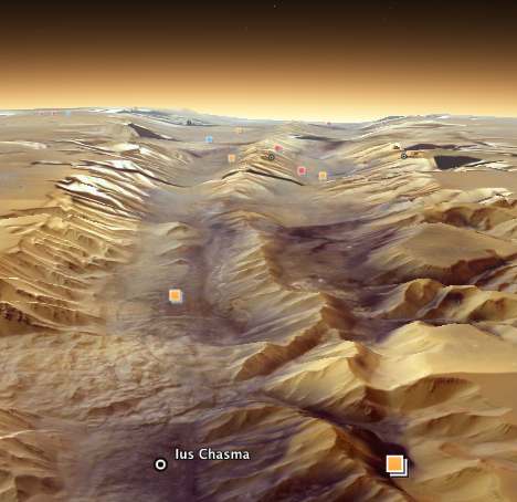
Before we start — Google Earth 5 comes with Google Mars! Click on the planet in the top toolbar and choose Mars. And once there, you get a whole new set of content to choose from, including some great new recent satellite imagery from HIRISE.
Here’s the content that’s available:

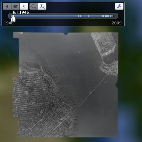
We’ll get to the oceans soon enough, but first, what is going to make by far the biggest difference to neogeosleuths is the fact that every single historical imagery update since the start of Keyhole Earth/Google Earth is now available, and also satellite and aerial imagery going all the way back to 1940, before the start of the space age. Here’s San Francisco in B&W from 1946:
Here it is in action, over the Fayyum, Egypt:
Google Earth 5: Historical datasets from Stefan Geens on Vimeo.
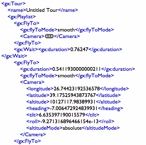
The other big new feature is recordable tours. Click on the video camera button in the top tool bar, and a recording button appears on the screen, together with a microphone. Click on the recording button to start recording your navigation in Google Earth, and if you click on the microphone you can add realtime audio commentary.
If you like the resulting tour, you can then save it into your Places control panel. What you’re saving is markup language, and it looks like this:
It’s important to know what this tour feature doesn and doesn’t record: It doesn’t record what overlays you have showing in Google Earth (or Mars or Sky) which popups you click nor if you are changing the historical background dataset. You can’t therefore use it all by itself to show specific content in Google Earth — you’ll need to tell the user what to turn on first. (I suppose you could use the audio track to tell him/her that.) The most likely use for this touring feature will be to include it in a larger KML file that you provide for people to download, with content that is visible by default.
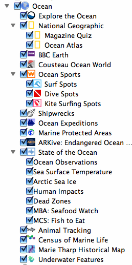
Now for the main (press) event for Google Earth 5: Oceans. From afar Google Earth looks just like the old globe, with a 2D relief view of the oceans. As you zoom in in closer, the oceans become covered with a smooth undulating “sea” layer that provides a more realistic view of the Earth. Then, when you duck under the surface of the sea, you get to see the real 3D bathymetric view of the surface of the Earth under the sea. In both cases — looking from below the ocean to land, and looking through the ocean layer to the ocean floor — you see a real 3D height mesh that extends both above and below sea level. The best way to see it in action is to toggle on/off the Terrain layer — though I do wish there were a way of turning off the undulating sea layer while keeping the 3D height mesh for both sea and land. [Update: There is! See comments.]
But Google Earth 5 doesn’t just have this great new technology. There is a huge amount of additional content made available by Google in a new Oceans default layer. There is too much there for anything more than a cursory look just now, so here’s the whole list, just for the record:
Another big new feature is that — as promised — Google Earth 5 contains the discontinued Google Earth Plus‘s features, free, such as the importing of GPS tracks and real-time tracking. The ruler feature now also gives you the heading of a line you draw (and, yes, it will undulate over the terrain, including over underwater features.)
Some of the other new (or recent) changes:
- Tracks4Africa has been re-promoted to the Gallery — or rather, an expanded collection of placemarks by Tracks4Africa are now in the Gallery, while the road tracks are still in the “More” default folder. This is the only new addition to the Gallery and Global Awareness default folders, but that’s understandable, as the focus with this release is resolutely on the oceans.
- The Mac version looks at lot more Mac-like. Buttons get a refresh, and the overall feel is sunnier.
- the “More” default folder now also contains 2009 DigitalGlobe coverage.
- 3D buildings now has two subdivisions — Photorealistic and Gray — letting you choose precisely how bandwidth-hungry your Google Earth will be. [Update: Apparently this is an older feature]
- Switching to Mars, turning on an satellite image overlay and then switching back to Earth will continue show the downloaded Mars overlay,but on top of Earth — just like with Google Sky in Google Earth 4.3. Since the Places layer is shared by all datasets (Earth/Sky/Mars), you can however easily turn it off there.
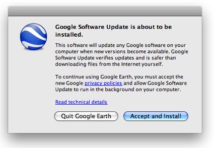
- On the Mac version, You have to agree to the installation of an updater that runs in the background. (There was some criticism about this not being made explicit when downloading the Google Earth plugin for Mac browsers.)
- The Preferences pane has some new features:
- 3DConnexion’s SpaceNavigator works out of the box for above-ground work, but still thinks that there is nothing below the ocean surface. To navigate properly below the surface, you’ll need to avail yourself of the keyboard- or screen controls.
- And, yes, the islands that went missing a few weeks ago are still missing:-)
Now that all that is out of the way, pardon me while I go and play. I don’t really know where to start, but that’s a problem I love to have.
About “3D buildings now has two subdivisions — Photorealistic and Gray”, this option was before in GE4, it’s not a GE5 new option. I’m talking about Windows version, not sure if on Mac it was.
Umm, playing with the timeslider does get recorded in a Tour for me. (on windows). Adds a
<gx:TimeStamp><when>2005-06-26</when>
</gx:TimeStamp>
to the <Camera> inside, <gx:FlyTo>.
And opening closing balloon windows are recorded. But it seems only to ‘Places’, not to ‘Layers’
<gx:AnimatedUpdate>
<Update>
<targetHref></targetHref>
<Change><Placemark targetId=”mountainpin1″><gx:balloonVisibility>1</gx:balloonVisibility></Placemark></Change>
</Update>
</gx:AnimatedUpdate>
Oh and the 3D navigator works just find under the ocean for me? Again I’m on windows tho, and my graphics card is old, so dont get the animated sea, maybe that makes a differece?
Right you are Barry – however, I couldn’t get it to work earlier, and I still can’t get it to record the showing and unshowing of overlays that are in my Places, can you? Or perhaps this is a bug?
Yes balloons opening/closing, and enabling/disabling features seems to be recorded.
But during playback it sometimes doesnt seem to toggle if the thay arent in the same condition at the start. (eg I started with a layer on, and record it been switched off, and then on. During playback, if start with it off, it doesnt even turn on. )
My SpaceNavigator seems to be waterproof – that is, I have no trouble navigating below the sea surface with it. Alas, it still navigates with only 5DOF – no roll function.
You can remove the ocean surface by unchecking View > Water Surface from the menu.
Also of note for Mac users of version 4.3, we can once again see multiple images from local KMZ files. So if you happen to have used your favourite KMZ maker and were only seeing the first embedded image you clicked on, I’d recommend the update (plus there’s all that Mars/Ocean/Tour stuff too)
A couple of notes:
* If you make sure to have the placemarks you want to use in the folder with your recorded tour, then you can deliver a tour with recorded placemarks that work.
* SpaceNavigator works fine for me under the ocean. However, I’ve seen various reports from others about issues. Not sure what the difference is. I’ve suggested making sure your applications settings are right in the 3DConnexion preference panel.
SpaceNavigator working or not working under the sea seems to depend on the Earth-based/User-based setting in Google Earth (Tools-Options-Navigation on Windows version).
User-based works for me, Earth-based doesn’t.
Thanks GOD for giving you the Divine wisdom to discover this wonderful innovations of Google earth 5 but I can’t record the tour. Thanks and praying for your efforts. GOD BLESS
When will Google Earth API Plug in for version 5 available.
Please look at my sites http://www.4dcity.com
it’s all GE stuffs
Prateep
Why didn’t have traditional chinese traslation for people? Thanks!
Why do some heights on Google Mars have negative values?