[Update 24 Feb: It turns out that there was no censorship by Google after all. Please read this follow-up post for the reasons why.]
On February 12, 2009, Chairwoman of the US Senate Intelligence Committee Senator Dianne Feinstein said at a hearing, perhaps unwittingly, that the CIA’s unmanned MQ-1 Predator drones used to hunt Taleban and Al Qaeda cells on the Pakistan/Afghanistan border were deployed from a base in Pakistan. (Pakistan quickly denied Feinstein’s account, the Wall Street Journal would later report, but both papers got off-the-record confirmations of the accuracy of Feinstein’s statement from senior intelligence sources.)
On February 17, The Times of London ran a story alleging that the US was flying MQ-1 Predator drones out of Shamsi airbase in Pakistan’s southwestern province of Baluchistan. Exhibit A in its investigation was the delivery of a special kind of fuel to the base, as revealed by the website of the Pentagon’s fuel procurement agency. There was no mention of satellite imagery in the article.
On February 18, Pakistan’s The News reported it has seen satellite imagery from 2006 showing what is most likely three US Predator drones deployed at a remote air strip in southwest Pakistan. It also reported that the imagery was still available in Google Earth (though the web version of the story does not make any imagery available).
Such revelations are an embarrassment to the Pakistani government. The drones — used to hunt down Taleban and Al Qaeda cells on the Pakistan/Afghanistan border — are unpopular with Pakistanis, and the Pakistani government has repeatedly said it does not allow the US to base the drones on its soil. The US has likewise denied it has operated drones out of Pakistan, Feinstein notwithstanding. The imagery from 2006 contradicts these denials.
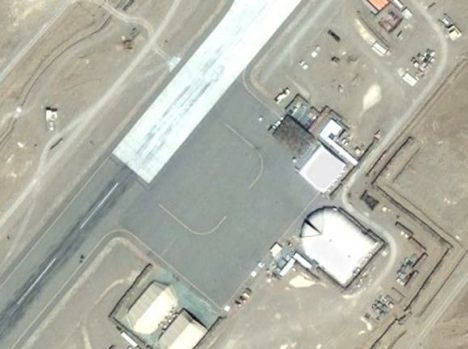
On February 19, The Times of London ran a follow-up article that made the 2006 satellite image available — it clearly shows three drones deployed at the airbase, with dimensions that fit that of the Predator. It also reported that the imagery was no longer available on Google Earth.

Click for full-resolution version
That image, when compared to the current DigitalGlobe image available in Google Earth taken on March 30, 2007, clearly shows the same airbase (Google Earth placemark), though with some significant new construction:
The Times makes the same DigitalGlobe image available, annotated:
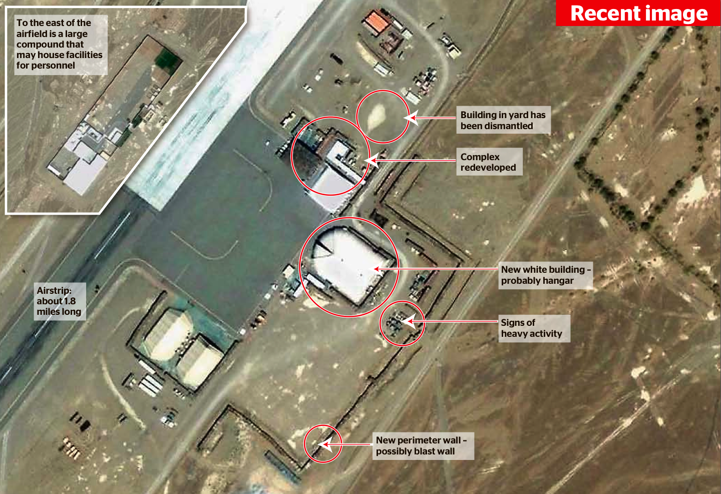
Click for full-resolution version
Note that the Times’s image does not carry the Google Earth logo, and has a higher contrast that the Google Earth version. Without being conclusive, this suggests the Times’s source for the imagery is not Google Earth, but perhaps a direct purchase from DigitalGlobe’s online store, which has the same imagery available as that visible in Google Earth.
That’s how far the mainstream media took the story. What have the bloggers had to say about it, especially regarding the apparent act of censorship in Google Earth around Feb 18?
On Google Earth Community, spotter2 makes a good case that the imagery from 2007, while not showing drones, does show evidence of continued drone deployment, based on the shapes and sizes of the specialized shipping containers used to transport predator drones.
Over at IMINT & Analysis, Sean O’Connor notes that the new construction between the imagery from 2006 and 2007 suggests that the base is intended for longer term use:
The US government’s claim that the facility is no longer used may or may not be accurate, either: the large hangar visible at the bottom of the image is a new addition since 2006, and the two clamshell-style tent structures to the left of the image are common US military structures found at various operating locations throughout the Middle Eastern theater of operations.
When it comes to the question of censorship in Google Earth, however, the smoking gun is to be found on the Pakistani blog Teeth Maestro, which has posted a screen capture from Google Earth, proving that the application did indeed once show the 2006 imagery with drones:
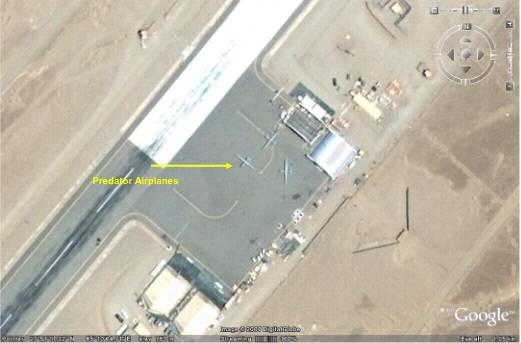
Click for original-resolution version
So what happened? Where did this imagery go?
[Update 24 Feb: It turns out that there was no censorship by Google after all. Please read this follow-up post to find out how that’s possible.]
Until the release of Google Earth 5, it would have been hard to confirm such a case of intentional censorship by Google — older DigitalGlobe imagery in Google Earth periodically gets replaced by newer imagery, and thus 2006 imagery would eventually be replaced by 2007 imagery. Only the timing would be suspect.
But with Google Earth 5, we now have access to a historical archive of DigitalGlobe imagery from the past several years, using the historical imagery time slider. Older imagery should still be visible in Google Earth, but in the case of the region around Shamsi airbase, there is no record of high resolution imagery taken sometime in 2006:
And yet we have a screenshot of such imagery once having been available in Google Earth.
I went looking for this imagery in DigitalGlobe’s online store. The one previous time that there was a clearly documented case of Google Earth removing imagery at the request of a government (Basra, Iraq, in 2007) the imagery remained visible in the DigitalGlobe’s archives. No such luck this time, however. The DigitalGlobe ImageFinder service betrays no trace of any imagery taken by DigitalGlobe’s satellites of the airbase in 2006:
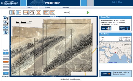
(The two references to 2006 are for imagery that does not cover the base.)
We can therefore conclude that the satellite imagery from 2006 showing drones has not only been removed from Google Earth, but also from the source of Google Earth’s imagery in this part of the world, DigitalGlobe.
The sad but inevitable conclusion is that we have here another clear case of documented censorship in Google Earth — though it remains a mystery by what mechanism this censorship occurred: Did both Google and DigitalGlobe separately receive a request from a government (presumably the US, but possibly Pakistan) to remove this imagery from public scrutiny, and comply, or is there a contractual obligation/legal obligation on the part of Google to remove imagery from Google Earth if DigitalGlobe removes it from its product list? Did DigitalGlobe make a mistake in publishing the 2006 imagery available in the first place, considering that the US military has “shutter control” of the satellite’s cameras? Or perhaps (and I’m merely speculating), since the Predator drone operations are run by the CIA and not the US military, were shutter control orders somehow not properly relayed via the usual channels?
None of this changes the fact that removing imagery which has already been scrutinized by the media is an extraordinarily pointless act. I hope this implies that Google’s removal of the image was the result of legal or contractual coercion, rather than voluntary compliance with a non-binding request.
Thanks for making public this issue, it’s a very rare chance for people to actually see the government attempting to re-write history.
I’ve just put another placemark on Gooogle earth, and I’ve included a link to this site, let’s hope the word gets out about this censorship.
could also be Global Hawks