Slowly but surely, operating systems are getting geosavvier, but if it isn’t happening fast enough for you, there are some tools to help you out. CDFinder, a $39 professional strength (as in “newsroom media library”) file cataloguing tool for the Mac, has had the ability to search for geotagged photos by coordinates since early 2008 (when it was blogged on Ogle Earth). Now CDFinder 5.5 has just been released, and it does a lot more in the geo-department. CDFinder’s developer Norbert M. Doerner writes:
I have now released CDFinder 5.5. Here is a list of the GPS related new features:
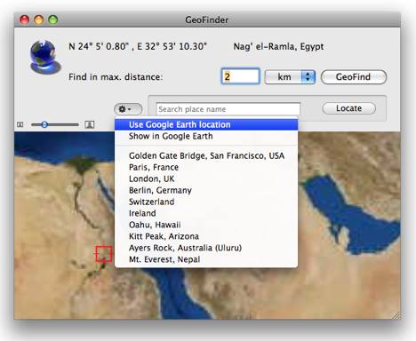
- The new GeoFinder dramatically improves the Geo-Search feature: A fully interactive map allows you to specify the starting point for your search, and you can use the current Google Earth position, along with preset locations and a new place search
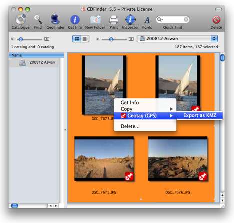
- CDFinder can now export geotags into the KMZ format, including previews of the actual photos and important metadata, such as the location and camera parameters. That does of course work for any photo format
- All photos with GPS data now have the GeoIcon badged to their thumbnail in the CDFinder windows
- CDFinder can upload your geotagged photos to www.locr.com! Simply context click on any photo with a GeoTag, and use the context menu to start the upload dialog
- When cataloging GPS data, CDFinder now also reads the azimuth, tilt, and distance values written by Graphic Converter and some GPS modules attached to Nikon cameras. This value is then used for “Reveal in Google Earth”, as well as the KMZ export file
- The GPS location data of a photo can now copied to the clipboard, using the context menu
- Added SmugMug, WikiMapia, Yahoo Maps, Geoudy, OpenStreetMap, and Woohpy to the GPS menu
I am very happy that Apple has finally seen the light about getagging as well, that means that the whole thing is moving towards mainstream, that can only be positive…
Here is a screenshot of CDFinder’s GeoFinder in action:
Of course, this kind of search becomes useful once you have a lot of georeferenced photos. Here’s how the “Export as KMZ” function works for a group of selected photos:
I gave it a go with some recently georeferenced photos. The resulting KML is basic but functional and works fine as way of quickly getting the photos on a map. (I saved the KMZ file to my Dropbox public folder, and made a network link to it and also saved that to the DropBox folder. Here it is as KML and here it is as a Google Map.)
If exporting photos to KML files is your main aim, you should also take a look at the recently updated $30 Mac geocoding app HoudahGeo 2, which offers the same export ability. It has more options upon export, though the resulting file is also quite basic.
CDFInder and HoudahGeo are different and complementary beasts, however: HoudahGeo does geocoding, reverse geocoding and exports to Flickr; CDFinder helps you navigate your metadata. Since both HoudahGeo and CDFinder come as free demos, do try them both.
Meanwhile, I’m still looking for a good style editor for KML. Or even a bad one:-)