When I was a kid my cousins and I would spend summers at a farm in the Belgian Ardennes, where we’d get very creative at getting up to no good. We’d go exploring all over the place, and sometimes, mostly where fields become forests, we’d find old expended bullets or even, on one occasion, a partial helmet. We would bring them home and then my father would explain about World War II, and how the fields around us saw some fierce and desperate fighting in the winter of 1944-45, during the Battle of the Bulge.
That was around 1977, when I was 8 and the war was “only” 32 years past. We’re exactly twice as far removed today, in terms of time, from the end of World War II, which is a strange and sobering thought, because those fields today look exactly the same as they did when I was a child. But they certainly wouldn’t have in 1945.
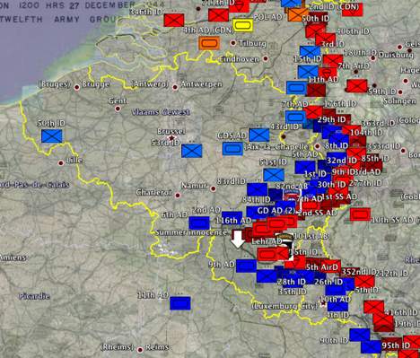
All this I remembered when a few weeks ago Free Geography Tools made me aware of a web page that has recreations of famous historical battles available for download as KML files, complete with time-line progressions. The files are the final projects by US Naval Academy students in SO432, Datums, Map Projections, and MGRS Lab.
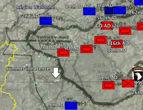
When I looked at the recreation of the Battle of the Bulge (a whopping 94MB KMZ file containing a series of digitized map overlays in Google Earth), I suddenly realized that my father hadn’t been talking in the abstract when he mentioned the fields around us. He meant it literally. On December 27-28, 1944, the Nazi incursion into Belgium reached its furthest point. The tide was turned, I now realize, precisely in those fields and woods where my cousins and I played so innocently in in the summers of the 70s, marked here by the white arrow:
That sure brings home the Battle of the Bulge for me. And thanks, by the way, if you were there.
Thanks for posting this Stefan. I had missed the original FreeGeographyTools post. When I was young, I spent many days poring over this kind of map, and it is good to see people bringing it into modern visualizations.