Scientists have been watching Antarctica’s Wilkins Ice Shelf carefully these past few years, as it has been getting smaller and smaller. Back in March 2008 its impending disintegration made for some great aerial video as well as a satellite image overlay of the ice shelf then.
Now, the death watch has begun in earnest. In Late November 2008, reports the European Space Agency,
[…] new rifts developed on the ice shelf that scientists warn could lead to the opening of the ice bridge that connects the ice shelf to the Charcot island. If the ice bridge were to open, it could put the entire ice shelf at risk of further disintegrating.
As a result, ESA scientists have begun posting satellite imagery of the ice shelf to the web on a daily basis, using imagery from ESA’s Envisat satellite’s Advanced Synthetic Aperture Radar (ASAR).
The archive of daily imagery is available here, or you can watch an automatically updated animated GIF of the most recent images:

Google Earth doesn’t support animated GIFs, but I did take a recent still image and turned it into an overlay of how the ice shelf looks now:
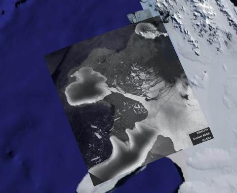
Combine it with the overlay from March to see how things have changed since then.
Nice post. If you had the time for each image, you could put each frame in a GroundOverlay with a TimeSpan to animate the ice shelf collapse.