- Australia, Japan get Street View: Amazing — Australia is now smothered in blue Street View lines in Google Maps — including some of the most out-of-the-way places you can imagine:
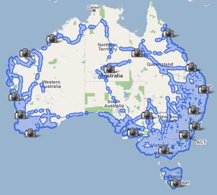
The Australian‘s take: “Privacy advocates say Google’s gone too far,” though not, it turns out, Australia’s Office of the Federal Privacy Commissioner, which thinks Google’s approach is fair dinkum enough. Japan too gets some of its main cities covered. Thanks to Claudia Carvalho for the tip.
- Olym-pics not for the Chinese: Google’s recently updated satellite imagery of the brand-new Olympic stadiums in Beijing — which would provide ample opportunity for the Chinese to feel proud — is alas not available to ordinary Chinese, as inside the Great Chinese Firewall Google’s Chinese-language Ditu Maps service does not have a satellite imagery layer at all. Because, you know, all those domestic terrorists would never dream of using a proxy server to maps.google.com.
- OneGeology outputs to KML: It turns out that OneGeology, previously flagged on Ogle Earth but not tested due to browser limitations, outputs to KML, as Hypocentre points out Now that I’ve had access to IE7 for a bit, I can confirm that the exported view-based network link works great in Google Earth. All Points Blog also lauds the data, but comments that the site’s technical underpinnings is a bit dated. As far as I’m concerned, the KML links for the regional layers serve all my needs — it would be great to offer them as a list of links on a plain-vanilla web page that don’t depend on a small subset of browsers or the map view — I know where Africa is:-) Oh and a KML layer with the key would make it perfect.
- 3DXplorer – new Java-based virtual world: Serendipitously, just a few days after Avi Bar-Zeev clarifies the difference between two different kind of “browser-based” 3D virtual worlds/globes (one kind requires a plugin be installed, the other relies on the browser’s own resources — which is a much harder feat to pull off) an avatar-driven virtual world of the second kind is announced: 3DXplorer. Tantalizingly, it supports COLLADA models of the kind made by SketchUp and found in Google 3D Warehouse. In other words, you can create your own virtual worlds on your own website, populate it with existing 3D content, and let anyone with a free 3DXplorer account visit. That could well be a winning formula, with a free hosting option for low-traffic sites and paid options that are competitive with Second Life, depending on usage patterns. It runs in java 1.6, which alas Apple has been tardy shipping as a default with OS X (it’s still at 1.5). The main constraint, I suspect: It doesn’t look as slick as Second Life.
- Mapufacture + GeoCommons: Geoweb pioneer Mapufacture, with its early support for syndicated georeferenced content via GeoRSS, is being acquired by FortiusOne, which is democratizing access to complex GIS databases via its GeoCommons platform. As Mapufacture’s Mikel Maron, Andrew Turner and FortiusOne’s Sean Gorman explain it, the two services are complementary and hence a perfect fit — Sean Gorman:
The long term vision has been to eventually fuse the personal and dynamic data of the GeoWeb (long tail) [Mapufacture] with the static and statistical data of GIS (short tail) [Geocommons].
I think it’s wonderful that there is consolidation afoot among the social geoentrepreneurs — there are some very big fish in the geospatial pond.
- Earthmine update: O’Reilly Radar updates us on progress with Earthmine, which is working on an API to integrate its “Street View on steroids” into third party web sites. Don’t know about Earthmine yet? You need to check out this video.
- Landsat to go free: Announced today: 35 years of archived Landsat imagery will be made freely available on the web by the end of 2008. The U.S. Geological Survey will be hosting the data, which is good news — the USGS is an enthusiastic adopter of KML for many of its other projects. Depending on how comprehensively this dataset is integrated with Google Earth et. al., we’ll soon be able to browse the Earth in time as well as in space.
4 thoughts on “Links: Street View downunder; no Olympic satellite view for China”
Comments are closed.
i will like vic photo thank you
What’s amazed me is the extent of the coverage. Some real out of the way places.
Thanks for mentioning 3DXplorer V4.
In the interest of full disclosure, I am the VP of Marketing for Altadyn, the developers of 3DXplorer, but I will try to keep my comment purely objective. ;-)
Regarding the comment about Mac support for Java 1.6, we recently added support for Java 1.5 so Mac users should be able to visit 3DXplorer worlds without the need to upgrade.
Try these links to enter these Java 1.5 compatible worlds, with any Mac, or PC running Windows or Linux, with Java 1.5:
http://www.3dxplorer.com/download_file/worlds/index_benaroyagrandlobby5.html
http://www.3dxplorer.com/download_file/worlds/index_benaentrywaygateslob5.html
http://www.3dxplorer.com/download_file/worlds/index_founders5.html
http://www.3dxplorer.com/download_file/worlds/index_picasso5.html
Note, if one wants to design worlds with Java 1.5, use 3DXplorer V4.01.02 when using the 3DXplorer online interactive studio.
To use V4.01.02 in the 3DXplorer Studio, choose this version explicitly from the pull down list provided in the studio for editing and publishing. Any world thus created can be visited by all Java 1.5 users (Mac, PC, Linux) as well as Java 1.6 users. The avatar configurator does not yet support Java 1.5 but will do so shortly.
Note that I use the Java 1.x convention above, for instance, Java 1.5 or 1.6. These are the same as Java 5 or Java 6 respectively.
Also regarding the comment above: “The main constraint, I suspect: It doesn’t look as slick as Second Life.” Of course, that is a subjective call, but 3DXplorer uses OpenGL which delivers extremely high quality visuals. We’re not even using everything its capable of, so it is only going to get better, but check out the level of detail and quality in the worlds linked above and compare for yourself.
In addition, as mentioned above our strategy is to leverage user-generated content created in popular design and modeling software via support for industry standard formats like COLLADA and 3DS. As a result, the detail and quality of the 3D virtual worlds one can create in 3DX is on par with any “professional” content creation on the market. In other words, one can use SketchUp, 3ds Max, Softimage, Maya, Autodesk’s Revit, etc. to create 3D content that can then be imported, scaled, positioned, colored, re-textured, hyperlinked to other worlds, etc. in the 3DX studio. As with Second Life and firms like ProtonMedia and Millions of Us, one can use a professional designer or firm to create the entire world or a portion of their world. However, we also want to make it accessible to anyone so an individual can quickly create their own world themselves in a couple of hours or less. The level of detail and quality is completely user controlled.
For reference, the virtual Benaroya Hall linked above is a concert hall in Seattle that is home to the Seattle symphony. It was modeled in Autodesk’s Revit and looks pretty impressive.
-Greg
Fantastic views……….with amazing details