Magnetic bull

So somebody wrote a press release yesterday about Google Earth Magnetic Cows, but it sounded so silly that I decided to go for celebratory end-of-panorama-trip cocktails instead of dirtying my blog with it. Imagine my surprise to see it hit the interwebs with a vengeance today, but the greatest surprise of all was that only one blog so far, The Earth is Square, has reported this “news” skeptically. [I just noticed Google Earth Blog is also skeptical:-)]

The bottom line: It’s entirely possible that cows have a magnetic sense, but we’re not going to find out about it by looking at Google Earth. What possible fallacies might there be? I came up with these in, oh, a few seconds:

  • What cow? Have you ever seen a cow on Google Earth? Are you sure? Most of Google Earth’s imagery is not in high enough resolution to let you discern cow from car from tent from bear. And you certainly can’t tell which end is up, so to speak. In any case, your sample population of successfully found cows is bound to be miniscule compared to the total population.
  • Now cow? The imagery in Google Earth is exclusively taken on cloudless days — or we wouldn’t have had the imagery. Are we sure the cows weren’t using the sun to align themselves, say to maximize solar exposure in winter and minimize it in summer? As the best satellite photos are taken when shadows are at a minimum, i.e. noon, that alone would lead to aligned cows.
  • Stupid cow: Cows are walking stomachs. If they hit a fence while grazing, they will move along it. At most, this study tells us that fences have a slight preponderance to point North-South — and fences are even harder to see on Google Earth than cows.

So what happened? Either this story is an elaborate hoax, or it isn’t and these scientists are just not very good, or the story has been reported inaccurately. It’s a cow toss as to which of these explanations is the right one, but I suspect hoax, in part because of the study’s claim that it could discern a predispostition in cows for magnetic north over true north — a difference that is miniscule in most places on Earth. It doesn’t help that you have to pay the US National Academy of Sciences $10 to read the paper — that’s the price of a cocktail here in Stockholm, one which I’m about to go buy.
Links: Ogle Sweden redux, Jailbird’s eye view, Microsoft Surface in the wild

  • Ogle Sweden update: Click on icons on the auto-updating map below to see the panoramas I’ve been taking this past week:


    View Larger Map

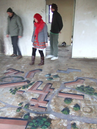
  • Jailbird’s eye view: I’m pretty sure that prison life in Norway is, compared to the rest of the world, very nice. But should you ever feel the urge to escape Bjørgvin prison in Bergen, you can now consult a gigantic satellite view of the grounds on the floor of the prison building. The images are copied from Google Earth, and are painted onto the floor as part of an art project by local students. Here is the Flickr set that alerted me to it. I think it looks quite excellent:

  • Surface in the wild: Microsoft’s Surface multitouch screen/GUI is now on display in several Sheraton lobbies in assorted cities in the US, and it features Virtual Earth (though not, apparently, 3D). Here is the Seattle PI’s video report. Virtual Earth makes its appearance half-way through:

    I want.

  • Google Earth API update: From a few days ago: Google Geo Developers Blog: New Earth API resources: Complete API Reference, Sample Code, Release Notes, FAQ. Mac support is still forthcoming.
  • Where is the path? Where is the Ordnance Survey?? Mapperz points us in the direction of Where is the path, a UK site that correlates locations on Ordnance Survey’s web maps with, among other things Google Earth for browsers. It looks fabulous on the video demo:

    Unfortunately, I didn’t get to try it myself, because:

    pleasetryagain.jpg

    Way to go, Ordnance Survey. Your free product is unusable, by design. Just as predicted.

Ogle Sweden

Extremely high resolution version

Ogle Earth is changing to Ogle Sweden — vicarously, for the next two weeks, at least. I’m road tripping around Sweden, on assignment for the Swedish Institute, taking 360-degree georeferenced panoramas and blogging the process over on Sweden.se. The blog’s format is still a work in progress, but do check it out — it will be officially launched in the next day or two.

Currently I’m in Umeå, and heading for well North of the Polar Circle, before driving back down to the Southern coast and back to Stockholm via the Baltic islands. There is much to see and do — Sweden is not short of sweeping vistas, and not small either — so I haven’t settled into a routine yet that gives me much time for Ogle Earth; we’ll see how that goes. Perhaps I’ll just cross post from Sweden.se.

Extremely high resolution version

In addition to posting the panoramas to the blog, I’m also mapping the trip. I was planning to create some KML manually for each day, upload it to a server and into an instance of Google Maps, but now Barry Hunter has just made my life a lot easier, releasing goKML.net for Google MyMaps just as I was wishing for something like it. Now, I can just create a MyMap for each day and use the KML it generates for that blog entry’s map, but also collect all these MyMaps into one big aggregate trip map — with no duplication of effort!

Oh, and as Barry noticed, Google MyMaps now produces GeoRSS as well, in addition to KML.

(PS the panoramas still need to get buttons. Meanwhile, click and drag to look around, press Shift to zoom in, Command (Mac) or Control (PC) to zoom out.)

Links: Sea ice animation; Google Earth search trend; FastSatfinder

  • Daily Arctic ice animation: Ross Swick of the US National Snow and Ice Data Center writes:

    The near real-time sea ice animation has made it’s way through our review process and been released on our virtual globes home page. It’s much improved as a result of everyone’s feedback. The released version includes both sea ice concentrations and sea ice extent. We’re also generating 3 files per day – 30, 60, and 90 day animations – so we can accommodate users with memory and bandwidth limitations. As before we’re using network links so the updates load automatically into GE at startup.

    The sea ice minimum is about six weeks away at this point and we can already see an above average amount of open water in the Arctic. As usual this is imagery, not data, so standard caveats apply.

    It’s definitely worth checking out the 90-day version if you can and then, when all the images have downloaded, dragging the time navigation handle quickly to and fro. The result is quite beautiful.

  • Developing countries heart Google Earth: Jonathan Thompson types “Google Earth” into the Insights for Search tool, and discovers that the highest regional interest for the search term is… in Sudan, where US export law forbids the download of Google Earth application altogether (and Google is complying). Jonathan speculates that perhaps its relative popularity is due to its unavailability there, or due to the publicity surrounding the application’s default Darfur Layer.

    top10queries.jpg

    If you look at the other countries on the top-10 list, it’s remarkable that all are developing countries, seven are predominantly muslim, and six are run by authoritarian regimes (Myanmar being another case where US laws prohibit the downloading of Google Earth). What’s heartening is that this list is pretty much the same as the one where widespread use of Google Earth would do the most public good.

    Residents of countries where Google Earth is forbidden can of course take heart in the fact that the same imagery dataset is available via the web, without US-mandated restrictions, on Google Maps. And soon, very very soon, Google Earth will be in the browser for all — though it will be interesting to see if such a browser plugin is subject to the same export laws as the standalone version.

  • FastSatfinder: This Google Earth browser plugin app lets you find the direction to a long list of geostationary satellites from any location on Earth (if it’s in your line of sight, duh). I can’t test it on my Mac yet, but no doubt it works in a similar fashion to the previously reviewed Dishpointer. FastSatfinder also comes as a $30 Windows standalone version, with extra features that I suspect are of use mainly to the dedicated hobbyist. (Via Boxier’s Weblog)
  • Street View, post-disaster empathy tool: In the latest update to Street View, all of New Orleans is visible, and three years on from Katrina chunks of it are still looking miserable.


    View Larger Map

    Are you empathising yet? Want to help? That’s the idea behind Street View in New Orleans, according to Louisana Lieutenant Governor Mitch Landrieu writing on the Official Google Blog.

    If it works, why not take it to the extreme — I wonder what Street View of a Darfur refugee camp in Chad might do? (Via James Fee)

  • Driving directions with the Google Earth API: Google Maps Mania flags a post on the Google Geo Developers Blog: “Simulating Driving Directions with the Earth API and Maps’ Directions API” (direct link to app) and makes a demo video.

Links: Street View downunder; no Olympic satellite view for China

  • Australia, Japan get Street View: Amazing — Australia is now smothered in blue Street View lines in Google Maps — including some of the most out-of-the-way places you can imagine:


    View Larger Map

    ozsv.jpg

    The Australian‘s take: “Privacy advocates say Google’s gone too far,” though not, it turns out, Australia’s Office of the Federal Privacy Commissioner, which thinks Google’s approach is fair dinkum enough. Japan too gets some of its main cities covered. Thanks to Claudia Carvalho for the tip.

  • Olym-pics not for the Chinese: Google’s recently updated satellite imagery of the brand-new Olympic stadiums in Beijing — which would provide ample opportunity for the Chinese to feel proud — is alas not available to ordinary Chinese, as inside the Great Chinese Firewall Google’s Chinese-language Ditu Maps service does not have a satellite imagery layer at all. Because, you know, all those domestic terrorists would never dream of using a proxy server to maps.google.com.
  • OneGeology outputs to KML: It turns out that OneGeology, previously flagged on Ogle Earth but not tested due to browser limitations, outputs to KML, as Hypocentre points out Now that I’ve had access to IE7 for a bit, I can confirm that the exported view-based network link works great in Google Earth. All Points Blog also lauds the data, but comments that the site’s technical underpinnings is a bit dated. As far as I’m concerned, the KML links for the regional layers serve all my needs — it would be great to offer them as a list of links on a plain-vanilla web page that don’t depend on a small subset of browsers or the map view — I know where Africa is:-) Oh and a KML layer with the key would make it perfect.

    onegeo.jpg

  • 3DXplorer – new Java-based virtual world: Serendipitously, just a few days after Avi Bar-Zeev clarifies the difference between two different kind of “browser-based” 3D virtual worlds/globes (one kind requires a plugin be installed, the other relies on the browser’s own resources — which is a much harder feat to pull off) an avatar-driven virtual world of the second kind is announced: 3DXplorer. Tantalizingly, it supports COLLADA models of the kind made by SketchUp and found in Google 3D Warehouse. In other words, you can create your own virtual worlds on your own website, populate it with existing 3D content, and let anyone with a free 3DXplorer account visit. That could well be a winning formula, with a free hosting option for low-traffic sites and paid options that are competitive with Second Life, depending on usage patterns. It runs in java 1.6, which alas Apple has been tardy shipping as a default with OS X (it’s still at 1.5). The main constraint, I suspect: It doesn’t look as slick as Second Life.
  • Mapufacture + GeoCommons: Geoweb pioneer Mapufacture, with its early support for syndicated georeferenced content via GeoRSS, is being acquired by FortiusOne, which is democratizing access to complex GIS databases via its GeoCommons platform. As Mapufacture’s Mikel Maron, Andrew Turner and FortiusOne’s Sean Gorman explain it, the two services are complementary and hence a perfect fit — Sean Gorman:

    The long term vision has been to eventually fuse the personal and dynamic data of the GeoWeb (long tail) [Mapufacture] with the static and statistical data of GIS (short tail) [Geocommons].

    I think it’s wonderful that there is consolidation afoot among the social geoentrepreneurs — there are some very big fish in the geospatial pond.

  • Earthmine update: O’Reilly Radar updates us on progress with Earthmine, which is working on an API to integrate its “Street View on steroids” into third party web sites. Don’t know about Earthmine yet? You need to check out this video.
  • Landsat to go free: Announced today: 35 years of archived Landsat imagery will be made freely available on the web by the end of 2008. The U.S. Geological Survey will be hosting the data, which is good news — the USGS is an enthusiastic adopter of KML for many of its other projects. Depending on how comprehensively this dataset is integrated with Google Earth et. al., we’ll soon be able to browse the Earth in time as well as in space.

Google Sky lawsuit dismissed

That demonstrably frivolous lawsuit filed by Jonathan Cobb back in February 2008, alleging that Google stole the idea of Google Sky from him? Dismissed. This just arived in my feed reader via the RSS feed tracking the case:

Cobb v. Google, Inc. et al Docket Report Updated 2008-08-01

MEMORANDUM OPINION, The Court GRANTS defendant’s motion to dismiss and DENIES plaintiff’s motion for declaratory judgment. Signed by Judge Richard J. Leon on 7/30/08. (kc) (Entered: 07/31/2008)

ORDER granting defendant’s Motion 43 to Dismiss for Lack of Jurisdiction; denying plaintiff’s Motion 44 for Declaratory Judgment. ORDERED that judgment is entered for defendant. SO ORDERED. Signed by Judge Richard J. Leon on 7/30/08. (kc) (Entered: 07/31/2008)

This case tracking page should soon be updated with that new information.