- Submillimeter astronomy as KML: Yet more astronomy content gets the KML treatment, making it usable in Google Sky. Orbiting Frog has assembled a layer collecting astronomical objects that are radiant at sub-millimeter wavelengths, and has just made it available for all to download, “thanks to help from the Canadian Astronomy Data Centre (CADC), the Joint Astronomy Centre (JAC) and my colleagues at Cardiff University.” Eye candy is available over at Flickr. There is plenty here to explore.
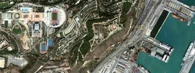
- Barcelona censored: The Spanish-language Google Earth blog notices that with the latest update, bits of Barcelona are now censored. What gives?
It’s the usual story. Satellite imagery got replaced by higher-resolution aerial photography, this time by the region’s Institut Cartogràfic de Catalunya (as per the credits). You can still see the old imagery in Google Maps here for a while longer, until Maps gets the update.
Before:
After:
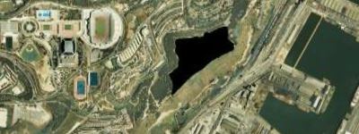
Catalonia’s governmental GIS office gets to censor those bits it wants to of aerial photography. (Satellite imagery, on the other hand, is beyond its jurisdiction.) At least the censorship is obvious, as opposed to camouflaged. (Entire update is listed below the fold for archival purposes.)
- iPhotoToGoogleEarth 2: Version 2.0 of the free iPhotoToGoogleEarth iPhoto export plugin is out, writes Craig Stanton. It works with iPhoto’08 in the latest version of iLife.
- Automator actions for Google Earth: Got Mac? Alasdair Allan has written two Automator actions for Applescript to switch from Earth to Sky, and back again. (Why not use in conjunction with the Google Earth Action Pack and/or GPS Automator actions…)
- GEMMO: Google Earth Hacks‘ Mickey Mellen is coming out with yet another Google Earth-based game, Google Earth MMO, now in a private beta. The cool bit? “All gameplay (including battles, shops, messaging, etc) is done completely in Google Earth with no add-on software or web browser calls required.” More here.
- Ads for online map makers (like you): You get the most of the money for ads showing on your websites, so why shouldn’t you also get money for ads on the maps you created? That’s the thinking behind one of the new features of Map Channels, which now lets you create your own Google Maps-based maps + content and then add ads using Lat 49’s “mapvertising”. The latest upgrade to Map Channels also improves KML support.
- Feature extraction from imagery: Awesome: Satellite imagery provider Spot Image is offering free imagery to researchers to help develop automated feature extraction tools that can then be used by the likes of GeoNames to offer more tan just point-based name tags. Writes GeoNames’ Marc Wick:
Features that we think can be extracted from 2.5m imagery are city contours, airports, streets, shore lines, lakes, rivers and others. We believe this is a fantastic opportunity for researchers and student-works to find algorithms for feature identification and extraction. Drop me a line for more details if you are doing research in this area and would like to work on this challenging task.
[…] It will be a gigantic step forward for the availability, quality and coverage of free geographical data on global scale.
- GeoServer: GeoServer 1.6.0 is out, and among other things it features “improved connectivity to Google Maps/Virtual Earth/Yahoo! Maps, leveraging better integration with OpenLayers as well as bug fixes for our Google Earth support.”
- GPS to Illustrator? A reader asks a question that I don’t know the answer to: He’s “searching for Mac software that converts [GPS] tracks to vectors (to be used in Illustrator). I was as wondering if you could steer me in the right direction? If no mac software exists, are there Windows ones?.”
- GeoLily! Who needs geocoding when you have geoLily?
- Microsoft Sky: Microsoft’s answer to Google Sky, WorldWide Telescope, looks set to be launched on February 27.
- 360Cities update: Jeffrey Martin writes: “You might be interested to know that 360cities.net has had a facelift to its homepage. We’ve also added about 20 cities… Including few excellent places such as Kolkata :-)”
- Star Wars! The rogue spy satellite has been shot down. Alan Clegg has a post linking to a KML overlay that shows you where and how it happened.
- How To Get On Google Maps Without An Address: Short answer: Get a PO Box.
- Super delegates: Democratic superdelegates, mapped as a KML file. The Official Google Blog has more.
- HeyWhatsThat Cosmic Visibility: Listed here better late than never, this cool Google Maps-based tool lets you visualize night sky events such as yesterday’s lunar eclipse. There’s added functionality for the Moon and Mars too.
- Traffic sensor web: Back in 2006, this was a high-end experimental feature for Honda drivers in Japan; now Nokia is busy democratizing the technology — where you GPS phone acts as a node in a traffic sensor web, relaying driving speeds to a central processor, and benefiting from live congestion information gathered from others GPS phones. It’s such a good idea that it is just a matter of time before we take it for granted.
- New Blog: There’s a new blog on the block: Where On Google Earth? posts a screen grab from Google Earth and then lets users guess where its from. Winners get bragging rights.
February 19 Google Earth imagery updateL:
New high resolution:
Americas:
- Canada: Significant amount of British Columbia, Oxford County (Ontario)
- USA: Madera (CA), Fernly (NV), Silver Springs (NV), Yerington (NV),
Cambria (CA), Creston (CA), Delaware, Connecticut
EMEA:
- Spain: Avila, Burgos, San Sebastian
- Portugal: Lisbon
South Africa: 2.5m imagery for western half of the country
Asia & Oceania:
- New Zealand: Auckland, Wanganui Province, Tararua Province
- Australia: Sydney, Newcastle
Updated Imagery:
Americas:
- Canada: Vancouver
- USA: Portland (OR), Bay Area (SF, Oakland, Peninsula), San Simeon (CA),
Morro Bay (CA), Garden Farms (CA), San Louis Obispo (CA), Arroyo
Grande (CA), Nipomo (CA), Santa Maria (CA), California City (CA),
San Bernardino County (CA), Riverside County (CA), Salt Lake City (UT),
Denver (CO), Kalamazoo (MI), Detroit (MI), Hardee County (FL),
Martin County (FL), Tampa (FL), Philadelphia (PA), Boston (MA)
Onodaga County (NY), Norfolk (VA), Island County (WA), the state of
Hawaii, the state of Ohio, the state of Louisiana, the state of Virginia,
and the state New Jersey.
- Cuba: Havana
- Brazil: Sao Paolo
EMEA:
- France: Tours
- Italy: Torino
- Spain: Almeria, Logrono, Pamplona, Santander, Segovia, Valladolid, Alicante,
Bilbao, Castellon, Cordoba, Coruna, Costa Blanca, Elche, Gijon, Huelva,
Leon, Oviedo, Salamanca, Vigo, Vitoria, Catalunya, Andalucia
- UK: Kent, Norfolk
- Switzerland: Zimmerburg, Pfannenstiel
- Denmark: Copenhagen
- Finland: Helsinki
- Norway: Oslo
- Iceland: Reykijavik
- Ukraine: Kiev
- Latvia: Riga
- Serbia: Belgrade
- Kenya: Nairobi
- Senegal: Dakar
Asia:
- Turkmenistan: Ashkhabad
- Kyrgyzstan: Bishkek
- Myanmar: Rangoon
Updated Terrain: State of Arkansas
For the inquiry about GPS tracks as vectors in Illustrator. You might take a look at Avenza.com. Their MAPublisher software is excellent and has been developed for years. It is a plug-in for Illustrator and they recently developed a plug-in for Photoshop to deal with raster images that have geo metadata such as GeoTIFFs.
(http://www.avenza.com). Both are great products.
Cheers,
Keene
There’s a free online converter to turn a GPX file into a shapefile:
http://freegeographytools.com/2008/two-online-vector-gisgpskml-conversion-utilities
Search the above site, and you’ll find other converters as well. Once it’s in shapefile format, you can convert it to vector EPS format online at MapShaper:
http://freegeographytools.com/2007/simplifying-line-and-polygon-shapefiles
There’s also a command-line converter that turns shapefiles into SVG files:
http://www.carto.net/papers/svg/utils/shp2svg/
I think there’s something wrong with that “eye candy at flickr” link… it links to “https://www.ogleearth.com/2008/02/thanks%20to%20help%20from%20the%20Canadian%20Astronomy%20Data%20Centre%20(CADC),%20the%20Joint%20Astronomy%20Centre%20(JAC)%20and%20my%20colleagues%20at%20Cardiff%20University.” uhh… yeah… that’s not flickr… :)
Link fixed, thanks!
Hey! They stole our meme! Where on (Google) Earth? has been played in the geoblogosphere (that’s “geology blogosphere”) for over a year now. WoGE #112 was just posted (and solved) this morning.
Show us some love, Stefan!
Good point, Ron. I should have mentioned your prior art in the post. Still, the more the merrier, right?
Sure, I love challenges like this and I thank you for pointing it out. I’ll probably become a regular.
Mostly I want to see credit where it is due. Brian Romans at Clastic Detritus initiated the Where on (Google) Earth? series in January of 2007 and I was the one who suggested that we pass it around among the winners. It’s turned out to be a great tool for building community and awareness amongst the geology bloggers out there.
I’m all for building geology/geography awareness, and to the extent that this new blog does that I’m agreed, “the more the merrier”. I can’t speak for Brian about how he feels about someone else profiting from his idea – especially without attribution. But I guess more than anything I’m disappointed we’ve been flying under your radar with this idea for more than a year.
Ron, I am (or was) pretty sure I linked to something like this a year or more ago, but now I can’t find the link (of course). (Maybe I remember it from Frank’s Google Earth Blog?)
I don’t recall it, from either you or Frank, and I think I’ve been pretty diligent in following both of you since your respective inceptions (though it’s entirely possible I simply missed it).
By the way, I owe you thanks for cluing me in on the GigaPan beta test a couple of months ago. I’ve ended up with one of the first batch of units and I’m now the third most prolific poster on that site. I probably wouldn’t have had that opportunity if it wasn’t for your heads up.
Keep up the great work!
I think your information about censorship in Barcelona’s Castell de Montjuïc is not accurate.
This installations belong(ed) to the Spanish Ministry of Defense. Recently the Castell de Montjuïc were returned to the city, but still remain there military antennas.
So censorship don’t comes from Catalan Government laws or institutions. It comes from Spanish Ministry of Defense and Spanish laws, that (unfortanately) ICC has to follow.
Richard Fairhurst’s GPS to Illustrator converter is at:
http://www.systemed.net/gpx/
Currently limited to OS Nat Grid but you could always ask him
Thanks very much for the link. I have actually been doing lots of playing with Google Earth too. Made myself a satellite tracker that you might like: http://orbitingfrog.com/blog/2008/02/25/satellites-on-google-earth/
This is a great blog, I have subscribed.
It seems like the links to the automator actions you mentioned in “GPS Automator actions” are all dead…
Anybody knows a good freeware solution to geotag my pictures on the mac? Using a nmea or gpx file. I don’t care if it’s command line, automator actions or a gui application.
For the Mac, there is a free utility called GPS Photolinker that you want to use:
http://oregonstate.edu/~earlyj/gpsphotolinker/
Where you get theese great adresses?
Thank you, great tools :)
DNR Garmin is also a good program to get GPX logs into shapefiles (including a good projection engine) and a couple other formats GPSbabel doesn’t do. From there, converting to SVG or an AutoCAD DWG is easy, and Illustrator can open both of those.
http://www.dnr.state.mn.us/mis/gis/tools/arcview/extensions/DNRGarmin/DNRGarmin.html