- Google Earth bug fix: Google Earth gets a bugfix update, to v4.2.0198. From the release notes:
- SpaceNavigator support for sky. [Works on the Mac:-)]
- Fixed several crashes in PhotoOverlay
- Reverted “Restrict time display to folder” checkbox default to off
- Fixed inadvertent photo flip for sperical PhotoOverlays with tilt less than 90
- Burning Man: Valery Hronusov posts the KML file of the aerial shots over Burning Man 2007.
- Bluetooth GPS for Nikon: This looks like the best solution yet for turning Nikons into GPS-enabled cameras: Red Hen Systems‘ Blue2Can, a bluetooth adapter. I want one.
- 3D Route Builder for Google Earth “is a powerful utility for fine grain control over paths directly in Google Earth. These can then be either built from scratch or based on existing KML or GPX exported and then driving the route at specific speed.”
- WorldView launch: DigitalGlobe is launching another orbiting camera on September 18 — WorldView I, reports Reuters. See the launch live here. Weird tidbit:
DigitalGlobe built the satellite in part with $500 million in funding from the Pentagon’s National Geospatial-Intelligence Agency (NGA), but it can sell the images commercially as long as their resolution is no sharper than a half-meter.
Says what law? I thought the only country for which US laws set resolution limits for imagery sold by US satellite companies was Israel. Or is this half-meter limit a new licensing restriction for WorldView? In any case, down the line this satellite and WorldView II will likely result in more frequent, more accurate updates for Google Earth.
- DrupalCon: It’s DrupalCon Barcelona 2007 on September 19-22, and Dan Karran will be there, touting Drupal as a GeoCMS.
- Nokia 6110 with GPS review: Steffen Nork tries the GPS tracking on the Nokia 6110, and likes it. On a related front: Ever since switching to Vodafone here in Cairo, the assisted GPS on my Nokia N95 is impressively quick — I’m getting a lock in seconds, and with partially obscured skies! Suddenly, the GPS on this phone is usable. It seems that your phone company provider makes a big difference in this regard.
- New Virtual Earth developer blog: Hannes’s Virtual Earth Blog (Via GIS Lounge and Virtual Earth / Live Map)
- ArcGIS Export to KML: James Fee has news of a update to Export to KML, version 2.4, for ArcGIS.
- KML to GeoRSS: In a reversal of how the production flow usually goes, BRIGHTi Geofeeder takes KML, Shapefiles, GML, Mapinfo or Autodesk files and converts them into GeoRSS. Free demo. (Via Virtual Earth / Live Maps)
- Google Maps upgrade: 54 more countries get data in Google Maps. Google Earth has had the populated places for a while, but now Google Maps is ahead in terms of road coverage. No directions from Kabul to Kandahar, however:-) At least not yet.
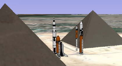
- Rocket Garden Visualizer: Google’s Lunar XPrize website contains one pedagogical tool that uses Google Earth. Give the form an address, and you get a KML file back depicting life-size scale models of various rockets. Put them next to historic landmarks to get an even cooler context:
8 thoughts on “Links: Google Earth bugfix, Burning Man, 3D Route Builder”
Comments are closed.
What law? The law that says: “Don’t Bite the Hand that Feeds You $500 million dollars.”
Anyone have an educated guess as to the actual limit of the satellite?
the photo overlay works great now. i couldn’t align my panoramic photo i used for testing before, now it works great.
http://bbs.keyhole.com/ubb/showflat.php?Cat=0&Board=EarthTourism&Number=1004027&Searchpage=1&Main=1004027&Words=+smokeonit&topic=&Search=true#Post1004027
14.7MB high res panormaic overlay that is aligned to the horizon.
Good question Stefan. I’m curious myself. I’ve poked around a tad will limited success.
I did come across this nugget.
http://ecfr.gpoaccess.gov/cgi/t/text/text-idx?c=ecfr&sid=3f0840ff01b1c770ab184a5baf9c2f9a&rgn=div5&view=text&node=15:3.1.2.4.17&idno=15
Subpart C. 960.13 Prohibitions
“It is unlawful for any person who is subject to the jurisdiction or control of the United States, directly or through any subsidiary or affiliate to:
(a) Operate a private remote sensing space system in such a manner as to jeopardize the national security or foreign policy and international obligations of the United States;”
KoS
i think the .5m limit is set by contract, not law…
for security it’s more the date that’s a threat than the resolution…
satellite footage that is very recent is much more dangerous than old highly accurate footage…
since china, russia and other non nato countries have spy satellites the western worlds security concerns should be on reposition their stuff of re-camouflage it every other day if it is very sensitive. and if it’s well camo’ed then there’s no need to change position of the stuff in question. they can use their own satellites to confirm how good the camo is, no???
While I can see the NGA’s motive for limiting the resolution over US military installations, I don’t see why the rest of the world can’t get full-resolution imagery. What does the NGA stand to gain from making sure imagery of Darfur is kept at 2 pixels per meter?
No offense smokeonit. I know this is splitting-hairs. A contract has the force of law. Anything in the contract(except unlawful items) is considered law, so to speak, between the parties who signed contract.
At least that is what I understood from my business laws classes. Or I know nothing about it. :)
http://dictionary.law.com/default2.asp?selected=337&bold=||||
Stefan…not sure if you read the link I provided in my last post. You may want to take a look. There are some other interest nuggets regarding access to the imagery by the host country, but also the country being image.
KoS
KoS:
i understood “law” in terms of a government agency requiring the SAT company to comply to certain rules…
of course the contract angle is a good one…
Smoke…here is a good, brief explainition of law and contracts.
http://smallbusiness.findlaw.com/business-forms-contracts/business-forms-contracts-overview/business-forms-contracts-overview-law.html
When it does come to law and those things associate with it. I can totally understand why people hate lawyers. They make things way too complicated at times. Especially when it doesn’t go your way. :)
KoS