AAAS Burma satellite imagery documents human rights abuses

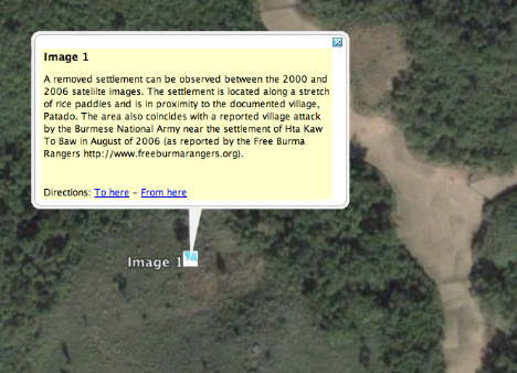
Burma has been in the news this week, but the human rights abuses being perpetrated by Burmese government forces have been ongoing for a generation. In one region, a separatist movement by the Karen people is habitually repressed by attacking and displacing civilian villages on the grounds that they provide support to separatist fighters.

Such tactics are evident on satellite imagery, and now an initiative by Lars Bromley at the American Association for the Advancement of Science (AAAS) has commissioned before-and-after imagery to show the effects of this ongoing ethnic cleansing program.

The AAAS has written a news release linking to the detailed report containing the imagery, which in turn link to a KML file that georeferences those images on top of Google Earth:

Before (Ikonos, Nov 11, 2000):

beforeburma.jpg

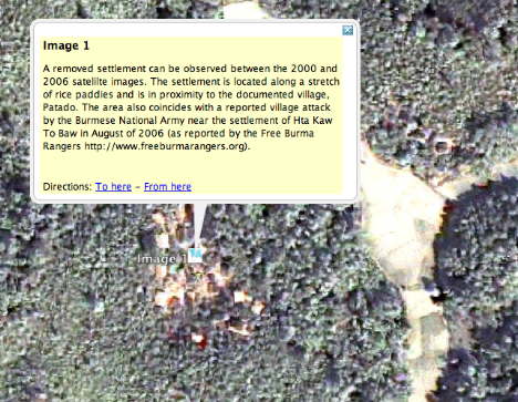
After (Quickbird, June 24, 2007):

afterburma.jpg

This isn’t the first time that geospatial technology has been used to document human rights violations. Back in June 2006, the AAAS documented the razing of villages in Zimbabwe, and later also the effect of the 2006 war in Lebanon and the ongoing crisis in Darfur. In April 2007, a layer documenting the Darfur crisis prepared by the US Holocaust Memorial Museum and others became a default layer in Google Earth. North Korea has also been extensively annotated. What all these initiatives make clear is that when it comes to documenting the effects of human rights abuses on large populations, satellite imagery can do valuable service in lending credence to reports of violations and in raising public awareness.

The AAAS report on Burma makes for interesting reading, especially regarding what’s next:

AAAS also is investigating the possibility of developing a Web-based geospatial information portal of the Burma conflict. This portal would, to the extent possible, summarize attack-related information and provide access to satellite imagery to a select group of NGOs. Lastly, AAAS will begin making available, via a Web site, its tools for roughly matching village name spellings with coordinates and available satellite imagery. Ideally, all these tools together will improve information-sharing regarding the conflict in Burma, and improve collective understanding and planning efforts. […]

Other organizations are encouraged to consider this content as available for any future media project using Google Earth. For example, a Burma Google Earth product modeled after the Darfur layers released by the U.S. Holocaust Memorial Museum might be ideal.

Matching village names as used by their inhabitants to the transliterated names on maps was also one of the main challenges in making the USHMM Darfur layer. Having such collaborative tools exist on the web would greatly facilitate the work of human rights organizations everywhere.

Less encouraging, once again, is how the media reported the AAAS announcement of the report this Friday. Because it was timely, the mainstream media gave it welcome prominence (See the NYT, MSNBC) but once again, every online news item I read fails not only to link on to the KML layer, but also the detailed report. The geoweb is not going to be transformative until the average news reader starts consuming georeferenced information published to a geobrowser, and that won’t happen until and unless news organizations start linking to such content. Bloggers link to source material all the time; why can’t journalists, especially if the “story” is about the release of georeferenced satellite imagery?

“Mysterious” radio burst referenced in Google Sky

Any story headlined “Astronomers Find Mysterious Radio Burst” gets clicked on by me faster than you can say “colliding neutron stars”. Space.com reports on the research paper published today in Science Express (ArXiv.org has the whole paper for free). Space.com’s article also has an accompanying image pinpointing the burst’s location in the sky, near the Small Magellanic Cloud in the southern hemisphere:

070927_magellanic_cloud_02.jpg

Because that image exists, and because Google Sky exists, these two had to be mashed up. Voila:

burstinkml.jpg

As usual, play with the opacity slider to compare the overlay with the, erm, underlay.

Some caveats: Google Earth/Sky’s image overlay tool still uses polar coordinates only; real-field-of-view images get difficult to position near the poles, especially at larger scales/wider angles. Still, the fit is quite good, especially when considering that the location of the radio burst is somewhat vague.

Just as geographers have begun to append their papers with KML files containing the relevant overlays and data, I hope that astronomers and astrophysicists start doing the same soon. After all, 250 million computer screens can now display such a discovery accurately, and in the wider context of the sky. Surely science outreach doesn’t get any easier than this?

Social Google Earth, anyone?

Over at RealityPrime, Avi Bar-Zeev riffs and speculates on the strong hint that Google is building a social network application with a 3D component. What could it possibly entail?

Imagine it more concretely: repurpose the GE sidebar for social networking functions, “friendmarks” instead of (or adding to) placemarks, “stuff to do” instead of (or adding to) layers to view. And then let people populate and build this new fictional world however they wish, using SketchUp as the main modeling tool.

Read the whole article.

Which installation did the Israeli bombing raid in Syria target?

Which installation did the Israeli bombing raid in Syria on September 6 target?

That question has been been on the minds of quite a few pundits since news outlets began reporting on the night-time raid by Israeli jets deep in Syrian territory. At first, very little was known, as sources were uncharacteristically mum. Slowly, it became apparent that there was a nuclear angle, and a North Korean angle.

Meanwhile, can we figure out from the available piece-meal evidence what precise location this raid might have targeted?

Blake Hounshell of Foreign Policy’s Passport blog was the first to have a go, using Google Earth, no less. His georeferencing hints came from this Times of London article:

An audacious raid on a Syrian target 50 miles from the Iraqi border was under way. […] The target was identified as a northern Syrian facility that purported to be an agricultural research centre on the Euphrates river.

Hounshell then extended a line 50 miles from the border along the Euphrates on Google Earth. The line ended in Al Mayadin, which alas is not in high resolution. Hounshell’s thesis was that an area of interest to western intelligence would have been imaged by the likes of DigitalGlobe, and that it would therefore be in high resolution in Google Earth. Because Al Mayadin wasn’t, Hounshell felt that his speculation was likely wrong.

I too went looking for the possible location, and found a good candidate, but didn’t feel there was sufficient circumstantial evidence to back up my speculation. Until tonight. Hounshell was closer than he thought.

What did I do? I triangulated three pieces of information.

1. I turned on the default Google Earth layer showing where DigitalGlobe’s imagery was taken in 2007. This most recent imagery is not yet in Google Earth, but you can tell from the layer what area was covered:

allsyria.jpg

2. I assumed the 50-mile line was an approximation, probably converted from kilometers, and that the line from the border doesn’t have to follow the course of the Euprhates:

secondline.jpg

50miles.jpg

Putting these two pieces of information together, it looked like there was indeed a region about 50 miles from the border on the Euphrates where DigitalGlobe imagery had recently been taken.

3. I then turned on the full Google Earth Community layer and went looking for “agricultural research centers” in the area that might have been annotated by one of the 900,000+ contributors. I was surprised to find precisely what I was looking for:

popup.jpg

Yes, there is an agricultural research center at Dayr az-Zwar, 50 miles from the Iraqi border, on the Euphrates, underneath a strip of recent DigitalGlobe imagery. Being the skeptical type, however, I felt that this was just too speculative, so I refrained from blogging it. But tonight, the Times of London actually names the town near where the raid took place:

Israeli special forces had been gathering intelligence for several months in Syria, according to Israeli sources. They located the nuclear material at a compound near Dayr az-Zwar in the north.

This latest article doesn’t mention agriculture (and nevermind that Dayr az-Zwar is not really “in the north” of Syria) but the ensemble of information I think now makes a pretty good case the the place that was bombed was a research center of Al-Furat University’s faculty of agriculture in Dayr az-Zwar.

popup2.jpg

(Bonus Syrian WMD geography lesson: Charles Levinson at Conflict Blotter links to a Jane’s Defence Weekly report about an explosion a few months ago at a “missile installation for manufacturing chemical weapons southeast of Aleppo”, at As Safirah. Interestingly, he notes:

I was surprised while reading today’s coverage to learn that [Israeli tabloid] Yediot Aharonot actually hires the Digital Globe, a commercial spy satellite, to photograph Syrian and Iranian military installations. Apparently they’ve been doing this for years.

That’s probably why you can see the location of this munitions factory in Google Earth in high resolution here.)

[Standard disclaimer: As much of the information above comes from intelligence sources leaking to the press, any or all of it may be wrong and intentionally misleading. Read critically!]

PS: I just thought about phoning the agricultural research center in Dayr az-Zwar/Deir EL-Zoor and asking them if they’ve had any bombing raids recently, but it’s very late there right now, and besides, that would be tantamount to actual reporting, which would go against the bloggers’ ethic:-)

Links: Hasselblad2KML, OZ house numbers, Xplage, Google Sky orrery

  • My new object of lust? The Hasselblad H3D DSLR: 39 megapixels for 26.5 kiloeuros (USD$37,500) in a full-frame medium format camera. Obviously, it comes with integrated GPS and the ability to export the data as KML. Alas, it will remain the stuff of dreams.

    h3d_2.jpg

  • House numbers down under: Michael Smalley notices that streets in Australian cities get house numbers. Only in Maps (not hybrid) and not (yet?) in Google Earth.

    drumalbyn2.gif

  • Xplage: “Convert X-Plane [flight simulator] datagrams to Google Earth ‘moving map’ displays.” For Mac and Linux…
  • Google Sky orrery: Barnabu.co.uk adds a virtual orrery as a screen overlay to Google Earth, so you see the relative positions of the planets as they orbit the sun corresponding to the view from Earth at a given time.
  • Superoverlay 2.0 Beta: Valery Hronusov’s Superoverlay application for making Super-Overlays reaches version 2.0 beta.
  • North Korea watched: Here is a gem, found while trawling through the internets for georeferenced human rights material: North Korea Uncovered, “The most authoritative, publicly available map of North Korea on Google Earth”. Check out the high-resolution overlays for some of the prison camps. By North Korean Economy Watch.
  • 3D UI alert: CrunchGear has a video preview of XTreme Reality 3D, as-yet unreleased software that lets you use hand gestures in front of your webcam to control applications, including Google Earth. It’s like Atlas Gloves, blogged last year, but without the need to to use lights, as the object recognition algorithm seems to have gotten better in the meantime. (Thanks Johnathan!)
  • EditGrid collaboration: Another way to engage in collaborative mapmaking: Using the access controls of online spreadsheet applications and then converting the contents of a spreadsheet to KML. Here’s an example of how it’s been done using EditGrid to map POIs in Croatia.

Pleiades: Georeferencing ancient history

Pleiades “is an international research community, devoted to the study of ancient geography.” All the objects in its fast-growing database are referenced as GeoRSS and KML. Import Cartography‘s Sean Gillies is Pleiades chief engineer, and he has been busy stuffing the database. In high-resolution areas, placemarks often do correspond to interesting features on the ground:

telandros.jpg

There’s hours of hunting here for ancient world buffs, and especially so if you live in the area:-) Given that these placemarks have time-based period data for when they were inhabited or relevant, it would be great to eventually be able to integrate these into the Google Earth time browser via KML’s <TimeSpan> tag, so you could surf through history, seeing places appear and disappear as civilizations rise and fall.

360Cities does KML 2.2 panorama spheres

360Cities, one of a new crop of georeferenced city panorama photography sites (see also Arounder and ViewAt, reviewed here), is now using Google Earth 4.2’s ability to render embedded spheres using KML 2.2’s PhotoOverlay tag, writes 360Cities’ Jeffrey Martin. All 2,700 panoramas are being converted, but work has just started, so it will take a while. One city that is ready is Stuttgart. Check out its KML file.

stutt360.jpg

Jeffrey adds:

We’ve updated the 360cities.net homepage also – 27 cities now and many more to come. It is really turning into a monster ;-)

(See also the Gigapxl and Gigapan default layers in Google Earth for more PhotoOverlay goodness.)