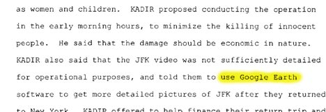
You’ve no doubt today heard about the plot to blow up some fuel lines to JFK, with three people arrested and one still sought. A friend who is stuck doing the Saturday newsdesk shift sent me this, scanned from the indictment:
In a related matter, earlier this week, plans for the new US embassy in Baghdad showed up online. The relevance of that leaked information was downplayed thus:
“The actual information that was up there was purely conjectural and conceptual in nature,” spokesman Jeffrey Willis said. “Google Earth could give you a better snapshot of what the site looks like on the ground.”
Noted! Are you listening, insurgents?
What is the problem here? Actually, neither Abdul Kadir, “a citizen of Guyana and former member of its parliament“, nor Jeffrey Willis are GIS or security experts, and neither are qualified to make such statements. It would be a pity if their opinion were to be used as “evidence” for the need to censor Google’s high resolution imagery.
Whether or not Kadir told them to use Google Earth is actually quite irrelevent – especially if it did not produce any meaningful analysis on the part of the conspirators. I’m willing to bet the house that the results of their analysis was meaningless in comparison to one individual having worked there. Google Earth (or any imagery) has nothing to do with that fact of the case.
In relation to the comments made by Berger Devine Yaeger – it appears that we have yet another organization not willing to own-up to a mistake, and not willing to signify the fact that because they are an architectural firm – they should have more knowledge of visualization technologies than the public. To say otherwise is highly misleading, and only serves to place more attention on their deflection.
The embassy plans being available to the public was a 3D rendered blue-print, essentially – completely different scenario from viewing anything from the Nadir view, which would require an incredibly limited source of information about any building location, and require the highest amount of security and anylsis knowledge to discern anything, if anything, about a location.
Continues to boggle my mind. I hope that firm is asked why they decided to deflect instead of own-up.