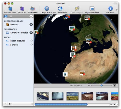
Ovolabs’ Geophoto is a new stand-alone virtual globe application for the Mac that lets you georeference and visualize photo collections. These collections can be your own iPhoto albums, Flickr images tagged by group, author or keyword, or even “photocasts”, photo RSS feeds. If you are familiar with iTunes or iPhoto, you will immediately recognize the Mac-standard GUI for media management. There is practically no learning curve to this application.
And yet I’m conflicted about Geophoto. It is exceptionally simple, but it costs $50 for far less functionality than what you get in Google Earth (and its network link). That’s quite an audacious proposal.
So, quickly, my likes and dislikes about this application:
Likes:
- It is goodlooking and it is simple to use. The use of a Mac-standard interface for a virtual globe is well done.
- It is a standalone application, so it can do nifty visualization tricks like having photo popups merge as you zoom out.
- It does not require an internet connection to run, so you can view your photos offline, if you like.
- You can have multiple globes open at the same time.
Dislikes:
- In the age of Google Earth and NASA World Wind, the resolution of this globe is terrible. Three years ago, this would have been impressive. And while I sympathise that getting high resolution imagery is a very expensive proposition, that’s the competitive landscape we find ourselves in now, and have been in since June 2005.
- No layers other than the physical Earth. No roads, clouds, cities, etc… No height mesh (DEM) data either.
- Georeferencing is a very coarse exercise. You have to do a search for a place, and if it finds it, you then get to set your photo to that place. There is no way to georeference a photo manually. Not that there is much use for such a feature, as the map is so coarse. (BTW, the search feature queries Geonames.org, so you have to be online to georeference. The imagery is a local copy of NASA’s Blue Marble Next Generation.)
- There are no good navigation controls. You can’t pan and tilt, for example. And when the globe does move to a specific photo, it does so abruptly, without the organic feel that Google Earth or NASA World Wind have.
So who is this for? My Dad? He’s an avid photographer and not so much a technologist, but even he’d like to show what street corner a photo was taken from, rather than what city. People that are really into Maps and Macs? They’ve already discovered Google Earth, Flickr, and the different ways of using them together.
And it’s not as if the geospatial Mac market beyond Google Earth is a wasteland. If you want lots of layers full of context, there is Matt Giger’s EarthBrowser ($24). If you want to georeference your photos, you can use Google Earth and Geotagger (free), or your GPS device and Geotagging Automator Actions ($15). You can also export your georeferenced iPhotos to KML with iPhotoToGoogleEarth (free). And if you want to browse Flickr photos in Google Earth, there’s Trippermap ($10/year).
In other words, much as I like the idea of Geophoto, I don’t think it’s feasible as a $50 application.
Hi :-)
Your blog is simply wonderful!
I’ve linked 3 posts of yours in a post about foto-geotagging resourses in my blog.
Are there some other tools?
Thanks :-)
And yet…
When is Goople gonna launch a Maacgle?
What I mean is:
is it not likely that Apple and Google may merge some assets at some point in near or near-near future?
That would make either this kind of stand alone app totally google earthed at once (localised on desktop??) And/ or available altogether on Internet. What the heck.
That’s what people want: a usefull tool.
Cheers,
Jerome
http://www.geo-games.eu
I have a friend whose photo collection was used as ‘landmarks’ for Google Earth through the efforts of his friend. Most of his photos are pictures of icebergs and mountain summits. Well, personally I was kind of envious because not all the time that Google notices someone’s project. Is this tool that you have here works in the same way as what my friend’s friend did for him?