Following up on the embryonic feature wishlist for Google Earth embedded in the long post from yesterday, Michael of the Google Earth team would very much like to know: What is your most urgent feature request/improvement for Google Earth?
I have a couple myself I’ll start off with.
- A more accurate, higher-resolution height data mesh. Currently, the peak of my favorite mountain, the Matterhorn, falls between datapoints, and the result is this:
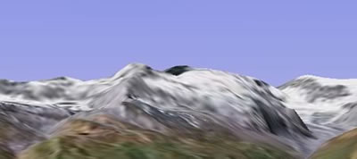
Instead of this:

In many places, especially mountainous areas, getting more height data points would do more for the accuracy of the view than getting higher resolution imagery.
- Auto-suggestion when searching for placenames, like this. Perhaps even access to georeferenced directories like GeoNames?
- The ability to look in all directions from any given location. The ability to move vertically without first having to look down.
- A way of getting better resolution at the poles, and better base imagery, especially now that the International Polar Year is soon upon us (and I can promise you, the scientists are planning a big bash).
- The ability to link to a location in Google Earth directly from within HTML (as described in this post, perhaps). The ability to link from one KML file to another.
What else? Scriptability? The ability to render WMS data natively? Support for OGC standards? What’s most urgent?
(On a different note: Michael noted that the Google Earth file of the discovery locations of 26,000 meteorites that I linked to yesterday is the product of the hard work of Google Earth Community member Majoska, who’s been building the database for several months now, with the help of many people. It is worth linking back to Majoska’s post, where the project is constantly updated and where credit is properly due.)
1. Searches for geographic features or locations should work MUCH better than they do now! I consider the search feature in GE to be basically worthless (which is ironic).
2. Labels for places and geographic features should appear ‘sooner.’ What I’m trying to say is that if you are looking for a specific place (town, mountain, lake) you pretty much have to be right on top of it and zoomed all the way in before any labels appear. This (combined with request #1) make it REALLY hard to find somewhere unless you already know where it is.
3. WMS integration would be HUGE!
4. It would also be cool if an image loaded in from a network link would not disappear while the next image is loaded. In other words if I have a dynamic image layer and I zoom in, the previous image goes away while the new image is downloaded.
(1 and 2 are desperately needed! 3 and 4 would be nice to have.)
Well, at the risk of sounding like a KML geek who doesn’t think big (e.g. 1 ft LIDAR elevation for the whole planet!), here are my immediate needs–
1. Making Network Links more user friendly
a. For links that Refresh on user request, have a button on the interface that refreshes ALL of the links in the menu that are set to “On User Request”.
b. A more elegant time-out solution than an error message that the user can do much with.
2. Altitude dependent rendering and symbolization. Apparently this one is almost out the door–and that’s good news.
3. Time-stamp feature rendering. Haven’t seen it in person–just have heard the rumors. If they can figure out a schema that works, being able to show change over time–especially in 3-D–will be a huge step forward for data visualization.
4. Can I throw in a CSS sheet inside my KMZ so I can format some nice-looking tables without a huge amount of redundant HTML in my tags?
5. Easy-to-look-up metadata for the default globe imagery–i.e. a button that tells the user when the image in the viewer was collected and by whom. Had a potential client ask me if the 15m Landsat imagery from 1999/2000 was showing last week’s snow…
BT
I want an easy way to get information about the satellite images. There should be some very easy way of getting information such as when the image was taken, by what satellite and such. I am a new user of Google Earth and such a feature might already exist somewhere, but I have not seen it.
Gustav, that’s a very good idea.
Just thought of another one, mentioned before: Polishing off the time browser and getting it into the free version. I think that will create whole new genres of content.
– ability to display pictures perpendicular to the surface (so I can put picture up where there are buildings etc.)
– alternatively, let me specify topology of the surface (I can create a building shaped lump) which I can then add a photo to as an overlay
– extension to kml syntax so that with (1) I can describe a sequence of pictures which will change as I rotate (so the picture I see is the appropriate one for my point of view)
And longer term, some kind of extension framework (e.g. like Firefox…) that lets me extend Google Earth in other ways, rather than just by adding data (KML).
A
Stephan, re #5 (really a browser feature rather than a GE feature)
– maybe a diffent protocol would be more appropriate than a new type paremeter for
e.g. href=”gearth://lat=xx&lon=yy”
This would be trivial to implement as an extension in Firefox.
A
Adam reminds me of another obvious one, but which I’m pretty sure is already being worked on:
The ability to map textures (incl. photos) onto building facades.
Perhaps go all the way and be able to render all of a SketchUp model’s features natively?
– Up-to-date, all complete KML documentation and without inconsistencies/errors.
– The possibility, in KML, to add labels to paths/lines and polygons
– Improved KML syntax with more features
– Public API to extend Google Earth
How about a KML/KMZ search feature? Google Search already has cached most of them on the Internet. (filetype:KML inurl:KML)
Also, how about a connector feature to OGC services. CAT 2.0 would be good for finding data from other web services, libraries, or data stores. Access the OpenLS and SensorML stuff would be pretty cool too.
Before I go, one more thing about geographic data search, check out Jeremy’s site at http://www.mapdex.org. His team has it going on for searching geographic web sevices. (990+ servers w/ about 400,000 layers)
The ability to create and display information (placemarks/polygons) BELOW the Earth surface.
Its interesting to see these comments. I know everyone is curious to see what new features will ultimately end up in the next big update to GE.
Here are a few more suggestions.
1) Have better organization of MyPlaces. If you have many of these, it becomes a mess to manage. Perhaps move these to a pull down menu or have something akin to Bookmark managment. Or a floating palette like World Wind has would be nice. It frees up much more real estate for viewing the globe.
2) Related to #1, have a Favorite places where one can put a few commonly visited Places. This would be a subset of one’s MyPlaces collection
3) It has been said before, but the ability to search a KMZ/KML file in MyPlaces or in Layers. Not just a basic search but detailed queries, such as”where are all the meteor sites in Mexico”for example.
4)Integrate Instant Messaging, blogging and Video blogging directly into Google Earth. Provide tools to do this. There has been some work on this initially by others, namely integrating the Open Source Blosxom blogging tool into GE.
5) Have some better KML editing features built in. Such as the ability to show placemark names when you zoom in and rollover them for instance.
6) Have some plug-in functionality to support various media formats such as quictime, flash, Windows Media, etc. This perhaps giving you the ability to play movies, QTVR, audio, animations directly in Google Earth without linking out to browser.
7) Ability to toggle raster data off and just see vector data. Sometimes this is useful. ALso would be nice to be able to select the background color if you just have vector data turned on and no raster showing.
8) Ability to choose between baselayers for the Globe in preferences. Perhaps a DEM option, a Blue Marble option, the default and perhaps others. Provide better resolution for sea floor, similar to World Wind’s use of Blue Marble data.
9) Definitely the abilty to navigate subsurface whether its below water or below ground. Imagine the possibilities for visualizing caves and underwater features!
10)Add a light feature? The ability to show the world at night. Also to thrown an artificial “sun” onto an area you are zoomed in on and be able to place the light from any angle. Have the whole globe reflect the day/night cycle.
11)Ability to link to other KMZ files. This would be very useful and something users could get very creative with (as could advertisers)
12) Ability to zoom into a location and see the weather within a popup window. Kinda nice.
13) Perhaps add Greater Metropolitan Area boundaries as layer. If there is one thing you can do in Google Earth its see how our humanity is spread out. Showing the whole New York, LA, Houston and Chicago Metropolitan boundaries would be nice.
14)Provide good high res coverage for national parks, both domestically and internationally. Using Google Earth for detailed backcountry exploration is still a bit fuzzy. Include federal Wilderness Areas.
15)Provide ability to record audio directly into Google Earth so that you can add this to placemarks and tours in Google Earth. I can see this being useful for teaching and presentations.
Whew! Let’s keep our fingers crossed for what may come out next…
I meant to add several more items:
16) Ability to play an animation of placemarks and when the browser stops at each one, the pop-up window shows up automatically instead of having to stop the animation and click on the placemark to get the information.
17) Ability to show items like the Space Station and satellites in animated orbit. Not really that useful but just cool.
18) The ability to encrypt or lock KMZ files so that someone can add data and not have someone else maliciously change it.
I want scripting and plugin support in the client. This is one of my favorite things about sketchup- the ability to write quick plugins using Ruby. I am writing an application where I want users to be able to create specialized data by clicking on the map and then I pop up a specialized form. There just isn’t a good way to hook into that process right now.
Rodrigo’s suggestion reminds me of a similar one, though I believe it may already be on Google’s to do list, as Google Earth CTO Michael Jones mentioned it as something to do back in November 2005:
– Bathymetry data and sub-ocean mapping.
I would like to have a backbrowse button or navigation history list that could be used to backtrace movements. A limited history would work for those times where you get lost and want to backtrack a bit.
Not sure whether its something to incorporate into the GE interface itself, but from using it a lot, I start to get more and more interested in seeing some user statistics about Google Earth, and the places all the users visit (at what time etc…)..has there been any public data available about this? Could be nice to have a GE overlay which shows the traffic in Google Earth on Google Earth.
Something tells me that having usage data projected directly in GE itself would introduce some interesting feedback loops.
The Icon tag of ScreenOverlay and GroundOverlay is the same type as the Link tag of NetworkLink.
The Icon tag of ScreenOverlay and GroundOverlay is the same type as the Link tag of NetworkLinks.
Movable Type 3.2.
http://www.Johnbeckland.com/john-becks-land.html
Add a (coloured)light is extremely easy to implement, and could sum up to an enormous amount of new applications – Is mt. A visible from Mt.B? summed up with Atmosphere, would do a lot! an Atmosphere defraction slider could show a lot like Broadcastt receptibility over long distances through mountains or WiFi link positioning. I believe that is a “must have” feature for that application, that was loooong awaited for and the addition of the feature requires just several workhours.
lol……suitable ad for this post. With pics to show the “effects”
KoS
My wish would be a “as simple as possible” type of network traffic monitor in the Google Earth application. Could be implemented to the About screen or somewhere out of sight, but still accessible location.