![]() Your Google Earth experience is about to become a whole lot richer, because Brian Flood and his team have just released Arc2Earth, a powerful conversion tool linking one of the main cartographic authoring applications, ESRI’s ArcMap, to Google Earth.
Your Google Earth experience is about to become a whole lot richer, because Brian Flood and his team have just released Arc2Earth, a powerful conversion tool linking one of the main cartographic authoring applications, ESRI’s ArcMap, to Google Earth.
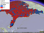
 If you’re a user of Google Earth, sit back and wait while GIS pros suddenly find it much easier to start publishing all manner of interesting data to Google Earth. If you want to see some eyecandy, check out what Arc2Earth can do, or open up this teaser KMZ file of 3D nodes of Yellowstone Park (turn off “Terrain” in Google Earth for best results, as the source for height data is the same).
 If you are a GIS pro and use ESRI’s ArcMap, then Arc2Earth is going to make your life a lot easier if you need to publish to a free, widely available geobrowser — Google Earth. Arc2Earth comes in a $99 standard version and a $299 professional version which adds TIN export, the opening of network links and, in the future, publishing to a server. There is also an API in the works.
To find out exactly what each version can do, check out the feature list, or else dive right into the manual.
Next up, an interview with Brian Flood about Arc2Earth.
If you are a GIS pro and using this to publish data in a way that is easy for your clients to see, then you better make sure that those clients are paying for Google Earth and not breaking the license agreement by using the free version commercially.